1960s Maps of Henefer, Utah
Explore 6 historic maps of Henefer from the 1960s. These maps offer a rare glimpse into what life looked like during the 1960s — showing old roads, neighborhoods, homes, and landmarks that have changed or disappeared over time.
Whether you're researching your family's past, planning a metal detecting trip, or studying how Henefer's landscape evolved across the 1960s, these high-resolution maps are a powerful tool for exploring the history of this region.
- Focus on a specific era: All maps on this page are from the 1960s, giving you a focused view of this time period.
- See what’s changed: Compare century-old streets, trails, and buildings to today's modern landscape using overlays and satellite layers.
- Research with precision: Use these maps for genealogy, historical research, land use analysis, or educational projects.
- View, download, or print: Maps are fully viewable online in high resolution, and can be downloaded or printed for your own records.
Start exploring Henefer's history through authentic maps from the 1960s. This is your window into the past.
Henefer, UT maps
(6)- 1960 Map of Ogden
 1960 Ogden1960 Print · USGSIn the mid-1950s, this region of the American West balanced military expansion with frontier history along the Union Pacific RR. Genealogists and historians can trace old settlements like Fort Bridger, the residential growth of Washington Terrace, and industrial sites from the Hill AFB complex to the coal mines of Kemmerer.
 - 1960 Map of Salt Lake City
 1960 Salt Lake City1960 Print · USGSThe Wasatch Front and High Uintas are captured mid-century as the Salt Lake Valley underwent significant postwar expansion. Genealogists and historians can trace rail lines like the Union Pacific and locate established landmarks such as Fort Douglas, Camp Williams, and the Bingham Canyon Mine.
 - 1961 Map of Devils Slide, 1963 Print
 1961 Devils Slide1963 Print · USGSThe Weber River corridor in the early 1960s shows a landscape of heavy industry and pioneer history. Trace the Donner Party Route as it moves through Henefer Valley past the Cement Plant and Devils Slide Mine.2 unique versions available
 - 1961 Map of Morgan, 1963 Print
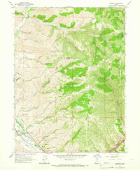
 1961 Morgan1963 Print · USGSThe Weber River valley in the early sixties was a critical junction of rail industry and mountain agriculture. Local historians can trace the industrial footprint of the Cement Plant near Devils Slide and find vanished rural landmarks like the Monastery and Como Springs.2 unique versions available
 - 1964 Map of Henefer, 1966 Print
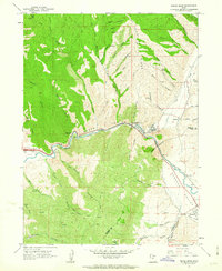
 1964 Henefer1966 Print · USGSThe Henefer Valley in the mid-1960s is shown as a critical mountain transit point along the Weber River. Researchers can trace the Union Pacific rail line, locate the Pioneer Monument, and identify old Claypit workings and the settlement of China Town.2 unique versions available
 - 1967 Map of Coalville, 1970 Print
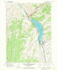 1967 Coalville1970 Print · USGSIn the 1960s, the Weber River valley was a landscape defined by the Union Pacific and the growing Echo Reservoir. Genealogists can trace family landmarks like Tom Harris Hollow or locate the North Summit HS and Cem in Coalville.
End of results
Showing maps 1-6 of 6
Top cities near Henefer
Frequently asked questions
- What are the different types of historical maps available for Henefer?
- What is the oldest map of Henefer?
- Where can I purchase historical maps of Henefer for my home or office?
- Where can I download high-res historical maps of Henefer?
- Are there historical topographic maps available for Henefer?
- Is there historical aerial imagery available for Henefer?
- Where are historical maps of Henefer sourced from?