1970s Maps of Vernon, Utah
Explore 3 historic maps of Vernon from the 1970s. These maps offer a rare glimpse into what life looked like during the 1970s — showing old roads, neighborhoods, homes, and landmarks that have changed or disappeared over time.
Whether you're researching your family's past, planning a metal detecting trip, or studying how Vernon's landscape evolved across the 1970s, these high-resolution maps are a powerful tool for exploring the history of this region.
- Focus on a specific era: All maps on this page are from the 1970s, giving you a focused view of this time period.
- See what’s changed: Compare century-old streets, trails, and buildings to today's modern landscape using overlays and satellite layers.
- Research with precision: Use these maps for genealogy, historical research, land use analysis, or educational projects.
- View, download, or print: Maps are fully viewable online in high resolution, and can be downloaded or printed for your own records.
Start exploring Vernon's history through authentic maps from the 1970s. This is your window into the past.
Vernon, UT maps
(3)- 1971 Map of Faust, 1974 Print
 1971 Faust1974 Print · USGSRush Valley in the early seventies preserves the path of the Old West alongside modern rail infrastructure. Trace the historic route of the Pony Express Road past the Pony Express Station and the Union Pacific line near Faust.
 - 1971 Map of Vernon, 1974 Print
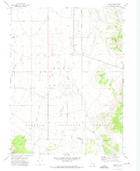 1971 Vernon1974 Print · USGSRanching and federal land management define this portion of Tooele County during the early seventies. Genealogists and historians can locate Vernon Cem, the historical Benmore (Site), and the unique Chief Green Jacket Grave.
 - 1979 Map of Rush Valley
 1979 Rush Valley1979 Print · USGSTooele and Utah Counties during the late seventies reveal a unique transition from historic mining and ranching to modern military operations. Researchers can trace the Union Pacific Railroad past historic sites like Fairfield and mining camps such as Ophir.2 unique versions available
End of results
Showing maps 1-3 of 3
Top cities near Vernon
Frequently asked questions
- What are the different types of historical maps available for Vernon?
- What is the oldest map of Vernon?
- Where can I purchase historical maps of Vernon for my home or office?
- Where can I download high-res historical maps of Vernon?
- Are there historical topographic maps available for Vernon?
- Is there historical aerial imagery available for Vernon?
- Where are historical maps of Vernon sourced from?