1980s Maps of Wasatch County, Utah
Explore 6 historic maps of Wasatch County from the 1980s. These maps offer a rare glimpse into what life looked like during the 1980s — showing old roads, neighborhoods, homes, and landmarks that have changed or disappeared over time.
Whether you're researching your family's past, planning a metal detecting trip, or studying how Wasatch County's landscape evolved across the 1980s, these high-resolution maps are a powerful tool for exploring the history of this region.
- Focus on a specific era: All maps on this page are from the 1980s, giving you a focused view of this time period.
- See what’s changed: Compare century-old streets, trails, and buildings to today's modern landscape using overlays and satellite layers.
- Research with precision: Use these maps for genealogy, historical research, land use analysis, or educational projects.
- View, download, or print: Maps are fully viewable online in high resolution, and can be downloaded or printed for your own records.
Start exploring Wasatch County's history through authentic maps from the 1980s. This is your window into the past.
Wasatch County, UT maps
(6)- 1980 Map of Salt Lake City
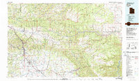
 1980 Salt Lake City1980 Print · USGSSalt Lake City and the surrounding Wasatch Range are shown in the early eighties during a period of rapid suburban growth. Genealogists and historians can trace old mining operations like the Ontario Mine and Wasatch Mine or follow the path of the Union Pacific through the canyons.3 unique versions available
 - 1980 Map of Price, 1987 Print
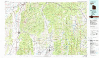
 1980 Price1987 Print · USGSCarbon County in the early 1980s is defined by its deep canyons and intensive coal operations. Researchers can trace the rail spurs and mining works of the Denver and Rio Grande Western Railroad that connect Price, Helper, and the Sunnyside Mine.3 unique versions available
 - 1981 Map of Nephi
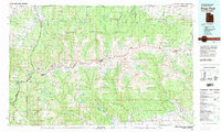
 1981 Nephi1981 Print · USGSThe Juab and Sanpete valleys of central Utah are captured here in the early 1980s, during a period of established mountain settlement and rail-based commerce. Researchers can trace the routes of the Union Pacific and visit traditional communities like Nephi, Mount Pleasant, and Scofield.3 unique versions available
 - 1982 Map of Kings Peak, 1985 Print
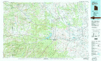
 1982 Kings Peak1985 Print · USGSThe high Uinta wilderness is captured in the early eighties, showing the intersection of three national forests at the Wyoming-Utah border. Hikers and historians can trace the high trails near Kings Peak, Moon Lake, and Iron Mine Mountain.2 unique versions available
 - 1982 Map of Duchesne, 1987 Print
 1982 Duchesne1987 Print · USGSThe high plateaus and river basins of eastern Utah are captured here in the early 1980s, showcasing the region's vital water systems and tribal lands. Researchers can trace the development of the Uintah and Ouray Indian Reservation and locate old crossroads like Tabiona and Upalco.
 - 1986 Map of Provo
 1986 Provo1986 Print · USGSThe Utah Valley during the mid-eighties shows a bustling corridor of growth between the mountains and Utah Lake. Genealogists and historians can trace the rail lines of the Union Pacific RR through settlements like Springville, Spanish Fork, and Payson.
End of results
Showing maps 1-6 of 6
Top cities of Wasatch County
Frequently asked questions
- What are the different types of historical maps available for Wasatch County?
- What is the oldest map of Wasatch County?
- Where can I purchase historical maps of Wasatch County for my home or office?
- Where can I download high-res historical maps of Wasatch County?
- Are there historical topographic maps available for Wasatch County?
- Is there historical aerial imagery available for Wasatch County?
- Where are historical maps of Wasatch County sourced from?