1960s Maps of Heber, Utah
Explore 3 historic maps of Heber from the 1960s. These maps offer a rare glimpse into what life looked like during the 1960s — showing old roads, neighborhoods, homes, and landmarks that have changed or disappeared over time.
Whether you're researching your family's past, planning a metal detecting trip, or studying how Heber's landscape evolved across the 1960s, these high-resolution maps are a powerful tool for exploring the history of this region.
- Focus on a specific era: All maps on this page are from the 1960s, giving you a focused view of this time period.
- See what’s changed: Compare century-old streets, trails, and buildings to today's modern landscape using overlays and satellite layers.
- Research with precision: Use these maps for genealogy, historical research, land use analysis, or educational projects.
- View, download, or print: Maps are fully viewable online in high resolution, and can be downloaded or printed for your own records.
Start exploring Heber's history through authentic maps from the 1960s. This is your window into the past.
Heber, UT maps
(3)- 1960 Map of Salt Lake City
 1960 Salt Lake City1960 Print · USGSThe Wasatch Front and High Uintas are captured mid-century as the Salt Lake Valley underwent significant postwar expansion. Genealogists and historians can trace rail lines like the Union Pacific and locate established landmarks such as Fort Douglas, Camp Williams, and the Bingham Canyon Mine.
 - 1966 Map of Charleston, 1969 Print
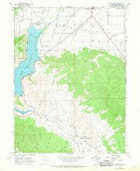 1966 Charleston1969 Print · USGSThe Heber Valley of the mid-1960s is defined by its deep mountain canyons and its sophisticated irrigation systems. Genealogists and researchers can trace local families near Charleston, locate the Cem, or follow the Denver and Rio Grande Western rail lines.
 - 1967 Map of Francis, 1969 Print
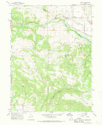 1967 Francis1969 Print · USGSRhodes Valley and the West Hills are captured here during the late 1960s, showing the intersection of Summit and Wasatch counties. Genealogists and local historians can trace the early layout of Francis, locate the local Cemetery, and identify industrial markers like the Mine and Provo Canal.2 unique versions available
End of results
Showing maps 1-3 of 3
Top cities near Heber
- Provo historical maps
- Heber City historical maps
- Park City historical maps
- Snyderville historical maps
- Midway historical maps
- Kamas historical maps
See more
Top neighborhoods of Heber
Frequently asked questions
- What are the different types of historical maps available for Heber?
- What is the oldest map of Heber?
- Where can I purchase historical maps of Heber for my home or office?
- Where can I download high-res historical maps of Heber?
- Are there historical topographic maps available for Heber?
- Is there historical aerial imagery available for Heber?
- Where are historical maps of Heber sourced from?