1970s Maps of Washington County, Utah
Explore 23 historic maps of Washington County from the 1970s. These maps offer a rare glimpse into what life looked like during the 1970s — showing old roads, neighborhoods, homes, and landmarks that have changed or disappeared over time.
Whether you're researching your family's past, planning a metal detecting trip, or studying how Washington County's landscape evolved across the 1970s, these high-resolution maps are a powerful tool for exploring the history of this region.
- Focus on a specific era: All maps on this page are from the 1970s, giving you a focused view of this time period.
- See what’s changed: Compare century-old streets, trails, and buildings to today's modern landscape using overlays and satellite layers.
- Research with precision: Use these maps for genealogy, historical research, land use analysis, or educational projects.
- View, download, or print: Maps are fully viewable online in high resolution, and can be downloaded or printed for your own records.
Start exploring Washington County's history through authentic maps from the 1970s. This is your window into the past.
Washington County, UT maps
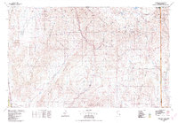
(23)- 1972 Map of Pine Park, 1975 Print
 1972 Pine Park1975 Print · USGSThe Nevada-Utah borderlands near the turn of the 1970s reveal a landscape of remote ranching and high-desert hydrology. Researchers can trace the Union Pacific rail route, locate the Hamblin Ranch, or map springs like Mile High Spring.2 unique versions available
 - 1972 Map of Gunlock, 1976 Print
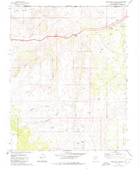
 1972 Gunlock1976 Print · USGSGunlock and the Santa Clara River valley appear in the early seventies as a hub of water management and rural desert life. Genealogists and researchers can trace local landmarks like the Cemetery, the Power Plant, and remote water sources like Manganese Spring.
 - 1972 Map of Pinto, 1976 Print
 1972 Pinto1976 Print · USGSThe settlement of Pinto and the surrounding high country are captured here in the early 1970s. Genealogists and historians can locate the Hamblin Cem, trace the waters of Pinto Creek, and find old Prospects in the heights of the Dixie National Forest.2 unique versions available
 - 1972 Map of Goldstrike, 1976 Print
 1972 Goldstrike1976 Print · USGSThe high desert of Washington County comes alive in the early seventies, showing a rugged landscape defined by mining prospects and pack trails. Researchers can trace the routes to the Emma Mine, explore the heights of Mineral Mountain, and locate remote water sources like Twin Peaks Spring.3 unique versions available
 - 1972 Map of Central West, 1976 Print
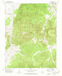
 1972 Central West1976 Print · USGSThe high desert of Washington County is captured here in the early seventies, centered on the Bull Valley Mountains. Researchers can trace the Santa Clara River to Baker Dam Res or locate the Mountain Meadow (Historical Monument) among a network of pack trails.
 - 1972 Map of Motoqua, 1976 Print
 1972 Motoqua1976 Print · USGSMotoqua and the remote canyonlands of southwest Utah are captured here in the early seventies, showing a landscape defined by vital water holes and desert ranches. Researchers can trace the rugged network of Beaver Dam Wash, locate the isolated D I Landing Strip, and find historic water sources like Red Hollow Spring and Hardin Ranch.
 - 1972 Map of Maple Ridge, 1976 Print
 1972 Maple Ridge1976 Print · USGSThe Bull Valley Mountains within the Dixie National Forest are captured here in the early seventies, a land of high ridges and deep canyons. Trace the remote network of a Pack Trail or Jeep Trail leading to landmarks like The Pinnacles and Ox Valley Peak.2 unique versions available
 - 1972 Map of Veyo, 1976 Print
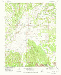 1972 Veyo1976 Print · USGSThe high desert of Washington County is captured here in the early seventies, centered on the volcanic landscape surrounding Veyo. Researchers can trace the path of the Aqueduct, find the prominent Veyo Volcano, and locate the early boundaries of Snow Canyon State Park.2 unique versions available
 - 1972 Map of Saddle Mountain, 1976 Print
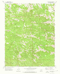
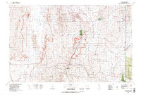
 1972 Saddle Mountain1976 Print · USGSThe Pine Valley Mountains in the early 1970s offer a detailed look at the high-elevation backcountry of Washington County. Researchers can trace historic routes like the Blake-Harmony Tr or locate remote landmarks like Diamond Valley Ranch and Lone Pine Reservoir.
 - 1972 Map of Enterprise, 1976 Print
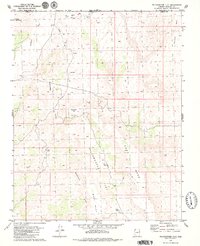
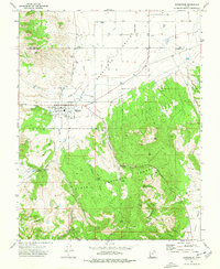 1972 Enterprise1976 Print · USGSEnterprise and the Escalante Valley frontier come to life in this early 1970s topographic record. Researchers can trace family history at the Winsor Mem Cem, locate the local Rodeo Ground, and follow old trails through the Dixie National Forest.
 - 1972 Map of Water Canyon Peak, 1977 Print
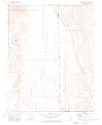
 1972 Water Canyon Peak1977 Print · USGSSouthwestern Utah high country comes alive in the early seventies, spanning the border of Iron and Washington counties. Trace old routes like the Rock Pack Trail and find remote water sources including Dads Spring, Rock Hole Corral, and Upper Enterprise Reservoir.
 - 1972 Map of Central East, 1977 Print
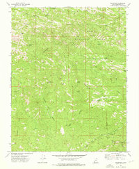
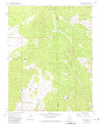
 1972 Central East1977 Print · USGSThe high desert communities of Central and Pine Valley are shown here in the early 1970s as they sit within the Dixie National Forest. Genealogists and historians can trace the many named water sources like Eightmile Spring and remote routes such as the Summit Trail (Pack).2 unique versions available
 - 1972 Map of Hebron, 1977 Print
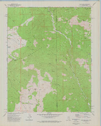
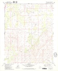
 1972 Hebron1977 Print · USGSThe high desert terrain of Washington County is mapped in the 1970s as it transitions between ranching history and forest management. Researchers can locate Hebron, trace the Hebron Cem, and see the waters of Upper Enterprise Reservoir.
 - 1973 Map of Scarecrow Peak, 1976 Print
 1973 Scarecrow Peak1976 Print · USGSThe high desert borderlands of Utah and Nevada are documented in the early seventies, showing a landscape defined by seasonal drainages and remote peaks. Researchers can trace the path of Beaver Dam Wash and locate Lower Lime Mtn Well and Snow Spring.
 - 1973 Map of Terry Benches, 1976 Print
 1973 Terry Benches1976 Print · USGSThe high desert tri-state corner is captured in the early seventies, showing where Nevada, Utah, and Arizona meet in a landscape of plateaus and washes. Researchers can trace the rugged network of Jeep Trails connecting Initial Mesa, Beaver Dam Wash, and the remote Terry Benches.2 unique versions available
 - 1973 Map of Dodge Spring, 1977 Print
 1973 Dodge Spring1977 Print · USGSThe remote borderlands of Utah and Nevada are captured here in the early 1970s as a landscape of isolated springs and high-country trails. Researchers can trace the paths of jeep trails to Motoqua, Halfway Camp, and various mining Prospects.
 - 1973 Map of Docs Pass, 1983 Print
 1973 Docs Pass1983 Print · USGSThe Nevada-Utah borderlands near the Pine Valley Mountains come to life in this early 1970s survey. You can trace remote water sources and backcountry landmarks like Holts Cabin, Beaver Dam State Park, and the winding Beaver Dam Wash.
 - 1976 Map of Docs Pass
 1976 Docs Pass1976 Print · USGSThe Nevada-Utah borderlands come alive in the mid-seventies, showing a high-elevation backcountry shaped by deep canyons and mountain springs. Genealogists and researchers can trace remote landmarks like Holts Cabin, the mining evidence at a Prospect, and water sources including Ash Spring.
 - 1978 Map of Clover Mts
 1978 Clover Mts1978 Print · USGSEastern Nevada during the late seventies shows a land of remote desert ranges and isolated rail outposts. Trace the Union Pacific line through Rainbow Canyon to find historic stops at Elgin and Carp.2 unique versions available
 - 1978 Map of Caliente, 1995 Print
 1978 Caliente1995 Print · USGSEastern Nevada in the late 1970s was a landscape of deep canyons and active mining operations. Researchers can trace the Union Pacific rail corridor through Caliente or locate early silver and lead sites like the Prince Mine Centennial Shaft.
 - 1979 Map of Yellowhorse Flat
 1979 Yellowhorse Flat1979 Print · USGSThe high plateau of the Arizona-Utah border comes into focus in the late seventies, showing a landscape defined by mesa tops and desert washes. Local historians can trace the movement of early ranchers through remote landmarks like The Well, Blake Pond, and the Pack Trail near Joe Blake Hill.2 unique versions available
 - 1979 Map of Lizard Point
 1979 Lizard Point1979 Print · USGSBig Valley and the Arizona-Utah borderlands are captured here in the late seventies, showing a landscape defined by water scarcity and ranching life. Researchers can trace remote desert outposts and water sources like Gardner Well, Mokaac Spring, and the Corral.2 unique versions available
 - 1979 Map of Purgatory Canyon, 1980 Print
 1979 Purgatory Canyon1980 Print · USGSArizona's borderlands are captured here in the late seventies, showing a landscape defined by ranching and the Virgin River. Researchers can trace old livestock sites like Blakes Lambing Grounds or follow the terrain from Starvation Point to Purgatory Canyon.
End of results
Showing maps 1-23 of 23
Top cities of Washington County
- St. George historical maps
- Washington historical maps
- Hurricane historical maps
- Ivins historical maps
- Santa Clara historical maps
- La Verkin historical maps
See more
Frequently asked questions
- What are the different types of historical maps available for Washington County?
- What is the oldest map of Washington County?
- Where can I purchase historical maps of Washington County for my home or office?
- Where can I download high-res historical maps of Washington County?
- Are there historical topographic maps available for Washington County?
- Is there historical aerial imagery available for Washington County?
- Where are historical maps of Washington County sourced from?