1980s Maps of Fruita, Utah
Explore 2 historic maps of Fruita from the 1980s. These maps offer a rare glimpse into what life looked like during the 1980s — showing old roads, neighborhoods, homes, and landmarks that have changed or disappeared over time.
Whether you're researching your family's past, planning a metal detecting trip, or studying how Fruita's landscape evolved across the 1980s, these high-resolution maps are a powerful tool for exploring the history of this region.
- Focus on a specific era: All maps on this page are from the 1980s, giving you a focused view of this time period.
- See what’s changed: Compare century-old streets, trails, and buildings to today's modern landscape using overlays and satellite layers.
- Research with precision: Use these maps for genealogy, historical research, land use analysis, or educational projects.
- View, download, or print: Maps are fully viewable online in high resolution, and can be downloaded or printed for your own records.
Start exploring Fruita's history through authentic maps from the 1980s. This is your window into the past.
Fruita, UT maps
(2)- 1980 Map of Loa
 1980 Loa1980 Print · USGSCentral Utah's high plateaus and the Fremont River corridor are captured here during the 1980s, showcasing a landscape of high-elevation reservoirs and remote ranching outposts. Genealogists can trace family names and early settlements from Loa and Teasdale to the orchards of Fruita.2 unique versions available
 - 1987 Map of Fruita
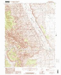 1987 Fruita1987 Print · USGSThe settlement of Fruita is shown at the confluence of desert rivers during the late 1980s, surrounded by the towering cliffs of Capitol Reef. Researchers can trace the geologic uplift of the Waterpocket Fold and locate landmarks like Hickman Natural Bridge and Danish Hill.2 unique versions available
End of results
Showing maps 1-2 of 2
Top cities near Fruita
Frequently asked questions
- What are the different types of historical maps available for Fruita?
- What is the oldest map of Fruita?
- Where can I purchase historical maps of Fruita for my home or office?
- Where can I download high-res historical maps of Fruita?
- Are there historical topographic maps available for Fruita?
- Is there historical aerial imagery available for Fruita?
- Where are historical maps of Fruita sourced from?