1960s Maps of Bennington County, Vermont
Explore 12 historic maps of Bennington County from the 1960s. These maps offer a rare glimpse into what life looked like during the 1960s — showing old roads, neighborhoods, homes, and landmarks that have changed or disappeared over time.
Whether you're researching your family's past, planning a metal detecting trip, or studying how Bennington County's landscape evolved across the 1960s, these high-resolution maps are a powerful tool for exploring the history of this region.
- Focus on a specific era: All maps on this page are from the 1960s, giving you a focused view of this time period.
- See what’s changed: Compare century-old streets, trails, and buildings to today's modern landscape using overlays and satellite layers.
- Research with precision: Use these maps for genealogy, historical research, land use analysis, or educational projects.
- View, download, or print: Maps are fully viewable online in high resolution, and can be downloaded or printed for your own records.
Start exploring Bennington County's history through authentic maps from the 1960s. This is your window into the past.
Bennington County, VT maps
(12)- 1960 Map of Williamstown, 1961 Print
 1960 Williamstown1961 Print · USGSThe Berkshires of western Massachusetts are shown in detail during the early sixties, centered on the college town and the state's highest peak. Researchers can trace the Appalachian Trail over Mt Greylock or locate ancestral sites at Westlawn Cem and Southlawn Cem.2 unique versions available
 - 1960 Map of North Adams, 1961 Print
 1960 North Adams1961 Print · USGSThe Northern Berkshires in the early 1960s reveal a landscape where industrial river towns like NORTH ADAMS and Adams meet high mountain forests. Genealogists and historians can trace local roots through Southview Cem, visit the Natural Bridge, or follow the BOSTON AND MAINE RAILROAD through Zylonite.2 unique versions available
 - 1960 Map of Berlin, 1961 Print
 1960 Berlin1961 Print · USGSRensselaer County at the start of the sixties reveals a valley life shaped by the Taconic Range and the winding Little Hoosic River. Genealogists can trace family heritage through numerous hillside burial grounds like Brimmer Cem and Weaver Cem, or locate landmarks like the Carmelite Novitiate.2 unique versions available
 - 1960 Map of Rowe, 1961 Print
 1960 Rowe1961 Print · USGSThe Berkshires at the start of the 1960s show a landscape shaped by the Deerfield River and the industrial infrastructure of the Boston and Maine RR. Genealogists and historians can trace family plots at Sherman Cem or locate the famed Hoosac Tunnel and the mills at Monroe Bridge.2 unique versions available
 - 1962 Map of Albany
 1962 Albany1962 Print · USGSThe Hudson and Connecticut River valleys meet the Green Mountains and Berkshires in this mid-century overview of the Northeast. Genealogists and historians can trace the industrial hearts of Albany and Springfield or locate features like Quabbin Reservoir and Westover Air Force Base.
 - 1964 Map of Glens Falls
 1964 Glens Falls1964 Print · USGSThe tri-state borderlands of New York, Vermont, and New Hampshire appear here in the mid-1960s. Researchers can trace the rail routes of the Rutland RR and find historic sites like Ticonderoga and Saratoga National Historical Park.
 - 1967 Map of Arlington, 1971 Print
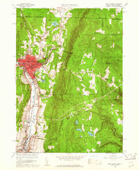
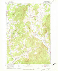
 1967 Arlington1971 Print · USGSArlington and its surrounding hamlets are captured in the late sixties as the valley economy balanced river-side industry and mountain forestry. Researchers can trace the layout of small settlements like Chiselville and Kansas or locate family sites near Evergreen Cem and Fisher Sch.2 unique versions available
 - 1967 Map of West Rupert, 1972 Print
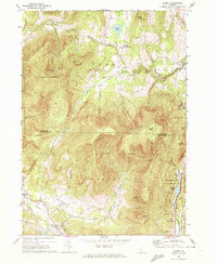
 1967 West Rupert1972 Print · USGSBennington County’s highlands are captured here during the late sixties, showcasing a landscape of steep hollows and mountain forests. Researchers can trace family names across Shatterack Mountain or locate early settlements like West Sandgate and Beartown.
 - 1967 Map of Pawlet, 1972 Print
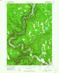
 1967 Pawlet1972 Print · USGSRutland and Bennington counties are shown here in the late sixties, a time when the slate industry and small valley farms still dominated the landscape. Genealogists and historians can trace the Delaware and Hudson rail line or locate family plots in the Mettawee Valley Cem and other local burial grounds.
 - 1967 Map of Dorset, 1972 Print
 1967 Dorset1972 Print · USGSRutland and Bennington Counties are shown here in the late sixties as the mountain marble industry and valley farming shaped the landscape. Researchers can trace the Incline RR near Freedleyville or locate old family plots at Maple Grove Cem.2 unique versions available
 - 1968 Map of Sunderland, 1972 Print
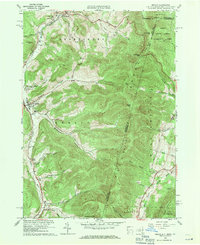
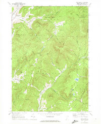
 1968 Sunderland1972 Print · USGSBennington County in the late sixties reveals a landscape where valley farming in Sunderland meets the high wilderness of the Green Mountains. Hikers and historians can trace the Appalachian Trail through remote settlements like East Kansas and Fayville.
 - 1968 Map of Manchester, 1973 Print
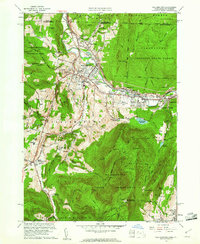
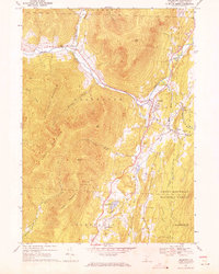
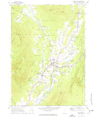 1968 Manchester1973 Print · USGSManchester and the Batten Kill valley appear here in the late sixties, showing a landscape defined by historic village centers and mountain tourism. Genealogists and researchers can locate Burr-Barton Seminary, the Vermont Railway, and several family burial sites like South Village Cem.4 unique versions available
End of results
Showing maps 1-12 of 12
Top cities of Bennington County
- Bennington historical maps
- Shaftsbury historical maps
- Pownal historical maps
- Manchester historical maps
- Dorset historical maps
- Arlington historical maps
See more
Frequently asked questions
- What are the different types of historical maps available for Bennington County?
- What is the oldest map of Bennington County?
- Where can I purchase historical maps of Bennington County for my home or office?
- Where can I download high-res historical maps of Bennington County?
- Are there historical topographic maps available for Bennington County?
- Is there historical aerial imagery available for Bennington County?
- Where are historical maps of Bennington County sourced from?