1970s Maps of Bennington County, Vermont
Explore 8 historic maps of Bennington County from the 1970s. These maps offer a rare glimpse into what life looked like during the 1970s — showing old roads, neighborhoods, homes, and landmarks that have changed or disappeared over time.
Whether you're researching your family's past, planning a metal detecting trip, or studying how Bennington County's landscape evolved across the 1970s, these high-resolution maps are a powerful tool for exploring the history of this region.
- Focus on a specific era: All maps on this page are from the 1970s, giving you a focused view of this time period.
- See what’s changed: Compare century-old streets, trails, and buildings to today's modern landscape using overlays and satellite layers.
- Research with precision: Use these maps for genealogy, historical research, land use analysis, or educational projects.
- View, download, or print: Maps are fully viewable online in high resolution, and can be downloaded or printed for your own records.
Start exploring Bennington County's history through authentic maps from the 1970s. This is your window into the past.
Bennington County, VT maps
(8)- 1973 Map of Williamstown, 1975 Print
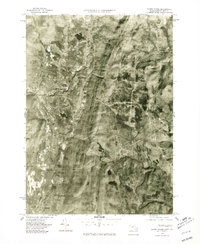
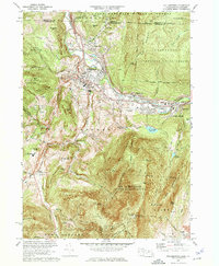 1973 Williamstown1975 Print · USGSThe Berkshires come alive in the early seventies as academic life at Williams College meets the high peaks of the Mt Greylock State Reservation. Researchers can trace old family lands like Mt Hope Farm, find quiet cemeteries like Southlawn Cem, and follow the historic Appalachian Trail.5 unique versions available
 - 1973 Map of North Adams, 1975 Print
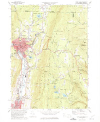 1973 North Adams1975 Print · USGSNorth Adams and its neighboring mountain townships are shown in the early seventies, a landscape where industrial valleys meet state forest peaks. Genealogists and historians can trace rail routes through the Hoosac Tunnel or locate ancestral sites like Hillside Cem and Briggsville.4 unique versions available
 - 1973 Map of Rowe, 1975 Print
 1973 Rowe1975 Print · USGSFranklin County's northwestern highlands appear in the 1970s as a landscape of hydroelectric power and deep-bore rail engineering. You can trace the path of the Mohawk Trail, locate the Hoosac Tunnel entrance, and find small family landmarks like West Cem and Phelps Hill.4 unique versions available
 - 1973 Map of Berlin, 1975 Print
 1973 Berlin1975 Print · USGSRensselaer County’s eastern border comes to life in the early 1970s as small valley towns sit beneath the high peaks of the Taconic Range. Genealogists and local historians can trace family-named sites like Moses Cem, Browns Cem, and the various hollows of Petersburg and Berlin.4 unique versions available
 - 1975 Map of Berlin, 1981 Print
 1975 Berlin1981 Print · USGSThe Rensselaer County highlands are captured in detail in the mid-1970s, showing the agricultural patterns and valley settlements of the Taconic region. Local historians can trace the development of Berlin and Petersburg along the Little Hoosic River.
 - 1975 Map of Rowe, 1981 Print
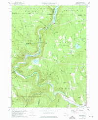
 1975 Rowe1981 Print · USGSThe northern Berkshires and Deerfield River valley appear in high detail during the mid-seventies. Trace the path of the Hoosac Tunnel and explore settlements like Monroe Bridge, Rowe, and Zoar amidst the dense forest and reservoirs.
 - 1975 Map of Williamstown, 1981 Print
 1975 Williamstown1981 Print · USGSThe Berkshires in the mid-1970s are captured in this aerial survey, detailing the industrial and academic corridor of the Hoosic River valley. Researchers can trace land use patterns across Williamstown, North Adams, and the slopes of Mt Greylock.
 - 1975 Map of North Adams, 1981 Print
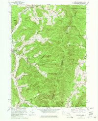
 1975 North Adams1981 Print · USGSNorthern Berkshire County is documented during the mid-seventies, showing the valley floor as it transitions from industrial centers to high peaks. Researchers can trace land use patterns near North Adams, Zylonite, and the steep terrain around Whitcomb Summit.
End of results
Showing maps 1-8 of 8
Top cities of Bennington County
- Bennington historical maps
- Shaftsbury historical maps
- Pownal historical maps
- Manchester historical maps
- Dorset historical maps
- Arlington historical maps
See more
Frequently asked questions
- What are the different types of historical maps available for Bennington County?
- What is the oldest map of Bennington County?
- Where can I purchase historical maps of Bennington County for my home or office?
- Where can I download high-res historical maps of Bennington County?
- Are there historical topographic maps available for Bennington County?
- Is there historical aerial imagery available for Bennington County?
- Where are historical maps of Bennington County sourced from?