1990s Maps of Glastenbury, Vermont
Explore 4 historic maps of Glastenbury from the 1990s. These maps offer a rare glimpse into what life looked like during the 1990s — showing old roads, neighborhoods, homes, and landmarks that have changed or disappeared over time.
Whether you're researching your family's past, planning a metal detecting trip, or studying how Glastenbury's landscape evolved across the 1990s, these high-resolution maps are a powerful tool for exploring the history of this region.
- Focus on a specific era: All maps on this page are from the 1990s, giving you a focused view of this time period.
- See what’s changed: Compare century-old streets, trails, and buildings to today's modern landscape using overlays and satellite layers.
- Research with precision: Use these maps for genealogy, historical research, land use analysis, or educational projects.
- View, download, or print: Maps are fully viewable online in high resolution, and can be downloaded or printed for your own records.
Start exploring Glastenbury's history through authentic maps from the 1990s. This is your window into the past.
Glastenbury, VT maps
(4)- 1997 Map of Bennington, 2000 Print
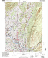 1997 Bennington2000 Print · USGSBennington and its surrounding historic villages are captured here in the late nineties, showing the blend of collegiate life, industrial history, and forest wilderness. Researchers can trace local genealogy and landmarks through the Hinsdillville Cem, the iconic Battle Monument, and the grounds of Bennington College.
 - 1997 Map of Sunderland, 2000 Print
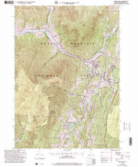
 1997 Sunderland2000 Print · USGSBennington County’s mountain interior is captured here in the late 1990s, revealing the intersection of wilderness recreation and rural outposts. Hikers and historians can trace the Long Trail past Kelley Stand or locate old settlements like Fayville and East Kansas.
 - 1997 Map of Woodford, 2000 Print
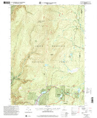 1997 Woodford2000 Print · USGSSouthern Vermont's high country is captured here in the late nineties as recreation and wilderness management reshaped the landscape. Trace the famous Long Trail along the ridge to the Glastenbury Mountain Lookout or locate family roots near Woodford and the Cem.
 - 1997 Map of Arlington, 2000 Print
 1997 Arlington2000 Print · USGSBennington County’s mountain valleys and historic river crossings are captured here in the late nineties, documenting the area's transition into a modern forest and parkland. Genealogists can trace family landmarks and school sites like Fisher Sch or the riverside hamlets of West Arlington and Chiselville.
End of results
Showing maps 1-4 of 4
Top cities near Glastenbury
- Bennington historical maps
- Hoosick historical maps
- Manchester historical maps
- Shaftsbury historical maps
- White Creek historical maps
- Pownal historical maps
See more
Frequently asked questions
- What are the different types of historical maps available for Glastenbury?
- What is the oldest map of Glastenbury?
- Where can I purchase historical maps of Glastenbury for my home or office?
- Where can I download high-res historical maps of Glastenbury?
- Are there historical topographic maps available for Glastenbury?
- Is there historical aerial imagery available for Glastenbury?
- Where are historical maps of Glastenbury sourced from?