1990s Maps of Rupert, Vermont
Explore 6 historic maps of Rupert from the 1990s. These maps offer a rare glimpse into what life looked like during the 1990s — showing old roads, neighborhoods, homes, and landmarks that have changed or disappeared over time.
Whether you're researching your family's past, planning a metal detecting trip, or studying how Rupert's landscape evolved across the 1990s, these high-resolution maps are a powerful tool for exploring the history of this region.
- Focus on a specific era: All maps on this page are from the 1990s, giving you a focused view of this time period.
- See what’s changed: Compare century-old streets, trails, and buildings to today's modern landscape using overlays and satellite layers.
- Research with precision: Use these maps for genealogy, historical research, land use analysis, or educational projects.
- View, download, or print: Maps are fully viewable online in high resolution, and can be downloaded or printed for your own records.
Start exploring Rupert's history through authentic maps from the 1990s. This is your window into the past.
Rupert, VT maps
(6)- 1995 Map of West Rupert, 2000 Print
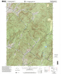 1995 West Rupert2000 Print · USGSBennington County during the mid-1990s reveals a landscape where deep mountain hollows and high peaks dictate the limits of settlement. Genealogists and historians can trace the remote outposts of West Sandgate and Beartown or locate families near Lake Madeleine and Barber Lake.
 - 1995 Map of Pawlet, 2000 Print
 1995 Pawlet2000 Print · USGSThe Mettawee River valley in the mid-1990s reveals a Vermont landscape defined by small river-towns and timbered highlands. Genealogists and local historians can trace family locations near Mettawee Valley Cem or investigate industrial sites like the various Quarries and the Mach Airfield.
 - 1995 Map of Salem, 2000 Print
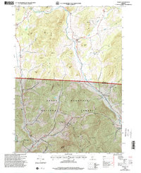
 1995 Salem2000 Print · USGSThe rural landscape of the New York-Vermont border is captured here during the mid-1990s, centering on the valley of the Batten Kill. Researchers can trace old family names and settlements through landmarks like Evergreen Cem, Rexleigh, and the rail junction at Greenwich Junc.
 - 1995 Map of West Pawlet, 2000 Print
 1995 West Pawlet2000 Print · USGSCrossing the New York and Vermont border in the mid-1990s, this area shows a landscape of upland ridges and clustered valley hamlets. Researchers can trace rural lineages through numerous sites like Taylor Hill Cem or locate the site of Chamberlain Mills along the creek beds.2 unique versions available
 - 1997 Map of Manchester, 2000 Print
 1997 Manchester2000 Print · USGSThe Batten Kill valley of Bennington County is captured in the late 1990s, showing a landscape defined by historic rail corridors and mountain peaks. Researchers can trace family roots through the Dellwood Cem or explore institutional sites like Burr-Barton Seminary and the Manchester Ranger Station.
 - 1997 Map of Dorset, 2000 Print
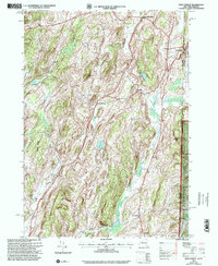
 1997 Dorset2000 Print · USGSThe Green Mountains of Vermont during the late nineties reveal a landscape of high-elevation peaks and narrow valley settlements. Genealogists and historians can trace family sites at Maple Grove Cem or locate industrial stone works at the Quarries near Freedleyville.
End of results
Showing maps 1-6 of 6
Top cities near Rupert
- Granville historical maps
- Fort Ann historical maps
- Greenwich historical maps
- Manchester historical maps
- Whitehall historical maps
- Argyle historical maps
See more
Top neighborhoods of Rupert
Frequently asked questions
- What are the different types of historical maps available for Rupert?
- What is the oldest map of Rupert?
- Where can I purchase historical maps of Rupert for my home or office?
- Where can I download high-res historical maps of Rupert?
- Are there historical topographic maps available for Rupert?
- Is there historical aerial imagery available for Rupert?
- Where are historical maps of Rupert sourced from?