1970s Maps of Franklin County, Vermont
Explore 6 historic maps of Franklin County from the 1970s. These maps offer a rare glimpse into what life looked like during the 1970s — showing old roads, neighborhoods, homes, and landmarks that have changed or disappeared over time.
Whether you're researching your family's past, planning a metal detecting trip, or studying how Franklin County's landscape evolved across the 1970s, these high-resolution maps are a powerful tool for exploring the history of this region.
- Focus on a specific era: All maps on this page are from the 1970s, giving you a focused view of this time period.
- See what’s changed: Compare century-old streets, trails, and buildings to today's modern landscape using overlays and satellite layers.
- Research with precision: Use these maps for genealogy, historical research, land use analysis, or educational projects.
- View, download, or print: Maps are fully viewable online in high resolution, and can be downloaded or printed for your own records.
Start exploring Franklin County's history through authentic maps from the 1970s. This is your window into the past.
Franklin County, VT maps
(6)- 1977 Map of Richford Port of Entry, 1978 Print
 1977 Richford Port of Entry1978 Print · USGSThe Vermont-Quebec borderlands come into sharp focus in the late seventies, showing the industrial and agricultural rhythm of this international crossing. Researchers can trace the dual rail lines of the Canadian Pacific and Central Vermont or locate border facilities like Abercorn Canadian Customs.
 - 1977 Map of West Berkshire Station, 1978 Print
 1977 West Berkshire Station1978 Print · USGSThe international border at Franklin, Vermont, and southern Quebec is seen here in the late seventies. Researchers can trace land use patterns and local landmarks like Lake Carmi, West Berkshire, and the Pike River.
 - 1977 Map of Highgate Springs Port Of Entry, 1978 Print
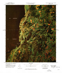 1977 Highgate Springs Port Of Entry1978 Print · USGSThe Vermont-Quebec borderlands come into sharp focus in this late seventies aerial survey of the Highgate Springs area. Researchers can trace the exact footprint of the Highgate Springs crossing, the rural layout of Saint Armand-Station, and the shores of Baie Missisquoi.
 - 1977 Map of East Richford Station, 1978 Print
 1977 East Richford Station1978 Print · USGSThe Vermont-Quebec borderlands are captured in the late seventies, showing the industrial and regulatory landscape of this international river valley. Researchers can trace the Canadian Pacific line through Stevens Mills or locate the East Richford Station U S Customs.
 - 1977 Map of Alburg Springs Station, 1978 Print
 1977 Alburg Springs Station1978 Print · USGSThe northern Vermont borderlands at the end of the 1970s reveal a landscape shaped by international transit and the waters of Lake Champlain. Genealogists and historians can trace the rail lines of the Canadian National Railroad and locate settlements like Alburg Springs and Aird.
 - 1977 Map of Morses Line Station, 1978 Print
 1977 Morses Line Station1978 Print · USGSThe Vermont-Quebec borderlands come into focus during the late seventies, showing the rural farming landscape around Morses Line. Genealogists and local historians can trace family-named crossroads like Campbell Corners and Browns Corners near the northern shore of Lake Carmi.
End of results
Showing maps 1-6 of 6
Top cities of Franklin County
- Saint Albans City historical maps
- Swanton historical maps
- Fairfax historical maps
- Richford historical maps
- Sheldon historical maps
- Fairfield historical maps
See more
Frequently asked questions
- What are the different types of historical maps available for Franklin County?
- What is the oldest map of Franklin County?
- Where can I purchase historical maps of Franklin County for my home or office?
- Where can I download high-res historical maps of Franklin County?
- Are there historical topographic maps available for Franklin County?
- Is there historical aerial imagery available for Franklin County?
- Where are historical maps of Franklin County sourced from?