1950s Maps of Franklin County, Vermont
Explore 5 historic maps of Franklin County from the 1950s. These maps offer a rare glimpse into what life looked like during the 1950s — showing old roads, neighborhoods, homes, and landmarks that have changed or disappeared over time.
Whether you're researching your family's past, planning a metal detecting trip, or studying how Franklin County's landscape evolved across the 1950s, these high-resolution maps are a powerful tool for exploring the history of this region.
- Focus on a specific era: All maps on this page are from the 1950s, giving you a focused view of this time period.
- See what’s changed: Compare century-old streets, trails, and buildings to today's modern landscape using overlays and satellite layers.
- Research with precision: Use these maps for genealogy, historical research, land use analysis, or educational projects.
- View, download, or print: Maps are fully viewable online in high resolution, and can be downloaded or printed for your own records.
Start exploring Franklin County's history through authentic maps from the 1950s. This is your window into the past.
Franklin County, VT maps
(5)- 1950 Map of Lake Champlain
 1950 Lake Champlain1950 Print · USGSThe Lake Champlain valley and its surrounding peaks are captured in detail during the late 1940s, showing the vital rail and road connections between New York and Vermont. Researchers can trace the routes of the Central Vermont Railway or locate old industrial centers like Mineville and Witherbee.2 unique versions available
 - 1953 Map of Jay Peak, 1954 Print
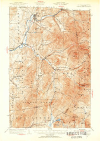 1953 Jay Peak1954 Print · USGSNorthern Vermont's Green Mountains meet the Canadian border in this mid-century survey of the high peaks and river valleys. Researchers can trace the legacy of timber and mining at Tillotson Mill and the ASBESTOS MINE, or locate rural schools like Woodward School.4 unique versions available
 - 1953 Map of Enosburg Falls, 1955 Print
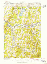 1953 Enosburg Falls1955 Print · USGSNorthern Vermont in the early fifties shows a landscape of river-powered industry and rail-connected villages. Genealogists can trace family lines through named sites like Pumpkin Village School, Gilberts Tannery, and numerous rural cemeteries including Patten Cem.4 unique versions available
 - 1956 Map of Rouses Point, 1958 Print
 1956 Rouses Point1958 Print · USGSLake Champlain's northern islands and shoreline are captured here in the mid-1950s, where the New York and Vermont borders meet Quebec. Researchers can locate family landmarks like the Miner Institute, St Marys Cem, and the ruins of Fort Montgomery.2 unique versions available
 - 1958 Map of Lake Champlain
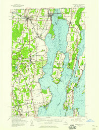
 1958 Lake Champlain1958 Print · USGSThe Champlain Valley and surrounding high peaks are captured here in the late fifties, showcasing the cross-border region from the Adirondacks to the Green Mountains. Researchers can trace historic rail routes like the Rutland Railway or locate old valley settlements such as Keeseville and Vergennes.2 unique versions available
End of results
Showing maps 1-5 of 5
Top cities of Franklin County
- Saint Albans City historical maps
- Swanton historical maps
- Fairfax historical maps
- Richford historical maps
- Sheldon historical maps
- Fairfield historical maps
See more
Frequently asked questions
- What are the different types of historical maps available for Franklin County?
- What is the oldest map of Franklin County?
- Where can I purchase historical maps of Franklin County for my home or office?
- Where can I download high-res historical maps of Franklin County?
- Are there historical topographic maps available for Franklin County?
- Is there historical aerial imagery available for Franklin County?
- Where are historical maps of Franklin County sourced from?