1980s Maps of Franklin County, Vermont
Explore 10 historic maps of Franklin County from the 1980s. These maps offer a rare glimpse into what life looked like during the 1980s — showing old roads, neighborhoods, homes, and landmarks that have changed or disappeared over time.
Whether you're researching your family's past, planning a metal detecting trip, or studying how Franklin County's landscape evolved across the 1980s, these high-resolution maps are a powerful tool for exploring the history of this region.
- Focus on a specific era: All maps on this page are from the 1980s, giving you a focused view of this time period.
- See what’s changed: Compare century-old streets, trails, and buildings to today's modern landscape using overlays and satellite layers.
- Research with precision: Use these maps for genealogy, historical research, land use analysis, or educational projects.
- View, download, or print: Maps are fully viewable online in high resolution, and can be downloaded or printed for your own records.
Start exploring Franklin County's history through authentic maps from the 1980s. This is your window into the past.
Franklin County, VT maps
(10)- 1986 Map of Fairfield
 1986 Fairfield1986 Print · USGSFranklin County's rural character is preserved here during the mid-1980s, showcasing the intersection of small-town life and large-scale wildlife conservation. Researchers can trace the layout of Fairfield, locate local landmarks like St Rocks, and explore the wetlands of the Fairfield Swamp State Wildlife Management Area.2 unique versions available
 - 1986 Map of Lake Champlain North
 1986 Lake Champlain North1986 Print · USGSThe Lake Champlain borderlands in the mid-1980s show a mix of mountain villages and busy island shorelines. Researchers can trace the Delaware and Hudson RR through Plattsburgh or locate old rural sites like Mooers Forks and St Josephs Cem.2 unique versions available
 - 1986 Map of Jay Peak, 1987 Print
 1986 Jay Peak1987 Print · USGSThe high peaks of the northern Green Mountains meet the Canadian border in the late twentieth century. Researchers can trace the river-valley settlements of Montgomery Center and Stevens Mills or locate high-altitude landmarks like Jay Peak and Domeys Dome.2 unique versions available
 - 1986 Map of Sheldon Springs, 1987 Print
 1986 Sheldon Springs1987 Print · USGSAcross the northern Vermont borderlands in the mid-eighties, this survey reveals a landscape of river-valley hamlets and glacial hills. Genealogists and local historians can trace the foundations of Sheldon Springs, Morses Line, and the recreation areas around Lake Carmi.
 - 1986 Map of Hazens Notch, 1987 Print
 1986 Hazens Notch1987 Print · USGSThe Green Mountains of northern Vermont are captured here in the mid-1980s, centered on the high pass of Hazens Notch. Trace local industrial history at the Strip Mine or locate historic landmarks like the Covered Bridge in Hectorville and the Tillotson Mill.
 - 1986 Map of Cold Hollow Mountains, 1987 Print
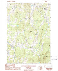
 1986 Cold Hollow Mountains1987 Print · USGSThe northern Green Mountains in the mid-1980s are captured here during a period of transition in Vermont's highland forests. Researchers can trace the remote drainage of Cold Hollow Brook, locate Belvidere Center, and identify family landmarks like West Hill.
 - 1986 Map of Enosburg Falls, 1987 Print
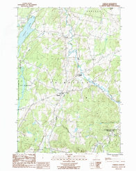
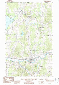 1986 Enosburg Falls1987 Print · USGSFranklin County in the mid-eighties remains a landscape of river-valley settlements and quiet border towns. Researchers can trace the layout of Enosburg Falls, locate family plots in local Cem sites, or explore the area around Lake Carmi.
 - 1986 Map of Bakersfield, 1987 Print
 1986 Bakersfield1987 Print · USGSBakersfield and the rural valleys of Franklin County are captured here in the mid-1980s, documenting a landscape of upland ridges and old crossroads. Researchers can trace historic industrial sites like Gilberts Tannery and local hamlets including Bordoville and West Enosburg.
 - 1986 Map of Richford, 1987 Print
 1986 Richford1987 Print · USGSFranklin County, Vermont, sits along the Canadian border in the early 1980s as a landscape of river valleys and upland hills. Genealogists and historians can trace the roads connecting Richford, East Berkshire, and Montgomery, or locate the historic Covered Bridge.
 - 1989 Map of Mount Mansfield
 1989 Mount Mansfield1989 Print · USGSNorthern Vermont in the late eighties remains a landscape of deep forests and isolated mountain villages. Genealogists and hikers can trace the old rail lines of the Canadian Pacific RR or locate family sites near Lake Willoughby and Brownington Village.
End of results
Showing maps 1-10 of 10
Top cities of Franklin County
- Saint Albans City historical maps
- Swanton historical maps
- Fairfax historical maps
- Richford historical maps
- Sheldon historical maps
- Fairfield historical maps
See more
Frequently asked questions
- What are the different types of historical maps available for Franklin County?
- What is the oldest map of Franklin County?
- Where can I purchase historical maps of Franklin County for my home or office?
- Where can I download high-res historical maps of Franklin County?
- Are there historical topographic maps available for Franklin County?
- Is there historical aerial imagery available for Franklin County?
- Where are historical maps of Franklin County sourced from?