1960s Maps of Franklin County, Vermont
Explore 6 historic maps of Franklin County from the 1960s. These maps offer a rare glimpse into what life looked like during the 1960s — showing old roads, neighborhoods, homes, and landmarks that have changed or disappeared over time.
Whether you're researching your family's past, planning a metal detecting trip, or studying how Franklin County's landscape evolved across the 1960s, these high-resolution maps are a powerful tool for exploring the history of this region.
- Focus on a specific era: All maps on this page are from the 1960s, giving you a focused view of this time period.
- See what’s changed: Compare century-old streets, trails, and buildings to today's modern landscape using overlays and satellite layers.
- Research with precision: Use these maps for genealogy, historical research, land use analysis, or educational projects.
- View, download, or print: Maps are fully viewable online in high resolution, and can be downloaded or printed for your own records.
Start exploring Franklin County's history through authentic maps from the 1960s. This is your window into the past.
Franklin County, VT maps
(6)- 1962 Map of Lake Champlain, 1975 Print
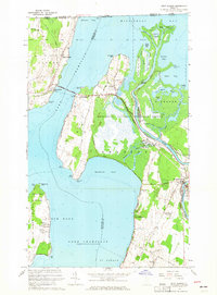
 1962 Lake Champlain1975 Print · USGSLake Champlain and the high peaks of the Adirondacks and Green Mountains are captured here during the mid-twentieth century. Researchers can trace the industrial legacy of the Lyon Mountain Mine and the rail corridors of the Central Vermont RR and Delaware & Hudson RR.3 unique versions available
 - 1964 Map of East Alburg, 1965 Print
 1964 East Alburg1965 Print · USGSLake Champlain's northern reaches and the Vermont-Quebec border come into focus in the mid-1960s. Trace the lakeside history of Alburg Springs or locate rural family landmarks like Tabor Cem and the Riverside Cem near the Missisquoi River.3 unique versions available
 - 1964 Map of Highgate Center, 1965 Print
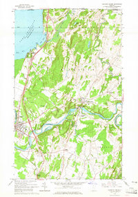 1964 Highgate Center1965 Print · USGSFranklin County in the mid-sixties reveals a landscape of international borders and river-powered industry along the Missisquoi River. Genealogists can trace deep local roots through numerous burial sites like Stimet Cem and Webster Cem or explore the rail hubs at Swanton Junction.3 unique versions available
 - 1964 Map of St. Albans Bay, 1965 Print
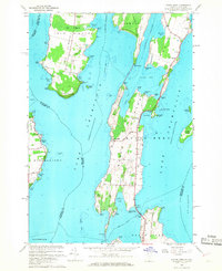
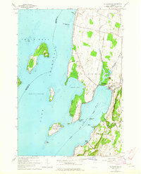 1964 St. Albans Bay1965 Print · USGSLake Champlain's eastern shoreline in the 1960s reveals a blend of island life and coastal Vermont settlements. Researchers can trace historic family burial sites at Waller Cem, explore the early footprint of Burton Island State Park, or locate the State Boat Dock at St Albans Bay.2 unique versions available
 - 1964 Map of St. Albans, 1965 Print
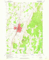 1964 St. Albans1965 Print · USGSMid-century Franklin County comes to life in this detailed record of the rail and civic infrastructure in St Albans. Genealogists and researchers can trace local families through several burial sites like Warner Cem and Kingsbury Cem, or locate rural landmarks like Greens Corners and the Swamp Sch.3 unique versions available
 - 1966 Map of North Hero, 1968 Print
 1966 North Hero1968 Print · USGSLake Champlain's islands in the mid-1960s reveal a landscape of seasonal camps, quarries, and historic crossings. Genealogists and local historians can trace family-named sites like Fisk Point and Hyde Cem or follow the path of the Old Railroad Grade.3 unique versions available
End of results
Showing maps 1-6 of 6
Top cities of Franklin County
- Saint Albans City historical maps
- Swanton historical maps
- Fairfax historical maps
- Richford historical maps
- Sheldon historical maps
- Fairfield historical maps
See more
Frequently asked questions
- What are the different types of historical maps available for Franklin County?
- What is the oldest map of Franklin County?
- Where can I purchase historical maps of Franklin County for my home or office?
- Where can I download high-res historical maps of Franklin County?
- Are there historical topographic maps available for Franklin County?
- Is there historical aerial imagery available for Franklin County?
- Where are historical maps of Franklin County sourced from?