1930s Maps of Lamoille County, Vermont
Explore 4 historic maps of Lamoille County from the 1930s. These maps offer a rare glimpse into what life looked like during the 1930s — showing old roads, neighborhoods, homes, and landmarks that have changed or disappeared over time.
Whether you're researching your family's past, planning a metal detecting trip, or studying how Lamoille County's landscape evolved across the 1930s, these high-resolution maps are a powerful tool for exploring the history of this region.
- Focus on a specific era: All maps on this page are from the 1930s, giving you a focused view of this time period.
- See what’s changed: Compare century-old streets, trails, and buildings to today's modern landscape using overlays and satellite layers.
- Research with precision: Use these maps for genealogy, historical research, land use analysis, or educational projects.
- View, download, or print: Maps are fully viewable online in high resolution, and can be downloaded or printed for your own records.
Start exploring Lamoille County's history through authentic maps from the 1930s. This is your window into the past.
Lamoille County, VT maps
(4)- 1930 Map of Hyde Park
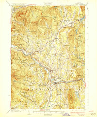 1930 Hyde Park1930 Print · USGSLamoille County in the late twenties shows a landscape of busy river towns and upland mines connected by the St Johnsbury and Lake Champlain Railroad. Trace early school districts like McKinistry Sch. or locate old operations at the Talc Mine and Upper Diggings.4 unique versions available
 - 1934 Map of Hardwick
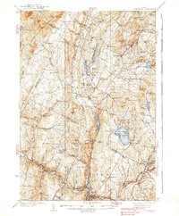
 1934 Hardwick1934 Print · USGSUpper Vermont's hill towns and river valleys are captured here in the mid-1930s, showing a landscape tied to the Lamoille River and small-town industry. Researchers can trace dozens of rural schoolhouses like Collinsville Sch and landmarks such as Jackson Bridge.
 - 1938 Map of Hardwick
 1938 Hardwick1938 Print · USGSVermont’s northern hills and the Lamoille River valley are shown in the late 1930s, documenting a time when rural schools and the railroad connected the highlands. Trace family roots through sites like Hazen Road Sch, Greensboro Bend, and the ST JOHNSBURY AND LAKE CHAMPLAIN RR.2 unique versions available
 - 1939 Map of Plainfield
 1939 Plainfield1939 Print · USGSVermont's granite-and-timber country is captured here on the eve of the 1940s, when remote rail lines still connected upland villages. Genealogists can trace family names at the Old West Ch, Hollister Hill Sch, and the isolated Lanesboro rail stop.
End of results
Showing maps 1-4 of 4
Top cities of Lamoille County
- Stowe historical maps
- Johnson historical maps
- Hyde Park historical maps
- Morristown historical maps
- Wolcott historical maps
- Eden historical maps
See more
Frequently asked questions
- What are the different types of historical maps available for Lamoille County?
- What is the oldest map of Lamoille County?
- Where can I purchase historical maps of Lamoille County for my home or office?
- Where can I download high-res historical maps of Lamoille County?
- Are there historical topographic maps available for Lamoille County?
- Is there historical aerial imagery available for Lamoille County?
- Where are historical maps of Lamoille County sourced from?