1990s Maps of Lamoille County, Vermont
Explore 4 historic maps of Lamoille County from the 1990s. These maps offer a rare glimpse into what life looked like during the 1990s — showing old roads, neighborhoods, homes, and landmarks that have changed or disappeared over time.
Whether you're researching your family's past, planning a metal detecting trip, or studying how Lamoille County's landscape evolved across the 1990s, these high-resolution maps are a powerful tool for exploring the history of this region.
- Focus on a specific era: All maps on this page are from the 1990s, giving you a focused view of this time period.
- See what’s changed: Compare century-old streets, trails, and buildings to today's modern landscape using overlays and satellite layers.
- Research with precision: Use these maps for genealogy, historical research, land use analysis, or educational projects.
- View, download, or print: Maps are fully viewable online in high resolution, and can be downloaded or printed for your own records.
Start exploring Lamoille County's history through authentic maps from the 1990s. This is your window into the past.
Lamoille County, VT maps
(4)- 1997 Map of Mount Mansfield, 2000 Print
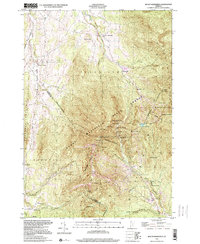 1997 Mount Mansfield2000 Print · USGSThe Green Mountains near the Lamoille and Chittenden county line are captured here in the late 1990s, showcasing a landscape of high summits and recreational heritage. Researchers can trace the Long Trail past Taft Lodge or locate the old Harvey Sch and Morses Mill in the valleys.
 - 1998 Map of Sterling Mountain, 2001 Print
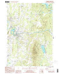
 1998 Sterling Mountain2001 Print · USGSThe Sterling Range and Mt. Mansfield State Forest define the Vermont landscape at the end of the millennium. Genealogists and hikers can trace old routes near West Settlement, Mud City, and the slopes of Sterling Mtn.
 - 1999 Map of Morrisville, 2000 Print
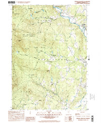
 1999 Morrisville2000 Print · USGSLamoille County's river valleys and mountain ridges are captured in detail during the late nineties. Researchers can trace the heritage of Morrisville and Hyde Park or locate family sites near Cleveland Corners, Cadys Falls, and the Lower Diggings.
 - 1999 Map of Mount Worcester, 2000 Print
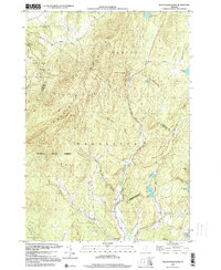 1999 Mount Worcester2000 Print · USGSVermont's Green Mountain spine near the end of the century is defined by the high peaks of the Worcester Mountains and the winding North Branch. Researchers can trace the protected boundaries of Putnam State Forest and find remote landmarks like Moss Glen Falls and Hardwood Pond.
End of results
Showing maps 1-4 of 4
Top cities of Lamoille County
- Stowe historical maps
- Johnson historical maps
- Hyde Park historical maps
- Morristown historical maps
- Wolcott historical maps
- Eden historical maps
See more
Frequently asked questions
- What are the different types of historical maps available for Lamoille County?
- What is the oldest map of Lamoille County?
- Where can I purchase historical maps of Lamoille County for my home or office?
- Where can I download high-res historical maps of Lamoille County?
- Are there historical topographic maps available for Lamoille County?
- Is there historical aerial imagery available for Lamoille County?
- Where are historical maps of Lamoille County sourced from?