1980s Maps of Rutland County, Vermont
Explore 10 historic maps of Rutland County from the 1980s. These maps offer a rare glimpse into what life looked like during the 1980s — showing old roads, neighborhoods, homes, and landmarks that have changed or disappeared over time.
Whether you're researching your family's past, planning a metal detecting trip, or studying how Rutland County's landscape evolved across the 1980s, these high-resolution maps are a powerful tool for exploring the history of this region.
- Focus on a specific era: All maps on this page are from the 1980s, giving you a focused view of this time period.
- See what’s changed: Compare century-old streets, trails, and buildings to today's modern landscape using overlays and satellite layers.
- Research with precision: Use these maps for genealogy, historical research, land use analysis, or educational projects.
- View, download, or print: Maps are fully viewable online in high resolution, and can be downloaded or printed for your own records.
Start exploring Rutland County's history through authentic maps from the 1980s. This is your window into the past.
Rutland County, VT maps
(10)- 1985 Map of Claremont, 1986 Print
 1985 Claremont1986 Print · USGSUpper Valley and Green Mountain life are captured here in the mid-eighties, centered on the river-linked hubs of Claremont and Springfield. Trace old family routes and rail lines like the Boston & Maine RR, or locate properties near Lake Sunapee and Mount Ascutney State Park.2 unique versions available
 - 1985 Map of Rutland, 1988 Print
 1985 Rutland1988 Print · USGSThe Upper Valley of the mid-1980s comes to life along the winding Connecticut River as it divides the Green Mountain and Granite states. Historians can trace the industrial rail hubs of White River Junction and the paths of the Appalachian Trail and Long Trail.
 - 1986 Map of Glens Falls
 1986 Glens Falls1986 Print · USGSThe Upper Hudson Valley and Vermont borderlands come together in this mid-eighties survey of industrial river towns and mountain retreats. Genealogists and historians can trace the rail lines of the Delaware and Hudson Railway or locate landmarks like the Mount McGregor Correctional Facility and Saratoga Spa State Park.2 unique versions available
 - 1986 Map of Ticonderoga
 1986 Ticonderoga1986 Print · USGSThe Lake Champlain valley in the mid-eighties shows a landscape defined by Revolutionary War history and deep wilderness. Researchers can trace the Delaware and Hudson RR through the mountains or locate local landmarks like Fort Ticonderoga, St. Genevieve Cem, and the Ore Bed.
 - 1986 Map of Mount Holly, 1987 Print
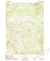 1986 Mount Holly1987 Print · USGSMount Holly and the surrounding Vermont highlands are shown here in the 1980s as a landscape of timber forests and tight-knit mountain villages. Researchers can trace historic settlements like Belmont, Tarbellville, and East Wallingford along the banks of the Mill River.2 unique versions available
 - 1986 Map of Danby, 1987 Print
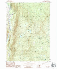 1986 Danby1987 Print · USGSThe Green Mountains of the mid-eighties rise above the Otter Creek valley, where Danby and Mount Tabor meet the forest edge. Trace the path of the Appalachian Trail over summits like Baker Peak and find the historic South End Cem.2 unique versions available
 - 1986 Map of Weston, 1987 Print
 1986 Weston1987 Print · USGSIn the mid-1980s, the mountain valleys of Windsor County maintained a quiet network of small settlements and protected forests. Trace the secluded grounds of Weston Priory, family plots at Cem sites, and the heights of Morgan Hill.2 unique versions available
 - 1986 Map of Wallingford, 1987 Print
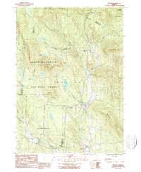
 1986 Wallingford1987 Print · USGSVermont's Green Mountains were well-established as a recreational and industrial hub in the mid-1980s. Local researchers can trace the winding Appalachian Trail through the Green Mountain National Forest or locate valley landmarks like the Marble Quarry and Elfin Lake.
 - 1989 Map of Ticonderoga
 1989 Ticonderoga1989 Print · USGSThe Champlain Valley and Adirondack foothills meet in the late eighties, documenting a historic borderland defined by mountain lakes and timber. Genealogists and historians can trace the paths of the Delaware and Hudson RR or locate the Hubbardton Battlefield State Historic Site.2 unique versions available
 - 1989 Map of Glens Falls
 1989 Glens Falls1989 Print · USGSThe Upper Hudson Valley and the Vermont borderlands are captured here during the late eighties, showing a landscape of river-town industry and mountain recreation. Researchers can trace the Champlain Canal, the Delaware and Hudson RR, and historic sites like Saratoga National Historical Park.
End of results
Showing maps 1-10 of 10
Top cities of Rutland County
- Rutland City historical maps
- Brandon historical maps
- Poultney historical maps
- Fair Haven historical maps
- Clarendon historical maps
- Wallingford historical maps
See more
Frequently asked questions
- What are the different types of historical maps available for Rutland County?
- What is the oldest map of Rutland County?
- Where can I purchase historical maps of Rutland County for my home or office?
- Where can I download high-res historical maps of Rutland County?
- Are there historical topographic maps available for Rutland County?
- Is there historical aerial imagery available for Rutland County?
- Where are historical maps of Rutland County sourced from?