1920s Maps of Rutland County, Vermont
Explore 4 historic maps of Rutland County from the 1920s. These maps offer a rare glimpse into what life looked like during the 1920s — showing old roads, neighborhoods, homes, and landmarks that have changed or disappeared over time.
Whether you're researching your family's past, planning a metal detecting trip, or studying how Rutland County's landscape evolved across the 1920s, these high-resolution maps are a powerful tool for exploring the history of this region.
- Focus on a specific era: All maps on this page are from the 1920s, giving you a focused view of this time period.
- See what’s changed: Compare century-old streets, trails, and buildings to today's modern landscape using overlays and satellite layers.
- Research with precision: Use these maps for genealogy, historical research, land use analysis, or educational projects.
- View, download, or print: Maps are fully viewable online in high resolution, and can be downloaded or printed for your own records.
Start exploring Rutland County's history through authentic maps from the 1920s. This is your window into the past.
Rutland County, VT maps
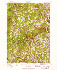
(4)- 1920 Map of Brandon
 1920 Brandon1920 Print · USGSVermont's western foothills and the Otter Creek valley are shown in detail during the early twentieth century. Researchers can trace the Rutland R. R. through Leicester Junction and find historic landmarks like Hyde Manor and the Lime Kiln.
 - 1927 Map of Orwell
 1927 Orwell1927 Print · USGSMid-century Addison County reveals a landscape shaped by the Rutland Railroad and the Lake Champlain shoreline. Genealogists and local historians can trace family-named sites from Larrabees Point to Orwell and locate rural landmarks like Hough Crossing School.
 - 1928 Map of Ludlow
 1928 Ludlow1928 Print · USGSWindsor County's industrial river valleys and upland hill farms are captured here in the late twenties just as early aviation arrived. Trace family roots through numerous district schools like Baltimore Sch and vanished post offices at Peaseville.
 - 1929 Map of Ludlow, 1961 Print
 1929 Ludlow1961 Print · USGSThe Black River valley and its busy rail corridor define this Vermont landscape in the late 1920s. Researchers can trace the legacy of rural education at Sawyer Stand Sch and locate vanished local landmarks like Baileys Mills or Grout Cem.2 unique versions available
End of results
Showing maps 1-4 of 4
Top cities of Rutland County
- Rutland City historical maps
- Brandon historical maps
- Poultney historical maps
- Fair Haven historical maps
- Clarendon historical maps
- Wallingford historical maps
See more
Frequently asked questions
- What are the different types of historical maps available for Rutland County?
- What is the oldest map of Rutland County?
- Where can I purchase historical maps of Rutland County for my home or office?
- Where can I download high-res historical maps of Rutland County?
- Are there historical topographic maps available for Rutland County?
- Is there historical aerial imagery available for Rutland County?
- Where are historical maps of Rutland County sourced from?