1900s (20th Century) Maps of Windsor County, Vermont
Explore 92 historic maps of Windsor County from the 1900s (20th Century). These maps offer a rare glimpse into what life looked like during the 1900s — showing old roads, neighborhoods, homes, and landmarks that have changed or disappeared over time.
Whether you're researching your family's past, planning a metal detecting trip, or studying how Windsor County's landscape evolved across the 1900s, these high-resolution maps are a powerful tool for exploring the history of this region.
- Focus on a specific era: All maps on this page are from the 1900s, giving you a focused view of this time period.
- See what’s changed: Compare century-old streets, trails, and buildings to today's modern landscape using overlays and satellite layers.
- Research with precision: Use these maps for genealogy, historical research, land use analysis, or educational projects.
- View, download, or print: Maps are fully viewable online in high resolution, and can be downloaded or printed for your own records.
Start exploring Windsor County's history through authentic maps from the 1900s. This is your window into the past.
Windsor County, VT maps
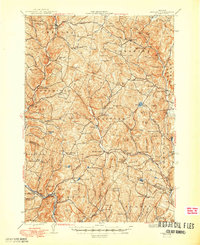
(92)- 1906 Map of Hanover, 1956 Print
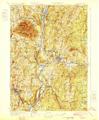
 1906 Hanover1956 Print · USGSThe Upper Connecticut River Valley at the turn of the century is a hub of rail activity and collegiate life. Researchers can trace the early footprints of Dartmouth College or locate vanished rail infrastructure at White River Junction and Deweys Mills.2 unique versions available
 - 1908 Map of Hanover
 1908 Hanover1908 Print · USGSThe Upper Valley at the dawn of the twentieth century was a vital junction of Vermont and New Hampshire rail lines and river commerce. Researchers can trace the early layout of Dartmouth College, the rail yards of White River Junction, and numerous rural schoolhouses like Podunk School.7 unique versions available
 - 1911 Map of Woodstock, 1958 Print
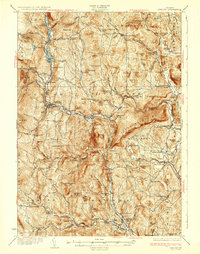
 1911 Woodstock1958 Print · USGSWindsor County villages and mountain hollows are captured here at the dawn of the twentieth century. Researchers can trace the early path of the Woodstock Railroad or locate family sites near the Town Farm and Plymouth Notch.
 - 1913 Map of Woodstock
 1913 Woodstock1913 Print · USGSWindsor County villages and narrow valley settlements are captured here in the decade before the First World War. Genealogists can trace family lines through numerous rural schoolhouses like Mendall School and early post offices at Bridgewater Center Briggs P O.5 unique versions available
 - 1915 Map of Rochester, 1963 Print
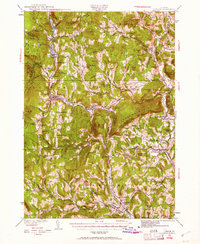
 1915 Rochester1963 Print · USGSThe Green Mountains in the early twentieth century were a landscape of remote hollow schools and narrow valley settlements. Genealogists and historians can trace old property lines and landmarks like the Williams Mine, Hancock Tunnel, and the Texas School.
 - 1917 Map of Rochester
 1917 Rochester1917 Print · USGSThe Green Mountains in the mid-1910s reveal a network of isolated valley settlements and high-altitude gaps. Genealogists and hikers can trace old mountain schools like Corner School and remote landmarks such as Bingo Camp and the Hancock Tunnel.5 unique versions available
 - 1919 Map of Royalton
 1919 Royalton1919 Print · USGSCentral Vermont in the aftermath of the Great War reveals a landscape of thriving hill farms and river-valley rail towns. Genealogists can trace family roots through numerous rural landmarks like Waldo Corners, Wilson School, and the Central Vermont R.R. corridor.
 - 1924 Map of Randolph
 1924 Randolph1924 Print · USGSMid-Vermont in the mid-1920s shows a landscape of river-valley commerce and mountain quarrying along the Central Vermont line. Genealogists can trace dozens of rural schoolhouses like Lost Nation School and Old Stone School, or locate the Bethel Granite Quarry.
 - 1926 Map of Randolph
 1926 Randolph1926 Print · USGSCentral Vermont in the mid-1920s was a landscape of river-valley rail hubs and upland hill farms. Genealogists can trace family names through dozens of schoolhouses like the Old Stone School or locate industrial sites like the Bethel Granite Quarry.5 unique versions available
 - 1926 Map of Claremont, 1955 Print
 1926 Claremont1955 Print · USGSThe Connecticut River valley thrives in the mid-twenties as a hub of industry and transit between Vermont and New Hampshire. Tracing these hills reveals historic crossings like Cornish Bridge, the Sullivan County Farm, and the early Claremont Airport.
 - 1927 Map of Bellows Falls
 1927 Bellows Falls1927 Print · USGSThe borderlands of the Connecticut River valley are captured in the late 1920s, showing the vital rail links between Vermont and New Hampshire. Genealogists and local historians can trace rural schoolhouse districts like Mica Mine Sch, the grounds of the Kern-Hattin Home, and the layout of Westmoreland Depot.4 unique versions available
 - 1927 Map of Mascoma, 1957 Print
 1927 Mascoma1957 Print · USGSGrafton County's hill towns and valleys are caught in detail during the late 1920s, showing the settled character of the New Hampshire interior. Genealogists can trace family names through landmarks like Washburn Corner or locate the distinctive Lower Shaker Village and Upper Shaker Village.3 unique versions available
 - 1928 Map of Ludlow
 1928 Ludlow1928 Print · USGSWindsor County's industrial river valleys and upland hill farms are captured here in the late twenties just as early aviation arrived. Trace family roots through numerous district schools like Baltimore Sch and vanished post offices at Peaseville.
 - 1929 Map of Claremont
 1929 Claremont1929 Print · USGSThe Upper Connecticut River Valley thrives in the late twenties as a hub of manufacturing and mountain farming. You can trace early rail-and-river industrial sites at Claremont and Windsor, or locate ancestral rural schoolhouses like Brick Sch and Red Sch.4 unique versions available
 - 1929 Map of Ludlow, 1961 Print
 1929 Ludlow1961 Print · USGSThe Black River valley and its busy rail corridor define this Vermont landscape in the late 1920s. Researchers can trace the legacy of rural education at Sawyer Stand Sch and locate vanished local landmarks like Baileys Mills or Grout Cem.2 unique versions available
 - 1930 Map of Saxtons River
 1930 Saxtons River1930 Print · USGSWindham County villages were still centers of rural life in the late 1920s as the Rutland RR steamed through the river valleys. Genealogists and historians can locate dozens of local schoolhouses like Round Sch (Dist No 1) and Walker Sch or trace family lands near Grafton and Newfane.2 unique versions available
 - 1930 Map of Bellows Falls
 1930 Bellows Falls1930 Print · USGSThe Connecticut River valley thrives between Vermont and New Hampshire in the late twenties, anchored by the rail hub at Bellows Falls. Researchers can trace old district schools like Derry Hill Sch and find family-named landmarks such as Dodge Tavern.7 unique versions available
 - 1931 Map of Mt. Cube
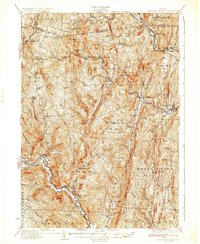
 1931 Mt. Cube1931 Print · USGSThe Connecticut River valley and the foothills of the White Mountains are shown here as they appeared in the early 1930s. Genealogists and hikers can trace the Appalachian Trail, locate rural schools like Blood Brook Sch, or find family sites near Quinttown.3 unique versions available
 - 1932 Map of Mascoma
 1932 Mascoma1932 Print · USGSGrafton County in the early thirties shows a unique landscape of communal settlements and rugged upland farms. Genealogists can trace family roots through numerous local schoolhouses and rural hamlets like Hanover Center and Lower Shaker Village.5 unique versions available
 - 1932 Map of Ludlow
 1932 Ludlow1932 Print · USGSWindsor County in the early thirties features a landscape of mountain hamlets and busy river valleys connected by the Rutland Railroad. Trace genealogy and local history through numerous rural landmarks like Plymouth Kingdom, Baileys Mills, and the Sawyer Stand School.4 unique versions available
 - 1933 Map of Mt. Cube
 1933 Mt. Cube1933 Print · USGSThe Upper Connecticut River valley is shown in the early thirties, where rail and river networks linked New Hampshire and Vermont. Genealogists and local historians can trace schoolhouses like Stetson Sch, the remote Quinttown settlement, and the historic Mt Cube House.6 unique versions available
 - 1933 Map of Saxtons River
 1933 Saxtons River1933 Print · USGSWindham County villages and upland farms are captured in the early 1930s as the regional economy centered on the river valleys. Genealogists can locate family landmarks like Burgess Cem and numerous district schools including No 12 Sch and Easton Sch.4 unique versions available
 - 1943 Map of Woodstock
 1943 Woodstock1943 Print · USGSWindsor County's high country and river valleys are captured here during the early 1940s, showing a landscape of small hill farms and rural schools. Researchers can locate many former community hubs like English Mills, the Town Farm, and Notown.
 - 1944 Map of Strafford, 1949 Print
 1944 Strafford1949 Print · USGSVermont's mining and rural heritage are frozen in time on this mid-century survey of the hills between the White and Ompompanoosuc Rivers. Genealogists and historians can trace the foundations of Strafford, locate the Joseph Smith Monument, or find industrial sites like the Elizabeth Mine.5 unique versions available
 - 1950 Map of Glens Falls
 1950 Glens Falls1950 Print · USGSThe Adirondacks and the Green Mountains meet in this mid-century survey of the New York and Vermont borderlands. Researchers can trace the industrial rail corridors of the Rutland RR and Delaware & Hudson RR connecting Glens Falls, Rutland, and the shores of Lake George.
Showing maps 1-25 of 92
Top cities of Windsor County
- Hartford historical maps
- Springfield historical maps
- Hartland historical maps
- Norwich historical maps
- Woodstock historical maps
- Royalton historical maps
See more
Frequently asked questions
- What are the different types of historical maps available for Windsor County?
- What is the oldest map of Windsor County?
- Where can I purchase historical maps of Windsor County for my home or office?
- Where can I download high-res historical maps of Windsor County?
- Are there historical topographic maps available for Windsor County?
- Is there historical aerial imagery available for Windsor County?
- Where are historical maps of Windsor County sourced from?