1930s Maps of Windsor County, Vermont
Explore 7 historic maps of Windsor County from the 1930s. These maps offer a rare glimpse into what life looked like during the 1930s — showing old roads, neighborhoods, homes, and landmarks that have changed or disappeared over time.
Whether you're researching your family's past, planning a metal detecting trip, or studying how Windsor County's landscape evolved across the 1930s, these high-resolution maps are a powerful tool for exploring the history of this region.
- Focus on a specific era: All maps on this page are from the 1930s, giving you a focused view of this time period.
- See what’s changed: Compare century-old streets, trails, and buildings to today's modern landscape using overlays and satellite layers.
- Research with precision: Use these maps for genealogy, historical research, land use analysis, or educational projects.
- View, download, or print: Maps are fully viewable online in high resolution, and can be downloaded or printed for your own records.
Start exploring Windsor County's history through authentic maps from the 1930s. This is your window into the past.
Windsor County, VT maps
(7)- 1930 Map of Saxtons River
 1930 Saxtons River1930 Print · USGSWindham County villages were still centers of rural life in the late 1920s as the Rutland RR steamed through the river valleys. Genealogists and historians can locate dozens of local schoolhouses like Round Sch (Dist No 1) and Walker Sch or trace family lands near Grafton and Newfane.2 unique versions available
 - 1930 Map of Bellows Falls
 1930 Bellows Falls1930 Print · USGSThe Connecticut River valley thrives between Vermont and New Hampshire in the late twenties, anchored by the rail hub at Bellows Falls. Researchers can trace old district schools like Derry Hill Sch and find family-named landmarks such as Dodge Tavern.7 unique versions available
 - 1931 Map of Mt. Cube
 1931 Mt. Cube1931 Print · USGSThe Connecticut River valley and the foothills of the White Mountains are shown here as they appeared in the early 1930s. Genealogists and hikers can trace the Appalachian Trail, locate rural schools like Blood Brook Sch, or find family sites near Quinttown.3 unique versions available
 - 1932 Map of Mascoma
 1932 Mascoma1932 Print · USGSGrafton County in the early thirties shows a unique landscape of communal settlements and rugged upland farms. Genealogists can trace family roots through numerous local schoolhouses and rural hamlets like Hanover Center and Lower Shaker Village.5 unique versions available
 - 1932 Map of Ludlow
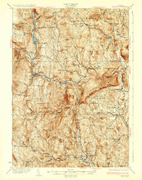 1932 Ludlow1932 Print · USGSWindsor County in the early thirties features a landscape of mountain hamlets and busy river valleys connected by the Rutland Railroad. Trace genealogy and local history through numerous rural landmarks like Plymouth Kingdom, Baileys Mills, and the Sawyer Stand School.4 unique versions available
 - 1933 Map of Mt. Cube
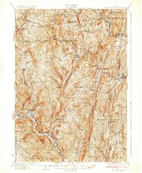
 1933 Mt. Cube1933 Print · USGSThe Upper Connecticut River valley is shown in the early thirties, where rail and river networks linked New Hampshire and Vermont. Genealogists and local historians can trace schoolhouses like Stetson Sch, the remote Quinttown settlement, and the historic Mt Cube House.6 unique versions available
 - 1933 Map of Saxtons River
 1933 Saxtons River1933 Print · USGSWindham County villages and upland farms are captured in the early 1930s as the regional economy centered on the river valleys. Genealogists can locate family landmarks like Burgess Cem and numerous district schools including No 12 Sch and Easton Sch.4 unique versions available
End of results
Showing maps 1-7 of 7
Top cities of Windsor County
- Hartford historical maps
- Springfield historical maps
- Hartland historical maps
- Norwich historical maps
- Woodstock historical maps
- Royalton historical maps
See more
Frequently asked questions
- What are the different types of historical maps available for Windsor County?
- What is the oldest map of Windsor County?
- Where can I purchase historical maps of Windsor County for my home or office?
- Where can I download high-res historical maps of Windsor County?
- Are there historical topographic maps available for Windsor County?
- Is there historical aerial imagery available for Windsor County?
- Where are historical maps of Windsor County sourced from?