1990s Maps of Windsor County, Vermont
Explore 22 historic maps of Windsor County from the 1990s. These maps offer a rare glimpse into what life looked like during the 1990s — showing old roads, neighborhoods, homes, and landmarks that have changed or disappeared over time.
Whether you're researching your family's past, planning a metal detecting trip, or studying how Windsor County's landscape evolved across the 1990s, these high-resolution maps are a powerful tool for exploring the history of this region.
- Focus on a specific era: All maps on this page are from the 1990s, giving you a focused view of this time period.
- See what’s changed: Compare century-old streets, trails, and buildings to today's modern landscape using overlays and satellite layers.
- Research with precision: Use these maps for genealogy, historical research, land use analysis, or educational projects.
- View, download, or print: Maps are fully viewable online in high resolution, and can be downloaded or printed for your own records.
Start exploring Windsor County's history through authentic maps from the 1990s. This is your window into the past.
Windsor County, VT maps
(22)- 1996 Map of Quechee, 2000 Print
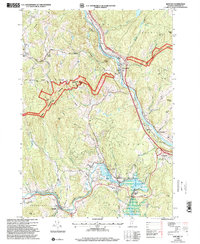 1996 Quechee2000 Print · USGSWindsor County in the late nineties showcases a landscape where the Ottauquechee River meets ancient colonial routes and deep forest preserves. Researchers can trace family history through numerous local sites like Centertown Cem, Deweys Mills, and the Taftsville covered bridge.
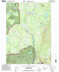
 - 1996 Map of Delectable Mountain, 2000 Print
 1996 Delectable Mountain2000 Print · USGSThe Green Mountain interior of Windsor and Rutland counties comes into focus in this mid-nineties survey of high ridges and deep hollows. Researchers can trace remote locales like Notown, find the Stony Brook Shelter along the trail, and locate landmarks like Lakota Lake.
 - 1996 Map of Enfield, 2001 Print
 1996 Enfield2001 Print · USGSGrafton County during the mid-1990s shows a landscape defined by the rise of Moose Mountain and the sprawling waters of Mascoma Lake. Researchers can trace the heritage of Enfield near the Shaker Bridge or follow the Appalachian Trail through the high woods of the White Mountain National Forest.
 - 1996 Map of Hanover, 2001 Print
 1996 Hanover2001 Print · USGSThe Upper Valley comes to life in the late nineties, centered on the historic academic and industrial hubs along the Connecticut River. Researchers can trace the winding Appalachian Scenic Trail or locate family roots at Hillside Cemetery and St Barnabas Ch.
 - 1996 Map of Lyme, 2001 Print
 1996 Lyme2001 Print · USGSThe Upper Valley river towns of Lyme and Thetford are captured here in the mid-nineties, showing the rural character of the Vermont and New Hampshire border. Researchers can locate family landmarks like the Thetford Academy, the Covered Bridge, and the Wilmot Cem near High Peak.
 - 1997 Map of Ludlow, 1999 Print
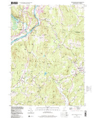
 1997 Ludlow1999 Print · USGSIn the late 1990s, the Black River valley in Windsor County maintained its blend of traditional village life and mountain recreation. Researchers can trace historic cemeteries and civic sites from Pleasant View Cem to the Black River High Sch and the hamlet of Tyson.
 - 1997 Map of Weston, 2000 Print
 1997 Weston2000 Print · USGSWeston and the Green Mountains are shown in the late nineties, capturing a landscape of deep river valleys and high forest ridges. Researchers can trace local landmarks like Weston Priory, the Wantastiquet Trout Club, and the winding Rootbeer Ridge Trail.
 - 1997 Map of Woodstock North, 2000 Print
 1997 Woodstock North2000 Print · USGSWindsor County in the late 1990s showcases a landscape of highland villages and protected wilderness before the modern era. Genealogists and historians can trace family plots at Village Cem or Cushing Cem and locate landmarks like Central Sch and the Appalachian National Scenic Trail.
 - 1997 Map of Rochester, 2000 Print
 1997 Rochester2000 Print · USGSVermont's Green Mountains and river valleys are shown in detail during the late nineties, capturing a transition toward forest recreation and local heritage. Researchers can trace historic sites like the CCC Camp Interpretive Site, St Dennis Ch, and the hamlets of Talcville and Jerusalem.
 - 1997 Map of Killington Peak, 2000 Print
 1997 Killington Peak2000 Print · USGSRutland County’s high peaks and forest lands are documented here during the late 1990s as the region solidified its role as a premier recreation destination. Genealogists and local historians can trace the foundations of North Shrewsbury through the Northam Sch and Northam Cem.
 - 1997 Map of Londonderry, 2000 Print
 1997 Londonderry2000 Print · USGSThe West River valley in the late nineties shows a landscape balancing its mountain heritage with a growing winter sports industry. Genealogists and historians can trace family plots at Brooks Cem and Glebe View Cem or locate the site of the former Winhall Station.
 - 1997 Map of Mount Holly, 2000 Print
 1997 Mount Holly2000 Print · USGSMount Holly and the Green Mountains are shown during the late twentieth century as recreation and conservation shaped the Vermont landscape. Genealogists can trace family names at Hammond Hill and Roger Hill, or locate local burials at various Cem sites near Belmont and Hortonville.
 - 1997 Map of Mount Carmel, 2000 Print
 1997 Mount Carmel2000 Print · USGSRutland County's high ridges were meticulously mapped in the late nineties, documenting the intersection of the Green Mountain National Forest and local town boundaries. Researchers can trace remote mountain graveyards like Wetmore Cem and Bump Cem or locate early wilderness landmarks such as The Great Cliff and Boiling Spring.
 - 1997 Map of Hancock, 2000 Print
 1997 Hancock2000 Print · USGSThe White River valley in central Vermont appears here in the late nineties, showing the vital road links between Granville and Hancock. Researchers can locate several family burial sites including Elmwood Cem and South Hollow Cem, or trace the remote Boyden Trail.
 - 1997 Map of Bread Loaf, 2000 Print
 1997 Bread Loaf2000 Print · USGSThe Green Mountains of Addison and Windsor Counties are shown here at the close of the twentieth century, detailing a landscape of high peaks and deep wilderness. Researchers can locate remote landmarks like Worth Mountain Lodge, the Middlebury College Snow Bowl, and isolated mountain shelters along the Long Trail.
 - 1997 Map of Pico Peak, 2000 Print
 1997 Pico Peak2000 Print · USGSVermont's high Green Mountains are captured in the late nineties, documenting a landscape defined by winter recreation and wilderness conservation. Genealogists and hikers can trace the Appalachian National Scenic Trail past the South Hill Cem and into the Pico Peak Winter Sports Area.
 - 1998 Map of North Hartland
 1998 North Hartland1998 Print · USGSThe Connecticut River valley along the Vermont and New Hampshire border comes to life in this late-century survey. Researchers can trace family history through sites like Kimball Union Academy and numerous burial grounds such as Plainfield Cem and Raynes-Ford Cem.
 - 1998 Map of Hartland, 1999 Print
 1998 Hartland1999 Print · USGSLate twentieth-century Windsor County reveals a landscape of high hills and river junctions along the New Hampshire border. Genealogists can trace family names across Hoisington Cem, Aldrich Cem, and historic hamlets like Quakers Village.
 - 1998 Map of Woodstock South, 1999 Print
 1998 Woodstock South1999 Print · USGSWindsor County, Vermont, retained its classic New England character in the late nineties, from the river valleys to the high state forest peaks. Researchers can trace family history through many small burial sites like Riverside Cemetery or explore the transit history found at the Covered Bridge and Reading Center.
 - 1998 Map of Springfield, 2002 Print
 1998 Springfield2002 Print · USGSThe Connecticut River valley at the close of the twentieth century shows a region of industrial towns and conserved forests. Researchers can trace local genealogy and rail history through Eureka Cem, the Claremont & Concord RR, and Goulds Mill.
 - 1998 Map of Windsor, 2002 Print
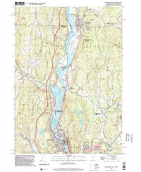
 1998 Windsor2002 Print · USGSWindsor and the Connecticut River Valley are captured here in the late nineties, showing the region's transition between conserved highlands and riverfront industry. Trace local landmarks like the Cornish Bridge, the Central Vermont rail line, and the slopes of Mt Ascutney.
 - 1998 Map of Bellows Falls, 2002 Print
 1998 Bellows Falls2002 Print · USGSThe borderlands of Vermont and New Hampshire come alive in the 1990s as the river economy transitions toward modern infrastructure. Trace family names and landmarks from Bellows Falls to Charlestown, finding sites like Bates Mill Pond and the Mt Kilburn Tower.
End of results
Showing maps 1-22 of 22
Top cities of Windsor County
- Hartford historical maps
- Springfield historical maps
- Hartland historical maps
- Norwich historical maps
- Woodstock historical maps
- Royalton historical maps
See more
Frequently asked questions
- What are the different types of historical maps available for Windsor County?
- What is the oldest map of Windsor County?
- Where can I purchase historical maps of Windsor County for my home or office?
- Where can I download high-res historical maps of Windsor County?
- Are there historical topographic maps available for Windsor County?
- Is there historical aerial imagery available for Windsor County?
- Where are historical maps of Windsor County sourced from?