1900s (20th Century) Maps of Scottsville, Virginia
Explore 13 historic maps of Scottsville from the 1900s (20th Century). These maps offer a rare glimpse into what life looked like during the 1900s — showing old roads, neighborhoods, homes, and landmarks that have changed or disappeared over time.
Whether you're researching your family's past, planning a metal detecting trip, or studying how Scottsville's landscape evolved across the 1900s, these high-resolution maps are a powerful tool for exploring the history of this region.
- Focus on a specific era: All maps on this page are from the 1900s, giving you a focused view of this time period.
- See what’s changed: Compare century-old streets, trails, and buildings to today's modern landscape using overlays and satellite layers.
- Research with precision: Use these maps for genealogy, historical research, land use analysis, or educational projects.
- View, download, or print: Maps are fully viewable online in high resolution, and can be downloaded or printed for your own records.
Start exploring Scottsville's history through authentic maps from the 1900s. This is your window into the past.
Scottsville, VA maps
(13)- 1929 Map of Covesville
 1929 Covesville1929 Print · USGSAlbemarle County’s soapstone industry and mountain communities are frozen in time just before the Depression. Genealogists and historians can trace family locations near Alberene, old schools like Red Hill Sch, and landmarks including Forest Lodge and Johnson Mill.3 unique versions available
 - 1935 Map of Covesville, 1961 Print
 1935 Covesville1961 Print · USGSMid-century Albemarle County was defined by its soapstone industry and a dense network of country schools and chapels. Genealogists and historians can trace the foundations of local life through landmarks like Albermarle Soapstone Company, Cedar Vale Sch, and the riverside hub of Scottsville.
 - 1943 Map of Scottsville, 1969 Print
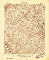
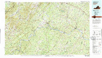
 1943 Scottsville1969 Print · USGSCentral Virginia’s river valleys and historic estates are preserved in this mid-century portrait of the Albemarle and Fluvanna borderlands. Researchers can trace ancestral locations at Ash Lawn, follow the Chesapeake and Ohio line through Nicholas Siding, or locate rural landmarks like Jefferson Mill.
 - 1945 Map of Covesville
 1945 Covesville1945 Print · USGSAlbemarle County's river valleys and mountain foothills are shown here in the mid-1940s, a period defined by the convergence of rail and river commerce. Genealogists and historians can trace family locations near Alberene, Esmont, and the Mt Zion Ch, or locate old industrial sites like Johnson Mill.
 - 1946 Map of Scottsville
 1946 Scottsville1946 Print · USGSCentral Virginia during the mid-1940s is shown here as a landscape of river-bend towns and quiet country crossroads. Genealogists and historians can trace family locations through named landmarks like Jefferson Mill, Blenheim, and Antioch Ch, or follow the historic Three Chopt Road.2 unique versions available
 - 1947 Map of Roanoke, 1948 Print
 1947 Roanoke1948 Print · USGSCentral Virginia in the late 1940s reveals a region defined by its great mountain ridges and the powerful river-and-rail economy connecting Roanoke to Lynchburg. Researchers can trace the path of the Virginian RR and locate historic county seats like Charlotte Court House.2 unique versions available
 - 1959 Map of Roanoke
 1959 Roanoke1959 Print · USGSCentral Virginia and the Blue Ridge appear in great detail during the late fifties, showcasing the transition from mountain industry to Piedmont farmland. Trace the path of the Norfolk and Western railroad or find old river towns like Appomattox and Amelia Court House.
 - 1963 Map of Roanoke
 1963 Roanoke1963 Print · USGSCentral Virginia and the Blue Ridge front appear here in the early sixties, caught between their deep railroad roots and new postwar developments. Genealogists and historians can trace the rail lines of the Norfolk and Western through towns like Bedford and Altavista, or locate family landmarks near Smith Mountain Lake.
 - 1967 Map of Esmont, 1968 Print
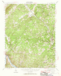
 1967 Esmont1968 Print · USGSAlbemarle County's Piedmont landscape is captured here in the late sixties, showing the vital river-and-rail corridor along the southern border. Genealogists and local historians can trace family locations near Esmont, Keene, and Scottsville, or find local landmarks like Yancy Sch and Dawson Mill.3 unique versions available
 - 1967 Map of Scottsville, 1969 Print
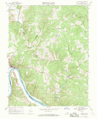 1967 Scottsville1969 Print · USGSThe James River region at the end of the 1960s reveals a landscape defined by sharp river bends and industrial heritage. Genealogists and historians can trace family locations near Scottsville, Jefferson Mill, and rural landmarks like Fox Memorial Ch.2 unique versions available
 - 1971 Map of Roanoke, 1977 Print
 1971 Roanoke1977 Print · USGSThe Virginia Piedmont and Blue Ridge mountains meet in this early 1970s landscape of river valleys and rail hubs. Researchers can trace historic transportation routes and landmarks like the Appomattox Court House Nat Hist Pk, the Peaks of Otter, and Amelia Court House.2 unique versions available
 - 1979 Map of Dillwyn, 1982 Print
 1979 Dillwyn1982 Print · USGSCentral Virginia in the late seventies is defined by the winding James River and the rural communities of the Piedmont. Trace old transportation corridors and family-named ridges from Dillwyn and Buckingham to the Blue Ridge foothills.
 - 1979 Map of Esmont, 1982 Print
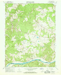
 1979 Esmont1982 Print · USGSSouthern Albemarle County is captured in the late seventies, showing the rural landscape between the James River and the Piedmont hills. Researchers can trace land use around Esmont, Scottsville, and the riverside settlement of Warren.
End of results
Showing maps 1-13 of 13
Top cities near Scottsville
- Charlottesville historical maps
- Lake Monticello historical maps
- Pantops historical maps
- Rivanna historical maps
- North Garden historical maps
- Keswick historical maps
Top neighborhoods of Scottsville
Frequently asked questions
- What are the different types of historical maps available for Scottsville?
- What is the oldest map of Scottsville?
- Where can I purchase historical maps of Scottsville for my home or office?
- Where can I download high-res historical maps of Scottsville?
- Are there historical topographic maps available for Scottsville?
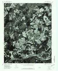
- Is there historical aerial imagery available for Scottsville?
- Where are historical maps of Scottsville sourced from?