2000-2009 Maps of Buchanan County, Virginia
Explore 4 historic maps of Buchanan County from 2000-2009. These maps offer a rare glimpse into what life looked like during the 2000s — showing old roads, neighborhoods, homes, and landmarks that have changed or disappeared over time.
Whether you're researching your family's past, planning a metal detecting trip, or studying how Buchanan County's landscape evolved across the 2000s, these high-resolution maps are a powerful tool for exploring the history of this region.
- Focus on a specific era: All maps on this page are from the 2000s, giving you a focused view of this time period.
- See what’s changed: Compare century-old streets, trails, and buildings to today's modern landscape using overlays and satellite layers.
- Research with precision: Use these maps for genealogy, historical research, land use analysis, or educational projects.
- View, download, or print: Maps are fully viewable online in high resolution, and can be downloaded or printed for your own records.
Start exploring Buchanan County's history through authentic maps from the 2000s. This is your window into the past.
Buchanan County, VA maps
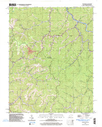
(4)- 2001 Map of Majestic, 2003 Print
 2001 Majestic2003 Print · USGSThe Central Appalachian coalfields come into focus at the turn of the millennium where the TUG FORK separates Kentucky and West Virginia. Genealogists and industrial historians can trace riverside settlements like Vulcan, Devon, and Majestic, alongside the NORFOLK AND WESTERN rail line.
 - 2001 Map of Panther, 2003 Print
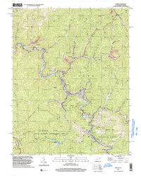
 2001 Panther2003 Print · USGSPanther and the Tug river valley are captured here at the turn of the century as coal and rail still define the McDowell County landscape. Genealogists can trace family heritage through dozens of local burial sites including Sullivan Cem and Lester Cem.
 - 2001 Map of War, 2003 Print
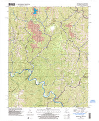
 2001 War2003 Print · USGSMcDowell County's mining and mountain communities are captured here just after the turn of the millennium. Trace the industrial and family history of War, Berwind, and Bartley while following old routes along the Dry Fork.
 - 2001 Map of Wharncliffe, 2003 Print
 2001 Wharncliffe2003 Print · USGSThe coal country of Mingo County is captured at the turn of the millennium, showing a landscape defined by industrial mines and river-bottom settlements. Genealogists can trace family locations near Wharncliffe, War Eagle, and the Hardy Union Ch.
End of results
Showing maps 1-4 of 4
Top cities of Buchanan County
Frequently asked questions
- What are the different types of historical maps available for Buchanan County?
- What is the oldest map of Buchanan County?
- Where can I purchase historical maps of Buchanan County for my home or office?
- Where can I download high-res historical maps of Buchanan County?
- Are there historical topographic maps available for Buchanan County?
- Is there historical aerial imagery available for Buchanan County?
- Where are historical maps of Buchanan County sourced from?