1970s Maps of Caroline County, Virginia
Explore 3 historic maps of Caroline County from the 1970s. These maps offer a rare glimpse into what life looked like during the 1970s — showing old roads, neighborhoods, homes, and landmarks that have changed or disappeared over time.
Whether you're researching your family's past, planning a metal detecting trip, or studying how Caroline County's landscape evolved across the 1970s, these high-resolution maps are a powerful tool for exploring the history of this region.
- Focus on a specific era: All maps on this page are from the 1970s, giving you a focused view of this time period.
- See what’s changed: Compare century-old streets, trails, and buildings to today's modern landscape using overlays and satellite layers.
- Research with precision: Use these maps for genealogy, historical research, land use analysis, or educational projects.
- View, download, or print: Maps are fully viewable online in high resolution, and can be downloaded or printed for your own records.
Start exploring Caroline County's history through authentic maps from the 1970s. This is your window into the past.
Caroline County, VA maps
(3)- 1972 Map of Passapatanzy, 1974 Print
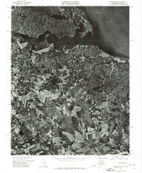 1972 Passapatanzy1974 Print · USGSCoastal Virginia in the early seventies is revealed here through detailed aerial imagery of the peninsula between two great rivers. Trace the rural development around Passapatanzy and study the shoreline details along Potomac Creek and the Rappahannock River.
 - 1973 Map of Richmond, 1974 Print
 1973 Richmond1974 Print · USGSThe Virginia Tidewater and Piedmont come alive in the early seventies, showcasing a region defined by its great rivers and massive military installations. Researchers can trace the mid-century growth of Richmond or locate family sites near Amelia Court House and Highland Springs.2 unique versions available
 - 1973 Map of Lake Anna East, 1975 Print
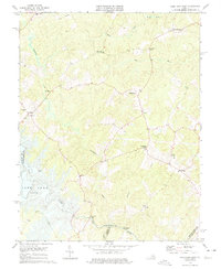 1973 Lake Anna East1975 Print · USGSSpotsylvania County in the early seventies shows the rural crossroads and river crossings before modern development reached the banks of the North Anna. Genealogists can locate family landmarks like Duerson Store, Levy, and the Livingston Sch.4 unique versions available
End of results
Showing maps 1-3 of 3
Top cities of Caroline County
- Lake Land'Or historical maps
- Lake Caroline historical maps
- Bowling Green historical maps
- Port Royal historical maps
Frequently asked questions
- What are the different types of historical maps available for Caroline County?
- What is the oldest map of Caroline County?
- Where can I purchase historical maps of Caroline County for my home or office?
- Where can I download high-res historical maps of Caroline County?
- Are there historical topographic maps available for Caroline County?
- Is there historical aerial imagery available for Caroline County?
- Where are historical maps of Caroline County sourced from?