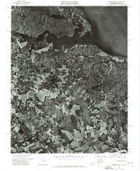
1972 Map of Passapatanzy
USGS Topo · Published 1974About this map
The settlement of Passapatanzy sits at the heart of this orthophotoquad, which captures the distinct land-use patterns of King George County during the early 1970s. This specialized survey, produced through aerial photography taken in April 1972, reveals a landscape defined by the convergence of major waterways. The north is dominated by the broad Potomac River and the winding inlet of Potomac Creek, while the southern edge of the sheet follows the meandering course of the Rappahannock River. Unlike standard topographic maps, this imagery provides a direct look at the distribution of agricultural fields and dense woodlands, showing how the rural community of Passapatanzy remained largely agrarian and tied to the peninsula's natural drainage systems.
Find a feature on this map
4 named features on this map. Tap any name to fly to it.
Don’t see what you’re looking for? This feature index may not catch every label — zoom into the map to look around manually.
Map Details
Editions of this 1972 Passapatanzy Map
This is the sole edition of this map. No revisions or reprints were ever made.
Other maps of this area

1889 · Fredericksburg
USGS Topo · 1:125,000

1892 · Fredericksburg
USGS Topo · 1:125,000

1894 · Fredericksburg
USGS Topo · 1:125,000

1913 · Nanjemoy
USGS Topo · 1:62,500

1926 · Stafford
USGS Topo · 1:62,500

1931 · Stafford
USGS Topo · 1:62,500

1942 · Guinea
USGS Topo · 1:31,680

1942 · Port Royal
USGS Topo · 1:31,680

1942 · Rappahannock Academy
USGS Topo · 1:31,680
1943 · Fredericksburg
USGS Topo · 1:24,000