1900s (20th Century) Maps of Pyletown, Virginia
Explore 12 historic maps of Pyletown from the 1900s (20th Century). These maps offer a rare glimpse into what life looked like during the 1900s — showing old roads, neighborhoods, homes, and landmarks that have changed or disappeared over time.
Whether you're researching your family's past, planning a metal detecting trip, or studying how Pyletown's landscape evolved across the 1900s, these high-resolution maps are a powerful tool for exploring the history of this region.
- Focus on a specific era: All maps on this page are from the 1900s, giving you a focused view of this time period.
- See what’s changed: Compare century-old streets, trails, and buildings to today's modern landscape using overlays and satellite layers.
- Research with precision: Use these maps for genealogy, historical research, land use analysis, or educational projects.
- View, download, or print: Maps are fully viewable online in high resolution, and can be downloaded or printed for your own records.
Start exploring Pyletown's history through authentic maps from the 1900s. This is your window into the past.
Pyletown, VA maps
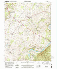
(12)- 1938 Map of Winchester
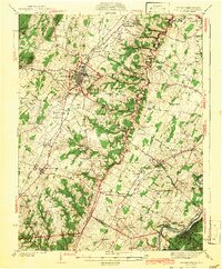
 1938 Winchester1938 Print · USGSThe Shenandoah Valley appears here in the late 1930s as a vital crossroads of rail and road. Genealogists and historians can trace old homesteads and landmarks like Greenway Court, the Civil War-era Star Fort, and Berrys Ferry Bridge.
 - 1942 Map of Winchester
 1942 Winchester1942 Print · USGSThe Shenandoah Valley during the early years of the war shows a landscape of busy pikes and vital rail junctions. Researchers can trace historic fortifications like Star Fort, family sites at Ridings Mill, and landmarks like Greenway Court.3 unique versions available
 - 1948 Map of Cumberland
 1948 Cumberland1948 Print · USGSMid-century Appalachia and the Shenandoah Valley are shown in detail, documenting the industrial and transportation hubs of the tri-state area. Genealogists can trace family roots through settlements like Double Tollgate and Bunker Hill or along the Baltimore & Ohio RR.3 unique versions available
 - 1952 Map of Cumberland
 1952 Cumberland1952 Print · USGSThe Potomac Highlands and the Shenandoah Valley are revealed in this early 1950s survey of the Appalachian interior. Researchers can trace the river-and-rail corridors connecting Cumberland, Winchester, and the recreational waters of Deep Creek Lake.
 - 1956 Map of Cumberland, 1966 Print
 1956 Cumberland1966 Print · USGSThe tri-state Highlands in the mid-1950s show a landscape shaped by coal, timber, and the massive presence of the Baltimore & Ohio RR. Researchers can trace the industrial corridor from Cumberland through the Allegheny Mountains to mountain retreats like Deep Creek Lake.6 unique versions available
 - 1957 Map of Cumberland
 1957 Cumberland1957 Print · USGSThe Potomac River valley and the ridges of the Allegheny Front define this mid-century landscape at the intersection of Maryland, West Virginia, and Pennsylvania. Trace the steam-era rail lines of the Baltimore and Ohio RR or locate rural landmarks like St Stephens Church and Stony River Dam.
 - 1961 Map of Cumberland
 1961 Cumberland1961 Print · USGSThe tri-state highlands of Maryland, West Virginia, and Pennsylvania are shown in the mid-twentieth century as a complex landscape of ridges and river valleys. Researchers can trace the winding Potomac River and find old rail-and-river towns like Cumberland, Keyser, and Morgantown.
 - 1962 Map of Cumberland
 1962 Cumberland1962 Print · USGSThe central Appalachians meet at the height of the mid-century industrial era, showing the rugged topography between Morgantown and Winchester. Genealogists can trace family lands near Fort Necessity or along the vital Baltimore & Ohio RR corridors.
 - 1966 Map of Boyce, 1967 Print
 1966 Boyce1967 Print · USGSThe Shenandoah Valley in the 1960s remains a landscape of historic estates and river islands. Researchers can trace family sites near White Post, the grounds of Carter Hall, and landmark river features like Robinson Crusoe Island.3 unique versions available
 - 1972 Map of Boyce, 1977 Print
 1972 Boyce1977 Print · USGSThe rural Virginia landscape of the early seventies is revealed in this aerial study centered on Clarke County. Genealogists and local historians can trace property lines and the village layouts of Boyce and Millwood near the winding Shenandoah River.
 - 1983 Map of Winchester, 1985 Print
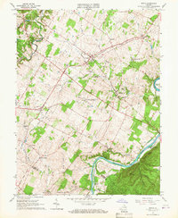
 1983 Winchester1985 Print · USGSThe northern Shenandoah Valley and the rugged West Virginia borderlands are captured here in the early eighties. Researchers can trace the rail networks of the B & O RR and find local landmarks like Potomac State College, Three Churches, and the Old Iron Furnace.3 unique versions available
 - 1999 Map of Boyce, 2001 Print
 1999 Boyce2001 Print · USGSClarke County's estate country is shown here in the late twentieth century as it appeared before modern suburban expansion. Genealogists and researchers can trace family landmarks like Carter Hall, White Post, and the river islands of Hardin Island and Treasure Island.
End of results
Showing maps 1-12 of 12
Top cities near Pyletown
- Winchester historical maps
- Front Royal historical maps
- Charles Town historical maps
- Ranson historical maps
- Berryville historical maps
- Shenandoah Farms historical maps
See more
Frequently asked questions
- What are the different types of historical maps available for Pyletown?
- What is the oldest map of Pyletown?
- Where can I purchase historical maps of Pyletown for my home or office?
- Where can I download high-res historical maps of Pyletown?
- Are there historical topographic maps available for Pyletown?
- Is there historical aerial imagery available for Pyletown?
- Where are historical maps of Pyletown sourced from?