1920s Maps of Craig County, Virginia
Explore 4 historic maps of Craig County from the 1920s. These maps offer a rare glimpse into what life looked like during the 1920s — showing old roads, neighborhoods, homes, and landmarks that have changed or disappeared over time.
Whether you're researching your family's past, planning a metal detecting trip, or studying how Craig County's landscape evolved across the 1920s, these high-resolution maps are a powerful tool for exploring the history of this region.
- Focus on a specific era: All maps on this page are from the 1920s, giving you a focused view of this time period.
- See what’s changed: Compare century-old streets, trails, and buildings to today's modern landscape using overlays and satellite layers.
- Research with precision: Use these maps for genealogy, historical research, land use analysis, or educational projects.
- View, download, or print: Maps are fully viewable online in high resolution, and can be downloaded or printed for your own records.
Start exploring Craig County's history through authentic maps from the 1920s. This is your window into the past.
Craig County, VA maps
(4)- 1921 Map of Ronceverte
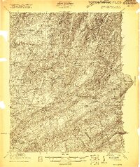 1921 Ronceverte1921 Print · USGSThe West Virginia and Virginia borderlands come alive in this early 1920s record of the Greenbrier Valley and Allegheny ridges. Genealogists can trace family roots through numerous local landmarks like Organ Cave, Red Mill, and the Highland Green School.2 unique versions available
 - 1923 Map of Ronceverte
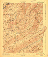 1923 Ronceverte1923 Print · USGSSoutheast West Virginia in the early twenties is a landscape of mountain ridges and remote hollows. Genealogists can trace the rural communities of Gap Mills and Sweet Springs, alongside dozens of landmarks like Organ Cave and Schley School.4 unique versions available
 - 1923 Map of Waiteville
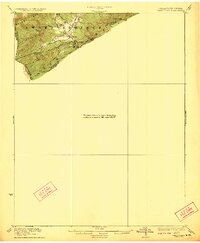 1923 Waiteville1923 Print · USGSThe mountain border between West Virginia and Virginia comes to life in the early 1920s, centered on the settlement of Waiteville. Local historians can trace the Norfolk and Western Ry line as it snakes along Potts Cr beneath Peters Mountain.2 unique versions available
 - 1929 Map of Salem
 1929 Salem1929 Print · USGSThe Roanoke River valley and surrounding mountain ridges are captured here in the late 1920s as the railroad and highway networks expanded. Genealogists and researchers can trace local landmarks like Catawba Sanatorium, Webb Mill, and old schoolhouses including Rubles Sch.2 unique versions available
End of results
Showing maps 1-4 of 4
Top cities of Craig County
Frequently asked questions
- What are the different types of historical maps available for Craig County?
- What is the oldest map of Craig County?
- Where can I purchase historical maps of Craig County for my home or office?
- Where can I download high-res historical maps of Craig County?
- Are there historical topographic maps available for Craig County?
- Is there historical aerial imagery available for Craig County?
- Where are historical maps of Craig County sourced from?