1940s Maps of New Baltimore, Virginia
Explore 7 historic maps of New Baltimore from the 1940s. These maps offer a rare glimpse into what life looked like during the 1940s — showing old roads, neighborhoods, homes, and landmarks that have changed or disappeared over time.
Whether you're researching your family's past, planning a metal detecting trip, or studying how New Baltimore's landscape evolved across the 1940s, these high-resolution maps are a powerful tool for exploring the history of this region.
- Focus on a specific era: All maps on this page are from the 1940s, giving you a focused view of this time period.
- See what’s changed: Compare century-old streets, trails, and buildings to today's modern landscape using overlays and satellite layers.
- Research with precision: Use these maps for genealogy, historical research, land use analysis, or educational projects.
- View, download, or print: Maps are fully viewable online in high resolution, and can be downloaded or printed for your own records.
Start exploring New Baltimore's history through authentic maps from the 1940s. This is your window into the past.
New Baltimore, VA maps
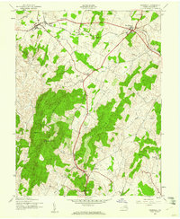
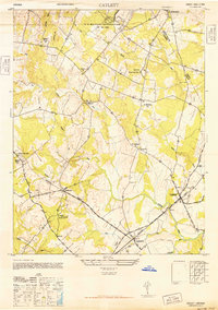
(7)- 1943 Map of Catlett, 1955 Print
 1943 Catlett1955 Print · USGSMid-century Fauquier and Prince William counties center on the Southern Railway as it links rural hubs and farming estates. Genealogists can trace family footprints across dozens of local landmarks, from Vint Hill Farm to Dunkard Church and Balls Mill.2 unique versions available
 - 1943 Map of Thorofare Gap, 1960 Print
 1943 Thorofare Gap1960 Print · USGSNorthern Virginia at the height of the Second World War shows a landscape defined by the ridgeline of the Bull Run Mountains. Genealogists and local historians can trace the foundations of communities like Haymarket and Buckland or locate specific sites like Beverly Mills and Vint Hill Farm Military Reservation.
 - 1943 Map of Marshall, 1961 Print
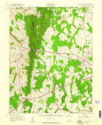
 1943 Marshall1961 Print · USGSUpper Fauquier County is captured during the early 1940s, showing the agricultural heartland between the Water Mountains and Pignut Mountain. Genealogists and historians can trace the foundations of Marshall and The Plains, locating local landmarks like School No 18 and the Fairgrounds.
 - 1944 Map of Thorofare Gap
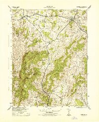
 1944 Thorofare Gap1944 Print · USGSPrince William and Fauquier counties are shown here during the Second World War as the region’s strategic gaps and rail lines remained vital to Virginia's interior. Genealogists and researchers can trace rural landmarks from Vint Hill Farm to Beverly Mills and St Pauls Ch.
 - 1944 Map of Marshall
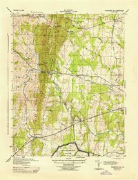
 1944 Marshall1944 Print · USGSFauquier County at the height of the Second World War remains a landscape of rail-connected villages and mountain ridges. Genealogists and local historians can trace rural school locations like Public School No 18 and Bethel School or landmarks like the Fair Grounds.
 - 1946 Map of Catlett
 1946 Catlett1946 Print · USGSFauquier County's rural landscape is captured here in the years following World War II, centered on the rail stops and country crossroads that defined local life. Trace the historic Southern Railway line through Casanova and Calverton or locate sites like the Rosenwald Sch and Vint Hill Farm.
 - 1948 Map of Washington
 1948 Washington1948 Print · USGSThe Potomac and Chesapeake regions in the late 1940s reveal a landscape of expanding military reach and deep-rooted Tidewater settlements. Trace old rail corridors like the Richmond Fredericksburg & Potomac RR or locate landmarks like the Wakefield Washington Monument and St. Marys College.2 unique versions available
End of results
Showing maps 1-7 of 7
Top cities near New Baltimore
- Linton Hall historical maps
- South Riding historical maps
- Sudley historical maps
- Gainesville historical maps
- Bull Run historical maps
- Stone Ridge historical maps
See more
Top neighborhoods of New Baltimore
- Vint Hill Farms historical maps
- Jamison's Farm historical maps
- Lakewood historical maps
- Snow Hill historical maps
- Lakeway historical maps
- Brookside historical maps
See more
Frequently asked questions
- What are the different types of historical maps available for New Baltimore?
- What is the oldest map of New Baltimore?
- Where can I purchase historical maps of New Baltimore for my home or office?
- Where can I download high-res historical maps of New Baltimore?
- Are there historical topographic maps available for New Baltimore?
- Is there historical aerial imagery available for New Baltimore?
- Where are historical maps of New Baltimore sourced from?