1990s Maps of New Baltimore, Virginia
Explore 2 historic maps of New Baltimore from the 1990s. These maps offer a rare glimpse into what life looked like during the 1990s — showing old roads, neighborhoods, homes, and landmarks that have changed or disappeared over time.
Whether you're researching your family's past, planning a metal detecting trip, or studying how New Baltimore's landscape evolved across the 1990s, these high-resolution maps are a powerful tool for exploring the history of this region.
- Focus on a specific era: All maps on this page are from the 1990s, giving you a focused view of this time period.
- See what’s changed: Compare century-old streets, trails, and buildings to today's modern landscape using overlays and satellite layers.
- Research with precision: Use these maps for genealogy, historical research, land use analysis, or educational projects.
- View, download, or print: Maps are fully viewable online in high resolution, and can be downloaded or printed for your own records.
Start exploring New Baltimore's history through authentic maps from the 1990s. This is your window into the past.
New Baltimore, VA maps
(2)- 1994 Map of Thoroughfare Gap, 1998 Print
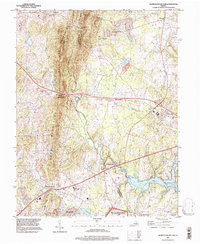 1994 Thoroughfare Gap1998 Print · USGSThe Bull Run Mountains and Thoroughfare Gap define this Prince William County landscape during the mid-nineties. Genealogists and historians can trace old community centers like Haymarket and Buckland or the extent of Vint Hill Farms Station.
 - 1994 Map of Warrenton, 1999 Print
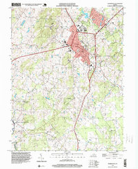 1994 Warrenton1999 Print · USGSWarrenton and its surrounding Fauquier County landscapes are captured here in the late twentieth century as the area transitioned from rural life to a growing hub. Researchers can locate local landmarks like Fauquier White Sulphur Springs, St Johns Sch, and the quiet woods of Whitney State Forest.
End of results
Showing maps 1-2 of 2
Top cities near New Baltimore
- Linton Hall historical maps
- South Riding historical maps
- Sudley historical maps
- Gainesville historical maps
- Bull Run historical maps
- Stone Ridge historical maps
See more
Top neighborhoods of New Baltimore
- Vint Hill Farms historical maps
- Jamison's Farm historical maps
- Lakewood historical maps
- Snow Hill historical maps
- Lakeway historical maps
- Brookside historical maps
See more
Frequently asked questions
- What are the different types of historical maps available for New Baltimore?
- What is the oldest map of New Baltimore?
- Where can I purchase historical maps of New Baltimore for my home or office?
- Where can I download high-res historical maps of New Baltimore?
- Are there historical topographic maps available for New Baltimore?
- Is there historical aerial imagery available for New Baltimore?
- Where are historical maps of New Baltimore sourced from?