1990s Maps of Highland County, Virginia
Explore 11 historic maps of Highland County from the 1990s. These maps offer a rare glimpse into what life looked like during the 1990s — showing old roads, neighborhoods, homes, and landmarks that have changed or disappeared over time.
Whether you're researching your family's past, planning a metal detecting trip, or studying how Highland County's landscape evolved across the 1990s, these high-resolution maps are a powerful tool for exploring the history of this region.
- Focus on a specific era: All maps on this page are from the 1990s, giving you a focused view of this time period.
- See what’s changed: Compare century-old streets, trails, and buildings to today's modern landscape using overlays and satellite layers.
- Research with precision: Use these maps for genealogy, historical research, land use analysis, or educational projects.
- View, download, or print: Maps are fully viewable online in high resolution, and can be downloaded or printed for your own records.
Start exploring Highland County's history through authentic maps from the 1990s. This is your window into the past.
Highland County, VA maps
(11)- 1995 Map of Hightown, 1998 Print
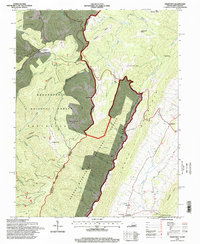 1995 Hightown1998 Print · USGSThe high ridges of the Alleghenies straddle the Virginia and West Virginia border in the mid-nineties, where two national forests meet. Trace old mountain roads and sites like Top of Allegheny Camp Allegheny, the village of Hightown, and Pisgah Ch.
 - 1995 Map of Paddy Knob, 1998 Print
 1995 Paddy Knob1998 Print · USGSThe West Virginia and Virginia borderlands come into focus during the mid-nineties as they transition between three national forests. Genealogists and local historians can trace family ties through several upland burial grounds, including Buzzard Cem, Shinaberry Cem, and Lindsay Cem.
 - 1995 Map of Sunrise, 1998 Print
 1995 Sunrise1998 Print · USGSThe Virginia and West Virginia borderlands appear in the mid-nineties as a landscape of managed forests and hydropower. Researchers can locate remote family landmarks like Sively Cem, the small settlement of Sunrise, and the industrial Powerhouse along Back Creek.
 - 1995 Map of Thornwood, 1998 Print
 1995 Thornwood1998 Print · USGSThe West Virginia and Virginia borderlands come alive in the 1990s as the high ridges of the Allegheny Mountains meet. Genealogists and hikers can trace the remote reaches of the Greenbrier River near Thornwood, locate the cemetery, and find Locust Springs.
 - 1995 Map of Snowy Mountain, 1998 Print
 1995 Snowy Mountain1998 Print · USGSThe West Virginia and Virginia borderlands near the South Branch Potomac River are captured here in the 1990s. Researchers can trace rural life through the locations of Dry Run Ch, Hardscrabble, and Elk Mtn Chapel tucked against Snowy Mountain.
 - 1995 Map of Mustoe, 1998 Print
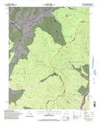
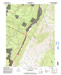
 1995 Mustoe1998 Print · USGSHighland County ridges and the Virginia-West Virginia border define this area during the mid-1990s. Genealogists and historians can locate rural landmarks such as Victory Chapel, the Green Hill Ch, and the high settlements of Mustoe and Valley Center.
 - 1999 Map of West Augusta, 2000 Print
 1999 West Augusta2000 Print · USGSThe mountain terrain of Augusta and Highland counties is captured here in the late 1990s, centered on the settlement of West Augusta. Genealogists and researchers can trace local family landmarks and burial sites like West Augusta Cem or explore the backcountry near Camp Todd and Braley Pond.
 - 1999 Map of Williamsville, 2000 Print
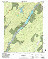
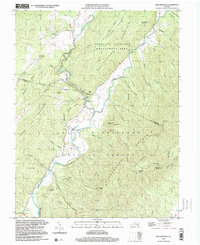 1999 Williamsville2000 Print · USGSThe river valleys of Bath and Highland Counties appear at the close of the twentieth century, centered on the convergence of the Bullpasture River and Cowpasture River. Local history researchers can trace family roots through settlements like Williamsville and Flood, or locate old landmarks including Mt Zion Ch and the Coursey Springs State Fish Hatchery.
 - 1999 Map of Palo Alto, 2000 Print
 1999 Palo Alto2000 Print · USGSThe borderlands of Augusta and Highland County meet West Virginia here in the late twentieth century, showing a landscape defined by ridges and narrow hollows. Genealogists can locate family landmarks such as Crummett Ch, Wilfong Ch, and the small settlement of Palo Alto.
 - 1999 Map of Monterey, 2001 Print
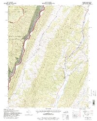
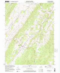 1999 Monterey2001 Print · USGSHighland County's high-mountain valleys are captured here at the close of the century, showing the rural settlement patterns of the Virginia-West Virginia border. Genealogists and local historians can trace family locations near Union Chapel, the community of New Hampden, and the landmark Trimble Knob.
 - 1999 Map of Mc Dowell, 2001 Print
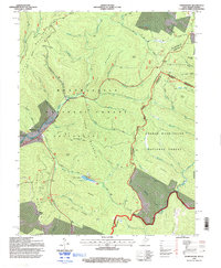
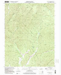
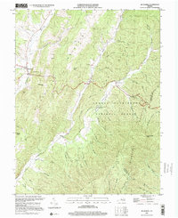 1999 Mc Dowell2001 Print · USGSHighland County at the end of the century remains a landscape of deep valleys and prominent ridges within the George Washington National Forest. Genealogists and historians can trace family locations near McDowell, Liberty, and the Hiner Ch, or locate the Columbia Union College Biological Station.
End of results
Showing maps 1-11 of 11
Top cities of Highland County
Frequently asked questions
- What are the different types of historical maps available for Highland County?
- What is the oldest map of Highland County?
- Where can I purchase historical maps of Highland County for my home or office?
- Where can I download high-res historical maps of Highland County?
- Are there historical topographic maps available for Highland County?
- Is there historical aerial imagery available for Highland County?
- Where are historical maps of Highland County sourced from?