1940s Maps of Purcellville, Virginia
Explore 3 historic maps of Purcellville from the 1940s. These maps offer a rare glimpse into what life looked like during the 1940s — showing old roads, neighborhoods, homes, and landmarks that have changed or disappeared over time.
Whether you're researching your family's past, planning a metal detecting trip, or studying how Purcellville's landscape evolved across the 1940s, these high-resolution maps are a powerful tool for exploring the history of this region.
- Focus on a specific era: All maps on this page are from the 1940s, giving you a focused view of this time period.
- See what’s changed: Compare century-old streets, trails, and buildings to today's modern landscape using overlays and satellite layers.
- Research with precision: Use these maps for genealogy, historical research, land use analysis, or educational projects.
- View, download, or print: Maps are fully viewable online in high resolution, and can be downloaded or printed for your own records.
Start exploring Purcellville's history through authentic maps from the 1940s. This is your window into the past.
Purcellville, VA maps
(3)- 1944 Map of Lincoln
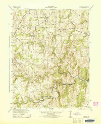 1944 Lincoln1944 Print · USGSLoudoun County’s rural Piedmont is captured in the mid-1940s during a period of agricultural and quarrying activity. Researchers can trace historic local sites such as Philomont, the Limestone Quarry, and the distinctive Suspension Foot Bridge over Goose Creek.
 - 1944 Map of Purcellville
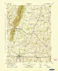 1944 Purcellville1944 Print · USGSLoudoun County is captured during the mid-forties, showing the agricultural landscape before the rapid growth of Northern Virginia. Genealogists can trace family footprints near Purcellville and Hamilton or locate rural landmarks like James Chapel and the Washington and Old Dominion line.
 - 1948 Map of Baltimore
 1948 Baltimore1948 Print · USGSMaryland and Pennsylvania crossroads are captured in the late 1940s, showing a landscape defined by historic rail lines and major military installations. Genealogists can trace family connections in Gettysburg, Westminster, and near the U.S. Naval Academy in Annapolis.2 unique versions available
End of results
Showing maps 1-3 of 3
Top cities near Purcellville
- Leesburg historical maps
- Ashburn historical maps
- South Riding historical maps
- Brambleton historical maps
- Stone Ridge historical maps
- Broadlands historical maps
See more
Top neighborhoods of Purcellville
- Valley Springs historical maps
- Hirst Farm historical maps
- Old Dominion Valley historical maps
- Locust Grove historical maps
- Hirst Farm historical maps
Frequently asked questions
- What are the different types of historical maps available for Purcellville?
- What is the oldest map of Purcellville?
- Where can I purchase historical maps of Purcellville for my home or office?
- Where can I download high-res historical maps of Purcellville?
- Are there historical topographic maps available for Purcellville?
- Is there historical aerial imagery available for Purcellville?
- Where are historical maps of Purcellville sourced from?