1970s Maps of Purcellville, Virginia
Explore 2 historic maps of Purcellville from the 1970s. These maps offer a rare glimpse into what life looked like during the 1970s — showing old roads, neighborhoods, homes, and landmarks that have changed or disappeared over time.
Whether you're researching your family's past, planning a metal detecting trip, or studying how Purcellville's landscape evolved across the 1970s, these high-resolution maps are a powerful tool for exploring the history of this region.
- Focus on a specific era: All maps on this page are from the 1970s, giving you a focused view of this time period.
- See what’s changed: Compare century-old streets, trails, and buildings to today's modern landscape using overlays and satellite layers.
- Research with precision: Use these maps for genealogy, historical research, land use analysis, or educational projects.
- View, download, or print: Maps are fully viewable online in high resolution, and can be downloaded or printed for your own records.
Start exploring Purcellville's history through authentic maps from the 1970s. This is your window into the past.
Purcellville, VA maps
(2)- 1970 Map of Purcellville, 1972 Print
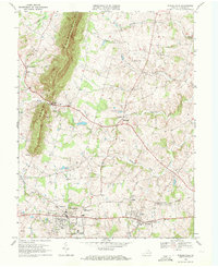 1970 Purcellville1972 Print · USGSLoudoun County's rolling Piedmont landscape is captured here in the 1970s, just as suburban growth began to reach the rural west. Genealogists and historians can trace family land around Short Hill Mountain, the Old Railroad Grade, and historic local landmarks like Ketoctin Ch.3 unique versions available
 - 1970 Map of Lincoln, 1972 Print
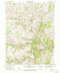 1970 Lincoln1972 Print · USGSLoudoun County’s rural character is captured here in the early seventies, featuring a landscape of established hamlets and family-named landmarks. Genealogists can trace the locations of Mt Olivet Ch, the historic Oatlands estate, and old crossings like New Guinea Bridge.2 unique versions available
End of results
Showing maps 1-2 of 2
Top cities near Purcellville
- Leesburg historical maps
- Ashburn historical maps
- South Riding historical maps
- Brambleton historical maps
- Stone Ridge historical maps
- Broadlands historical maps
See more
Top neighborhoods of Purcellville
- Valley Springs historical maps
- Hirst Farm historical maps
- Old Dominion Valley historical maps
- Locust Grove historical maps
- Hirst Farm historical maps
Frequently asked questions
- What are the different types of historical maps available for Purcellville?
- What is the oldest map of Purcellville?
- Where can I purchase historical maps of Purcellville for my home or office?
- Where can I download high-res historical maps of Purcellville?
- Are there historical topographic maps available for Purcellville?
- Is there historical aerial imagery available for Purcellville?
- Where are historical maps of Purcellville sourced from?