1950s Maps of Manassas, Virginia
Explore 8 historic maps of Manassas from the 1950s. These maps offer a rare glimpse into what life looked like during the 1950s — showing old roads, neighborhoods, homes, and landmarks that have changed or disappeared over time.
Whether you're researching your family's past, planning a metal detecting trip, or studying how Manassas's landscape evolved across the 1950s, these high-resolution maps are a powerful tool for exploring the history of this region.
- Focus on a specific era: All maps on this page are from the 1950s, giving you a focused view of this time period.
- See what’s changed: Compare century-old streets, trails, and buildings to today's modern landscape using overlays and satellite layers.
- Research with precision: Use these maps for genealogy, historical research, land use analysis, or educational projects.
- View, download, or print: Maps are fully viewable online in high resolution, and can be downloaded or printed for your own records.
Start exploring Manassas's history through authentic maps from the 1950s. This is your window into the past.
Manassas, VA maps
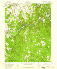
(8)- 1951 Map of Manassas, 1952 Print
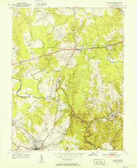 1951 Manassas1952 Print · USGSMid-century Northern Virginia is captured here during a period of steady growth along the historic Southern Railway and Lee Highway corridors. Genealogists and historians can trace family-named locations such as Johnsons Corner, Cobbs Corner, and rural landmarks like Rock Hill Ch.
 - 1951 Map of Independent Hill, 1953 Print
 1951 Independent Hill1953 Print · USGSPrince William County in the early fifties shows a landscape of small hamlets and wooded creek valleys before the major arrival of modern suburbs. You can locate rural landmarks like the Longview Park Speedway, find the Hixson Cem, or trace the winding Occoquan Creek.
 - 1953 Map of Gainesville, 1954 Print
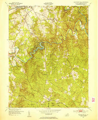
 1953 Gainesville1954 Print · USGSThe hallowed ground of Prince William County is documented here in the early fifties, just as the region began to balance its deep Civil War history with post-war growth. Researchers can trace ancestral connections through sites like Sudley Springs, the Groveton Confederate Cem, and the Vinton Hall Sch.2 unique versions available
 - 1953 Map of Nokesville, 1954 Print
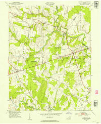
 1953 Nokesville1954 Print · USGSPrince William County in the early fifties remains a landscape of rail-side hamlets and winding creek bottoms. Researchers can trace the original footprints of Nokesville and Brentsville or locate rural landmarks like Woodlawn Ch and the grounds of Camp Upshur.
 - 1956 Map of Independent Hill, 1959 Print
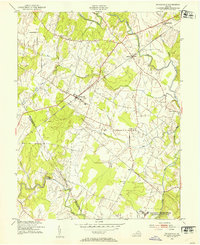
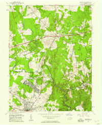
 1956 Independent Hill1959 Print · USGSPrince William County in the mid-fifties showcases a landscape of growing towns and winding waterways. Researchers can trace the development of MANASSAS near the Old Dominion Speedway or find rural landmarks like Brentsville, Woodbine Ch, and Minniville Cem.
 - 1957 Map of Manassas, 1958 Print
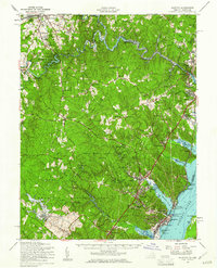
 1957 Manassas1958 Print · USGSNorthern Virginia was beginning its transition from rural farmland to suburban hub during the late fifties. You can trace the development of Manassas Park and Yorkshire or locate local landmarks like St Johns Ch and the Drive-in Theater.2 unique versions available
 - 1957 Map of Quantico, 1961 Print
 1957 Quantico1961 Print · USGSPrince William County in the late fifties shows the expansion of military and park lands along the Potomac. Trace the footprint of Quantico Marine Base and Prince William Forest Park, or locate landmarks like Lebeau Airport and Woodbine Ch.2 unique versions available
 - 1957 Map of Washington, 1966 Print
 1957 Washington1966 Print · USGSThe mid-Atlantic region during the mid-fifties and early sixties reveals a landscape of growing suburbs and vital military outposts. Researchers can trace historic river towns and shorelines from Alexandria to the Hooper Islands and St Clements Island.5 unique versions available
End of results
Showing maps 1-8 of 8
Top cities of Manassas
Frequently asked questions
- What are the different types of historical maps available for Manassas?
- What is the oldest map of Manassas?
- Where can I purchase historical maps of Manassas for my home or office?
- Where can I download high-res historical maps of Manassas?
- Are there historical topographic maps available for Manassas?
- Is there historical aerial imagery available for Manassas?
- Where are historical maps of Manassas sourced from?