1940s Maps of Nelson County, Virginia
Explore 6 historic maps of Nelson County from the 1940s. These maps offer a rare glimpse into what life looked like during the 1940s — showing old roads, neighborhoods, homes, and landmarks that have changed or disappeared over time.
Whether you're researching your family's past, planning a metal detecting trip, or studying how Nelson County's landscape evolved across the 1940s, these high-resolution maps are a powerful tool for exploring the history of this region.
- Focus on a specific era: All maps on this page are from the 1940s, giving you a focused view of this time period.
- See what’s changed: Compare century-old streets, trails, and buildings to today's modern landscape using overlays and satellite layers.
- Research with precision: Use these maps for genealogy, historical research, land use analysis, or educational projects.
- View, download, or print: Maps are fully viewable online in high resolution, and can be downloaded or printed for your own records.
Start exploring Nelson County's history through authentic maps from the 1940s. This is your window into the past.
Nelson County, VA maps
(6)- 1941 Map of Vesuvius
 1941 Vesuvius1941 Print · USGSThe Blue Ridge highlands at the start of the 1940s reveal a landscape of mountain mines and early parkway development. Genealogists and hikers can trace the Appalachian Trail past the Irish Creek Mission and forgotten sites like Mill Creek Sch.2 unique versions available
 - 1943 Map of Lovingston, 1961 Print
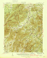
 1943 Lovingston1961 Print · USGSThe Nelson County foothills and Blue Ridge summits are captured in the early 1940s, during a transitional period for Virginia's upland communities. Genealogists and historians can trace family locations near Lovingston or find rural landmarks like Locust Grove Ch, Woods Mill, and the Stage Bridge.2 unique versions available
 - 1945 Map of Covesville
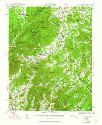
 1945 Covesville1945 Print · USGSAlbemarle County's river valleys and mountain foothills are shown here in the mid-1940s, a period defined by the convergence of rail and river commerce. Genealogists and historians can trace family locations near Alberene, Esmont, and the Mt Zion Ch, or locate old industrial sites like Johnson Mill.
 - 1946 Map of Lovingston
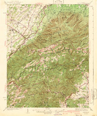
 1946 Lovingston1946 Print · USGSNelson County and the eastern slopes of the Blue Ridge are captured here in the mid-1940s, just as the regional road network was maturing. Genealogists can locate family landmarks and community hubs like Lovingston, Massies Mill, and the Dutch Creek Sch.2 unique versions available
 - 1947 Map of Roanoke, 1948 Print
 1947 Roanoke1948 Print · USGSCentral Virginia in the late 1940s reveals a region defined by its great mountain ridges and the powerful river-and-rail economy connecting Roanoke to Lynchburg. Researchers can trace the path of the Virginian RR and locate historic county seats like Charlotte Court House.2 unique versions available
 - 1949 Map of Charlottesville
 1949 Charlottesville1949 Print · USGSThe Shenandoah Valley and Blue Ridge appear in the late 1940s as a thriving corridor of rail and river commerce. Researchers can trace the mid-century footprints of Harrisonburg, Staunton, and Culpeper alongside the historic routes of the Southern Railway.2 unique versions available
End of results
Showing maps 1-6 of 6
Top cities of Nelson County
- Nellysford historical maps
- Arrington historical maps
- Lovingston historical maps
- Shipman historical maps
- Wintergreen historical maps
- Afton historical maps
Frequently asked questions
- What are the different types of historical maps available for Nelson County?
- What is the oldest map of Nelson County?
- Where can I purchase historical maps of Nelson County for my home or office?
- Where can I download high-res historical maps of Nelson County?
- Are there historical topographic maps available for Nelson County?
- Is there historical aerial imagery available for Nelson County?
- Where are historical maps of Nelson County sourced from?