1950s Maps of Northampton County, Virginia
Explore 6 historic maps of Northampton County from the 1950s. These maps offer a rare glimpse into what life looked like during the 1950s — showing old roads, neighborhoods, homes, and landmarks that have changed or disappeared over time.
Whether you're researching your family's past, planning a metal detecting trip, or studying how Northampton County's landscape evolved across the 1950s, these high-resolution maps are a powerful tool for exploring the history of this region.
- Focus on a specific era: All maps on this page are from the 1950s, giving you a focused view of this time period.
- See what’s changed: Compare century-old streets, trails, and buildings to today's modern landscape using overlays and satellite layers.
- Research with precision: Use these maps for genealogy, historical research, land use analysis, or educational projects.
- View, download, or print: Maps are fully viewable online in high resolution, and can be downloaded or printed for your own records.
Start exploring Northampton County's history through authentic maps from the 1950s. This is your window into the past.
Northampton County, VA maps
(6)- 1953 Map of Ship Shoal Inlet
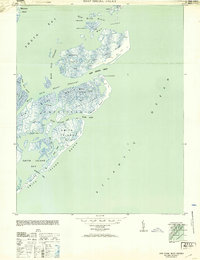 1953 Ship Shoal Inlet1953 Print · USGSThe Virginia barrier islands appear in detail on the eve of the mid-century, showing a landscape of dunes and tidal marshes. Researchers can trace early maritime outposts like the Coast Guard Lookout Station and isolated dwellings such as the Gable S Shack or Shack on piles.
 - 1955 Map of Elliotts Creek, 1956 Print
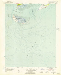
 1955 Elliotts Creek1956 Print · USGSThe Eastern Shore of Virginia reveals its maritime character in the mid-fifties as navigation lights guided ships into the Chesapeake. Genealogists and historians can locate the Arlington Tomb of Custis and trace the coastal waters of Old Plantation Cr and Elliots Creek.
 - 1955 Map of Cape Charles, 1956 Print
 1955 Cape Charles1956 Print · USGSCoastal Virginia at the southern tip of the Eastern Shore shows a landscape defined by military defense and maritime navigation in the mid-fifties. Researchers can trace the footprint of the Fisherman Island Naval Base and Cape Charles Air Force Base alongside landforms like The Isaacs and Wise Point.2 unique versions available
 - 1955 Map of Cheriton, 1956 Print
 1955 Cheriton1956 Print · USGSThe Virginia Eastern Shore is captured here in the mid-1950s, showing the agricultural 'necks' and maritime settlements between the bay and the Atlantic. Researchers can locate family landmarks like James Crossroads and Stumptown, or trace rail history at Cape Junction.
 - 1955 Map of Townsend, 1957 Print
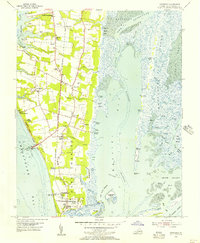 1955 Townsend1957 Print · USGSThe tip of the Virginia Eastern Shore is captured here in the mid-fifties, showing the transition from agricultural land to military and maritime sites. Genealogists and local historians can trace family-named sites like Dalbys, Arlington Wharf, and the Lower Northampton Ch while exploring the footprint of the Cape Charles Air Force Base.
 - 1959 Map of Richmond
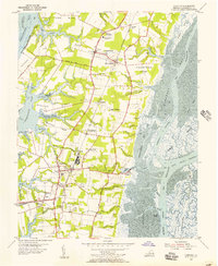
 1959 Richmond1959 Print · USGSMid-century Virginia is captured here at its most vital rail and river junctions, from the capital city to the Chesapeake Bay. Genealogists and historians can trace the development of colonial settlements like Williamsburg and military landmarks including Fort Monroe and Camp Lee.
End of results
Showing maps 1-6 of 6
Top cities of Northampton County
- Exmore historical maps
- Cape Charles historical maps
- Nassawadox historical maps
- Cheriton historical maps
- Eastville historical maps
- Willis Wharf historical maps
See more
Frequently asked questions
- What are the different types of historical maps available for Northampton County?
- What is the oldest map of Northampton County?
- Where can I purchase historical maps of Northampton County for my home or office?
- Where can I download high-res historical maps of Northampton County?
- Are there historical topographic maps available for Northampton County?
- Is there historical aerial imagery available for Northampton County?
- Where are historical maps of Northampton County sourced from?