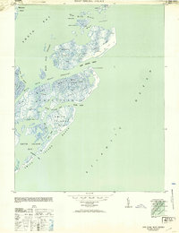
1953 Map of Ship Shoal Inlet
USGS Topo · Published 1953About this map
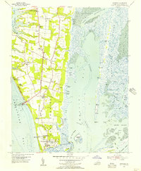
Ship Shoal Island and the intricate barrier island chain of the Eastern Shore are documented here following 1940s field surveys. The map illustrates a maritime landscape defined by shifting sands and tidal channels, such as Ship Shoal Inlet and New Inlet. Human presence in this environment is minimal, represented by scattered structures like a Shack on piles and a House on Flats located in the Red Drum Drain area. A Coast Guard Lookout Station on the dunes of Ship Shoal Island serves as a reminder of the historical importance of these inlets for coastal navigation. The interior marshes of Mink Island and Godwin Island are bisected by numerous waterways, including Mink Island Creek and Godwin Island Creek, showing the complex hydrology of Capeville before modern coastal alterations.
Find a feature on this map
34 named features on this map. Tap any name to fly to it.
Don’t see what you’re looking for? This feature index may not catch every label — zoom into the map to look around manually.
Map Details
Editions of this 1953 Ship Shoal Inlet Map
This is the sole edition of this map. No revisions or reprints were ever made.
Other maps of this area

1941 · Broadwater
USGS Topo · 1:62,500
1942 · Cheriton
USGS Topo · 1:24,000

1942 · Cobb Island
USGS Topo · 1:24,000
1942 · Great Machipongo Inlet
USGS Topo · 1:24,000

1943 · Townsend
USGS Topo · 1:24,000

1946 · Eastville
USGS Topo · 1:250,000
1955 · Cheriton
USGS Topo · 1:24,000
1955 · Townsend
USGS Topo · 1:24,000

1961 · Eastville
USGS Topo · 1:250,000

1966 · Eastville
USGS Topo · 1:250,000