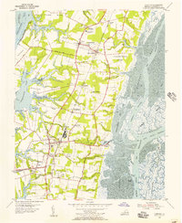
1955 Map of Cheriton
USGS Topo · Published 1956About this map
Eastville serves as the focal point of this mid-century portrait of Northampton County, anchored by the Courthouse and the Northampton High Sch. The landscape is defined by the unique "neck" geography of the Virginia Eastern Shore, where fingers of land like Savage Neck and Eyreville Neck reach toward the Chesapeake Bay. The economy of the era is clearly visible through the Pennsylvania railroad line, which connects several vital hubs including Eastville Station, Chesapeake (Cobbs Sta), and the rail junction at Cape Junction.
Find a feature on this map
67 named features on this map. Tap any name to fly to it.
Don’t see what you’re looking for? This feature index may not catch every label — zoom into the map to look around manually.
Map Details
Editions of this 1955 Cheriton Map
This is the sole edition of this map. No revisions or reprints were ever made.
Other maps of this area

1942 · Cheriton
USGS Topo · 1:24,000

1942 · Cobb Island
USGS Topo · 1:24,000

1942 · Nassawadox
USGS Topo · 1:24,000

1943 · Nassawadox
USGS Topo · 1:31,680

1943 · Elliots Creek
USGS Topo · 1:25,000

1943 · Townsend
USGS Topo · 1:24,000

1943 · Franktown
USGS Topo · 1:31,680

1943 · Richmond
USGS Topo · 1:250,000

1946 · Eastville
USGS Topo · 1:250,000

1948 · Cape Charles
USGS Topo · 1:24,000