1948 Map of Cape Charles
USGS Topo · Published 1948About this map
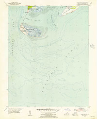
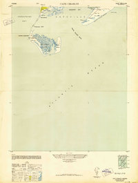
Fort John Custis dominates the northern tip of this coastal survey, reflecting the strategic military importance of the Virginia Capes during the 1940s. The landscape is defined by the shifting sands and tidal marshes of Fisherman Island and Smith Island, separated from the mainland by Magothy Bay and the narrow Fisherman Inlet. This era shows a coast heavily utilized for maritime safety and defense, featuring the Cape Charles LH, the Smith Island C G Sta, and various observation points such as Tower A and Tower 16. The presence of the National Quarantine station and a submarine Cable Area underscores the specialized functions of these outer islands. Inland, the small settlements of Cape Charles and Cape Ville anchor the peninsula, while landmarks like the Old LH (Ruins) on the beach hint at the long history of navigation in these treacherous waters.
Find a feature on this map
30 named features on this map. Tap any name to fly to it.
Don’t see what you’re looking for? This feature index may not catch every label — zoom into the map to look around manually.
Map Details
Editions of this 1948 Cape Charles Map
2 editions found
Historical Maps of Cape Charles Through Time
4 maps found