1960s Maps of Shenandoah, Virginia
Explore 4 historic maps of Shenandoah from the 1960s. These maps offer a rare glimpse into what life looked like during the 1960s — showing old roads, neighborhoods, homes, and landmarks that have changed or disappeared over time.
Whether you're researching your family's past, planning a metal detecting trip, or studying how Shenandoah's landscape evolved across the 1960s, these high-resolution maps are a powerful tool for exploring the history of this region.
- Focus on a specific era: All maps on this page are from the 1960s, giving you a focused view of this time period.
- See what’s changed: Compare century-old streets, trails, and buildings to today's modern landscape using overlays and satellite layers.
- Research with precision: Use these maps for genealogy, historical research, land use analysis, or educational projects.
- View, download, or print: Maps are fully viewable online in high resolution, and can be downloaded or printed for your own records.
Start exploring Shenandoah's history through authentic maps from the 1960s. This is your window into the past.
Shenandoah, VA maps
(4)- 1965 Map of Elkton West, 1966 Print
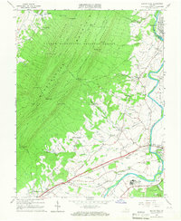 1965 Elkton West1966 Print · USGSThe Shenandoah Valley in the mid-sixties shows a landscape of steep mountain ridges and river-town commerce. Researchers can trace the heritage of McGaheysville and Elkton alongside the Chesapeake Western Railway and sites like East Point Cem.4 unique versions available
 - 1965 Map of Elkton East, 1967 Print
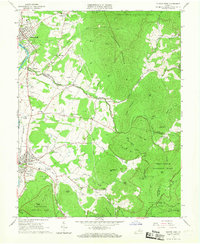 1965 Elkton East1967 Print · USGSThe Shenandoah Valley and Blue Ridge highlands meet in the 1960s, showing a landscape of river-side towns and mountain hollows. Genealogists can trace family roots at Naylor Cem or Mt Paran Ch, and follow the rails of the Norfolk and Western.3 unique versions available
 - 1967 Map of Stanley, 1969 Print
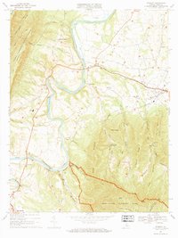 1967 Stanley1969 Print · USGSPage County is documented in the late sixties as the river-and-rail economy of the Page Valley thrived. Genealogists and local historians can trace family locations near Alma, St Lukes Ch, and the old Grove Hill Landing on the river.2 unique versions available
 - 1967 Map of Tenth Legion, 1970 Print
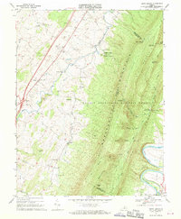 1967 Tenth Legion1970 Print · USGSThe Shenandoah Valley and the formidable slopes of Massanutten Mountain are frozen in time here during the late sixties. Genealogists and local historians can trace small communities like Arkton and Athlone or locate the Bethlehem Ch and various family cemeteries.2 unique versions available
End of results
Showing maps 1-4 of 4
Top cities near Shenandoah
- Massanetta Springs historical maps
- Luray historical maps
- Broadway historical maps
- Grottoes historical maps
- Elkton historical maps
- Massanutten historical maps
See more
Frequently asked questions
- What are the different types of historical maps available for Shenandoah?
- What is the oldest map of Shenandoah?
- Where can I purchase historical maps of Shenandoah for my home or office?
- Where can I download high-res historical maps of Shenandoah?
- Are there historical topographic maps available for Shenandoah?
- Is there historical aerial imagery available for Shenandoah?
- Where are historical maps of Shenandoah sourced from?