1990s Maps of Shenandoah, Virginia
Explore 4 historic maps of Shenandoah from the 1990s. These maps offer a rare glimpse into what life looked like during the 1990s — showing old roads, neighborhoods, homes, and landmarks that have changed or disappeared over time.
Whether you're researching your family's past, planning a metal detecting trip, or studying how Shenandoah's landscape evolved across the 1990s, these high-resolution maps are a powerful tool for exploring the history of this region.
- Focus on a specific era: All maps on this page are from the 1990s, giving you a focused view of this time period.
- See what’s changed: Compare century-old streets, trails, and buildings to today's modern landscape using overlays and satellite layers.
- Research with precision: Use these maps for genealogy, historical research, land use analysis, or educational projects.
- View, download, or print: Maps are fully viewable online in high resolution, and can be downloaded or printed for your own records.
Start exploring Shenandoah's history through authentic maps from the 1990s. This is your window into the past.
Shenandoah, VA maps
(4)- 1994 Map of Tenth Legion, 1997 Print
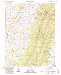 1994 Tenth Legion1997 Print · USGSShenandoah Valley life in the mid-1990s is captured here, where farmland meets the wooded slopes of the George Washington National Forest. Genealogists and historians can locate rural landmarks like Bethlehem Ch, the site of Endless Caverns, and a historic Covered Bridge.
 - 1997 Map of Elkton East, 1999 Print
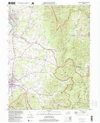 1997 Elkton East1999 Print · USGSThe Shenandoah Valley meets the Blue Ridge in the late twentieth century, showing a mix of mountain wilderness and river-town life. Trace family sites at Naylor Cem, old routes near Furnace, and springs like Bear Lithia Spring.
 - 1997 Map of Stanley, 2000 Print
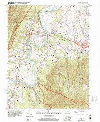 1997 Stanley2000 Print · USGSThe South Fork Shenandoah River valley in the late nineties shows a landscape defined by riverside settlements and mountain ridges. Genealogists can trace family landmarks like Longs Cem or locate rural congregations at St Pauls Ch and Leake Chapel.
 - 1999 Map of Elkton West, 2000 Print
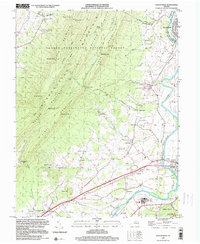 1999 Elkton West2000 Print · USGSThe Shenandoah Valley comes alive in the late 1990s as the river winds past the Massanutten ridges. Researchers can trace local heritage through landmarks like McGaheysville, the East Point Cem, and the mid-century Drive-in Theater at Solsburg.
End of results
Showing maps 1-4 of 4
Top cities near Shenandoah
- Massanetta Springs historical maps
- Luray historical maps
- Broadway historical maps
- Grottoes historical maps
- Elkton historical maps
- Massanutten historical maps
See more
Frequently asked questions
- What are the different types of historical maps available for Shenandoah?
- What is the oldest map of Shenandoah?
- Where can I purchase historical maps of Shenandoah for my home or office?
- Where can I download high-res historical maps of Shenandoah?
- Are there historical topographic maps available for Shenandoah?
- Is there historical aerial imagery available for Shenandoah?
- Where are historical maps of Shenandoah sourced from?