1950s Maps of Rockingham County, Virginia
Explore 3 historic maps of Rockingham County from the 1950s. These maps offer a rare glimpse into what life looked like during the 1950s — showing old roads, neighborhoods, homes, and landmarks that have changed or disappeared over time.
Whether you're researching your family's past, planning a metal detecting trip, or studying how Rockingham County's landscape evolved across the 1950s, these high-resolution maps are a powerful tool for exploring the history of this region.
- Focus on a specific era: All maps on this page are from the 1950s, giving you a focused view of this time period.
- See what’s changed: Compare century-old streets, trails, and buildings to today's modern landscape using overlays and satellite layers.
- Research with precision: Use these maps for genealogy, historical research, land use analysis, or educational projects.
- View, download, or print: Maps are fully viewable online in high resolution, and can be downloaded or printed for your own records.
Start exploring Rockingham County's history through authentic maps from the 1950s. This is your window into the past.
Rockingham County, VA maps
(3)- 1950 Map of Broadway
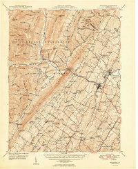 1950 Broadway1950 Print · USGSRockingham County at the mid-century mark shows a landscape defined by the Southern railroad and the North Fork River. Genealogists and historians can trace family locations near Singers Glen, Lacey Spring, and dozens of landmarks like Trissel Ch.
 - 1951 Map of Fort Seybert
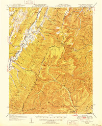 1951 Fort Seybert1951 Print · USGSThe South Fork Potomac River valley in the early 1950s reveals a landscape of isolated mountain hollows and tight-knit highland settlements. Genealogists can locate family landmarks such as Fort Seybert, New Bethlehem Ch, and the Cedar Grove Sch.2 unique versions available
 - 1956 Map of Charlottesville, 1966 Print
 1956 Charlottesville1966 Print · USGSThe Shenandoah Valley and Blue Ridge are captured in detail during the mid-1960s as the modern interstate system began to emerge. Genealogists and historians can trace rail-connected hubs like Waynesboro or follow the river paths of the Rapidan River and Rivanna River.4 unique versions available
End of results
Showing maps 1-3 of 3
Top cities of Rockingham County
- Massanetta Springs historical maps
- Bridgewater historical maps
- Broadway historical maps
- Grottoes historical maps
- Elkton historical maps
- Massanutten historical maps
See more
Frequently asked questions
- What are the different types of historical maps available for Rockingham County?
- What is the oldest map of Rockingham County?
- Where can I purchase historical maps of Rockingham County for my home or office?
- Where can I download high-res historical maps of Rockingham County?
- Are there historical topographic maps available for Rockingham County?
- Is there historical aerial imagery available for Rockingham County?
- Where are historical maps of Rockingham County sourced from?