1960s Maps of Russell County, Virginia
Explore 8 historic maps of Russell County from the 1960s. These maps offer a rare glimpse into what life looked like during the 1960s — showing old roads, neighborhoods, homes, and landmarks that have changed or disappeared over time.
Whether you're researching your family's past, planning a metal detecting trip, or studying how Russell County's landscape evolved across the 1960s, these high-resolution maps are a powerful tool for exploring the history of this region.
- Focus on a specific era: All maps on this page are from the 1960s, giving you a focused view of this time period.
- See what’s changed: Compare century-old streets, trails, and buildings to today's modern landscape using overlays and satellite layers.
- Research with precision: Use these maps for genealogy, historical research, land use analysis, or educational projects.
- View, download, or print: Maps are fully viewable online in high resolution, and can be downloaded or printed for your own records.
Start exploring Russell County's history through authentic maps from the 1960s. This is your window into the past.
Russell County, VA maps
(8)- 1960 Map of Jenkins
 1960 Jenkins1960 Print · USGSEastern Kentucky and the West Virginia borderlands are captured at a mid-century peak of the coal and rail era. Trace the industrial corridors of the Chesapeake and Ohio RR through mountain hubs like Hazard and Jenkins.
 - 1960 Map of Johnson City
 1960 Johnson City1960 Print · USGSUpper East Tennessee and the surrounding tri-state area are shown in the mid-fifties during the height of the TVA reservoir era. Trace the industrial rail lines of the Southern and Louisville and Nashville between Kingsport and Johnson City.
 - 1961 Map of Bluefield
 1961 Bluefield1961 Print · USGSThe coalfields and mountain ridges of southern West Virginia and southwest Virginia are captured in the early sixties. Genealogists can trace family ties through rail-linked towns like Princeton and Richlands or along the shores of Bluestone Reservoir.
 - 1962 Map of Winston-Salem
 1962 Winston-Salem1962 Print · USGSThe North Carolina Piedmont meets the Virginia highlands in the early sixties, showing the rail corridors and mountain gaps of the southern Appalachians. Researchers can trace the Blue Ridge Parkway or locate family sites near Winston-Salem, Mount Airy, and Hanging Rock Mountain.
 - 1963 Map of Johnson City
 1963 Johnson City1963 Print · USGSThe Tri-Cities and the surrounding Appalachian ridges are shown in detail during the early sixties, highlighting the era's vital rail and river networks. Genealogists and historians can trace the routes of the Clinchfield RR and locate settlements from Rogersville to Elizabethton.
 - 1968 Map of Richlands, 1972 Print
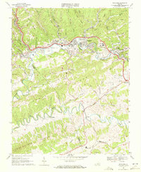 1968 Richlands1972 Print · USGSTazewell County's coal-and-rail corridor is pictured here in the late sixties, showing the industrial landscape along the Clinch River. Genealogists and historians can trace family locations at Red Ash, find Clinch Valley Mem Cemetery, or locate Southwest Virginia Community College.2 unique versions available
 - 1968 Map of Honaker, 1972 Print
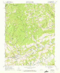 1968 Honaker1972 Print · USGSThe rugged coal country of Russell and Buchanan Counties is captured here in the late sixties, showing the reach of the NORFOLK AND WESTERN railroad. Researchers can locate family landmarks like Ball Cem, Horton Ridge Ch, and the schools at Honaker and Givens Sch.2 unique versions available
 - 1968 Map of Keen Mountain, 1972 Print
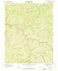 1968 Keen Mountain1972 Print · USGSIn the late sixties, the coal country of Buchanan County hummed with rail traffic and ridge-top mining. Researchers can trace family-named hollows and mining landmarks from Pilgrims Knob to Vandyke, including Bethany Ch and the Norfolk and Western line.3 unique versions available
End of results
Showing maps 1-8 of 8
Top cities of Russell County
- Lebanon historical maps
- Castlewood historical maps
- Honaker historical maps
- Dante historical maps
- Cleveland historical maps
Frequently asked questions
- What are the different types of historical maps available for Russell County?
- What is the oldest map of Russell County?
- Where can I purchase historical maps of Russell County for my home or office?
- Where can I download high-res historical maps of Russell County?
- Are there historical topographic maps available for Russell County?
- Is there historical aerial imagery available for Russell County?
- Where are historical maps of Russell County sourced from?