1950s Maps of Russell County, Virginia
Explore 19 historic maps of Russell County from the 1950s. These maps offer a rare glimpse into what life looked like during the 1950s — showing old roads, neighborhoods, homes, and landmarks that have changed or disappeared over time.
Whether you're researching your family's past, planning a metal detecting trip, or studying how Russell County's landscape evolved across the 1950s, these high-resolution maps are a powerful tool for exploring the history of this region.
- Focus on a specific era: All maps on this page are from the 1950s, giving you a focused view of this time period.
- See what’s changed: Compare century-old streets, trails, and buildings to today's modern landscape using overlays and satellite layers.
- Research with precision: Use these maps for genealogy, historical research, land use analysis, or educational projects.
- View, download, or print: Maps are fully viewable online in high resolution, and can be downloaded or printed for your own records.
Start exploring Russell County's history through authentic maps from the 1950s. This is your window into the past.
Russell County, VA maps
(19)- 1950 Map of Richlands
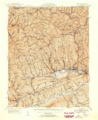 1950 Richlands1950 Print · USGSRichlands and the Clinch River valley are shown here in the late 1940s as the rail and coal industries shaped the landscape. Genealogists can trace family names through dozens of rural landmarks like Paint Lick Sch, Jewell Chapel, and the Wolfpen Ridge Cem.
 - 1953 Map of Winston-Salem, 1974 Print
 1953 Winston-Salem1974 Print · USGSThe North Carolina Piedmont and Virginia highlands meet in the mid-1950s, a landscape defined by the tobacco and textile hubs of the Blue Ridge foothills. Researchers can trace the rail-and-river geography connecting Winston-Salem to mountain towns like Mount Airy and Galax.2 unique versions available
 - 1955 Map of Johnson City
 1955 Johnson City1955 Print · USGSEast Tennessee and the bordering highlands of Virginia and Kentucky appear here during the post-war industrial boom. You can trace the complex network of mountain ridges and new TVA lakes, from Johnson City to the coalfields near Middlesboro and Lynch.
 - 1955 Map of Bluefield
 1955 Bluefield1955 Print · USGSThe Central Appalachian borderlands come alive in the mid-fifties, showing the coal and rail networks connecting Bluefield to Beckley. Researchers can trace the industrial landscape of the New River Ordnance Plant and the terrain of Burkes Garden.
 - 1955 Map of Winston-Salem
 1955 Winston-Salem1955 Print · USGSThe Central Blue Ridge and Piedmont transition are captured here in the mid-fifties, from the industrial hub of Winston-Salem to the high peaks of Southwest Virginia. Genealogists can trace family landmarks like Richmond Hill Ch, Siloam Ch, and the old rail stops along the Southern Railway.
 - 1957 Map of Toms Creek, 1960 Print
 1957 Toms Creek1960 Print · USGSIn the coalfields of Wise County during the mid-fifties, the rail lines of the Norfolk and Western were the lifeblood of the region. Genealogists can trace deep family roots through dozens of sites like Stallard Cem, McClellan Chapel, and the settlement at Coeburn.5 unique versions available
 - 1957 Map of Dungannon, 1960 Print
 1957 Dungannon1960 Print · USGSThe Clinch River valley and its iron-rail arteries come alive in this mid-century survey of Scott County. Genealogists can trace family footprints across dozens of cemeteries and country churches, from Culbertson Chapel to the Bush Mill site.3 unique versions available
 - 1957 Map of Johnson City, 1966 Print
 1957 Johnson City1966 Print · USGSUpper East Tennessee and Southwest Virginia are shown here during the mid-sixties transition of the Appalachians. Researchers can trace the industrial rail hubs of Kingsport, the sprawling waters of Cherokee Lake, and the historic Cumberland Gap.
 - 1957 Map of Bluefield, 1967 Print
 1957 Bluefield1967 Print · USGSThe heart of Central Appalachia in the mid-fifties is defined by the winding rail lines and river valleys of the coalfields. Researchers can trace the industrial footprints of towns like Welch and Princeton or locate landmarks such as the Bluestone Reservoir and Claytor Lake.2 unique versions available
 - 1957 Map of Jenkins, 1974 Print
 1957 Jenkins1974 Print · USGSThe Cumberland Plateau in the mid-twentieth century reveals a complex landscape of winding river valleys and deep-seated industry. Genealogists and historians can trace the development of Hazard, Jenkins, and Pikeville alongside extensive Numerous Oil and Gas Fields and the routes of the Chesapeake & Ohio Railway.
 - 1958 Map of Elk Garden, 1960 Print
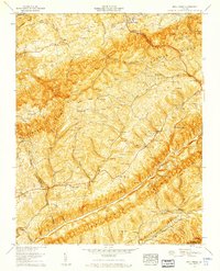
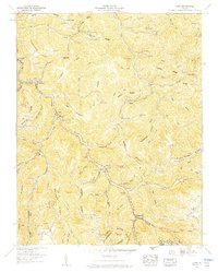
 1958 Elk Garden1960 Print · USGSRussell County's mountain landscape was defined by family homesteads and deep ridges in the late fifties. Genealogists can locate numerous family burial grounds like Ratcliff Cem and Counts Cem near the historic The Lonesome Pine Trail.6 unique versions available
 - 1958 Map of Moll Creek, 1960 Print
 1958 Moll Creek1960 Print · USGSSouthwest Virginia during the late fifties reveals a landscape of ridge-and-valley settlements connected by winding country roads and family ties. Researchers can trace ancestral locations across dozens of family-named burial grounds like Quillen Cem and rural landmarks such as Lawsons Store or Banners Corner.5 unique versions available
 - 1958 Map of Carbo, 1960 Print
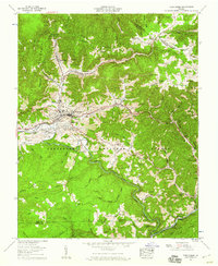
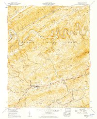
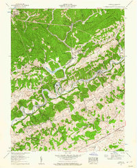 1958 Carbo1960 Print · USGSMid-century Russell County comes into focus in this 1958 survey centered on the Clinch River. Researchers and genealogists can trace the early road networks and rural structures surrounding the settlement of Carbo at the height of the post-war industrial era.4 unique versions available
 - 1958 Map of Saltville, 1960 Print
 1958 Saltville1960 Print · USGSThe industrial corridor of the Holston River meets the ridges of the Jefferson National Forest in the late fifties. Genealogists can trace dozens of family burial sites like Vencill and Settle, while historians can locate the Olin Mathieson Chemical Corp RR and R B Worthy High Sch.4 unique versions available
 - 1958 Map of Duty, 1960 Print
 1958 Duty1960 Print · USGSThe tri-county borderlands of Dickenson, Buchanan, and Russell Counties are captured here in the late fifties, showing a landscape defined by coal mining and ridge-top gaps. Genealogists can trace family names through the Sutherland, Farmer, and Gilbert cemeteries, while industrial researchers can locate the Moss No 3 Mine.3 unique versions available
 - 1958 Map of Nora, 1960 Print
 1958 Nora1960 Print · USGSCentral Dickenson County in the late fifties was a landscape of coal and rail following the winding McClure River. Genealogists can trace family landmarks and schools across the ridges, from Counts Cem and Rasnake Cem to Wakenva Sch.5 unique versions available
 - 1958 Map of Big A Mountain, 1960 Print
 1958 Big A Mountain1960 Print · USGSThe borderlands of Buchanan and Russell Counties come into focus in the late fifties, defined by isolated ridge-top schools and family hollows. Genealogists can trace deep local roots through dozens of family burial grounds like Presley Cem and Tiller Cem, alongside the Fletcher Ridge School.3 unique versions available
 - 1958 Map of St Paul, 1960 Print
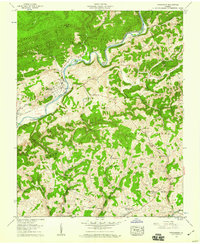
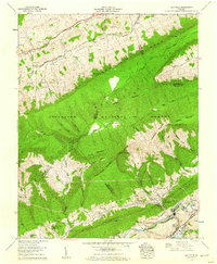
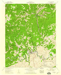 1958 St Paul1960 Print · USGSMid-century Russell and Wise Counties are seen here during a peak era of rail and coal activity along the Clinch River. Researchers can trace old family sites like the Bickley Cemetery and early industrial markers including Bickley Mill and Dante.5 unique versions available
 - 1958 Map of Lebanon, 1960 Print
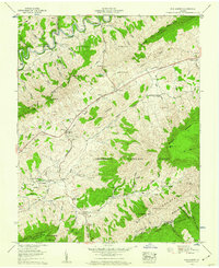
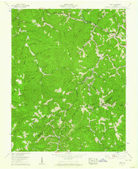
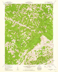
 1958 Lebanon1960 Print · USGSIn the late fifties, the Russell County landscape around Lebanon maintained its dense network of family cemeteries and mountain settlements. Genealogists can trace hundreds of local names through sites like Musick Cem and Sutherland Cem, while mapping the course of the Norfolk and Western railroad.5 unique versions available
End of results
Showing maps 1-19 of 19
Top cities of Russell County
- Lebanon historical maps
- Castlewood historical maps
- Honaker historical maps
- Dante historical maps
- Cleveland historical maps
Frequently asked questions
- What are the different types of historical maps available for Russell County?
- What is the oldest map of Russell County?
- Where can I purchase historical maps of Russell County for my home or office?
- Where can I download high-res historical maps of Russell County?
- Are there historical topographic maps available for Russell County?
- Is there historical aerial imagery available for Russell County?
- Where are historical maps of Russell County sourced from?