1930s Maps of Scott County, Virginia
Explore 34 historic maps of Scott County from the 1930s. These maps offer a rare glimpse into what life looked like during the 1930s — showing old roads, neighborhoods, homes, and landmarks that have changed or disappeared over time.
Whether you're researching your family's past, planning a metal detecting trip, or studying how Scott County's landscape evolved across the 1930s, these high-resolution maps are a powerful tool for exploring the history of this region.
- Focus on a specific era: All maps on this page are from the 1930s, giving you a focused view of this time period.
- See what’s changed: Compare century-old streets, trails, and buildings to today's modern landscape using overlays and satellite layers.
- Research with precision: Use these maps for genealogy, historical research, land use analysis, or educational projects.
- View, download, or print: Maps are fully viewable online in high resolution, and can be downloaded or printed for your own records.
Start exploring Scott County's history through authentic maps from the 1930s. This is your window into the past.
Scott County, VA maps
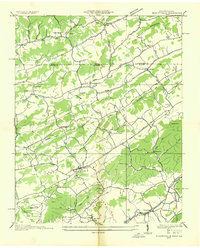
(34)- 1935 Map of Hilton
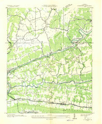
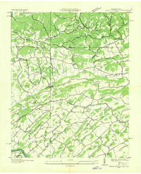
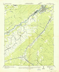
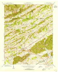
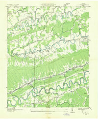 1935 Hilton1935 Print · USGSScott County in the mid-thirties reveals a landscape of high ridges and fertile river valleys at the foot of Clinch Mountain. Genealogists and historians can trace old community hubs like Mace Springs P O and Dortons Fort, along with numerous rural schools and mills.
 - 1935 Map of Wise
 1935 Wise1935 Print · USGSWise and Norton were hubs of industry in the mid-1930s, defined by the winding Guest River and an extensive network of coal mines. Researchers can trace early mining operations like Cinchfield Coal No 15 and family-named landmarks like Stallard Ch.
 - 1935 Map of Moggasin
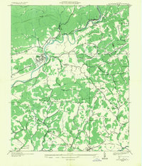
 1935 Moggasin1935 Print · USGSThe Virginia-Tennessee borderlands appear here in the mid-1930s, showing the early industrial growth of Kingsport and Gate City. Trace family roots at Wolfe Cem or locate old mills like Speers Ferry Mill along the Clinch River.
 - 1935 Map of Mendota
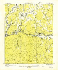
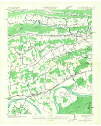
 1935 Mendota1935 Print · USGSThe North Fork Holston River winds through Southwest Virginia in the mid-1930s, showing a landscape shaped by rail and river. Genealogists can locate family landmarks like Fleenors Mill Ford, Marys Chapel, and Taylor Sch.
 - 1935 Map of Norton
 1935 Norton1935 Print · USGSIn the mid-1930s, the coal fields of Wise County were a hive of industrial activity centered around rail junctions and company towns. Researchers can trace the lineage of local families at Legion Memorial Cem and locate specific mine sites like Stonega Coal No 125 or the CCC Camp P 63.
 - 1935 Map of Looneys Gap
 1935 Looneys Gap1935 Print · USGSNortheast Tennessee and Southwest Virginia are captured here in the mid-1930s, showing a landscape of river-bottom farms and ridge-top gaps. Researchers can locate vanished landmarks like Donald Mill, Tignors Ford, and the old Snow Flake settlement.
 - 1935 Map of Blountville
 1935 Blountville1935 Print · USGSSullivan County and the Virginia borderlands are documented here in the mid-1930s, showing a rural landscape organized around the county seat and mountain ridges. Genealogists can trace family locations near Hickory Grove Sch, Linville Cave, and the Sullivan County Farm.2 unique versions available
 - 1935 Map of East Stone Gap
 1935 East Stone Gap1935 Print · USGSThe Powell Valley region of Southwest Virginia is shown here in the mid-1930s as the rail and river economy shaped the landscape. Researchers can trace the Southern RR through Elverton Station and locate community landmarks like Dortons Chapel and Cracker Neck Sch.
 - 1935 Map of Moll Creek
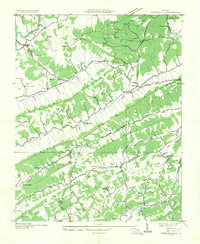
 1935 Moll Creek1935 Print · USGSSouthwest Virginia ridge-and-valley life is captured here in the mid-1930s along the border of Russell and Scott counties. Researchers can trace the rural landscape through community landmarks like Lawsons Store, Point Truth, and Moll Creek Ch.
 - 1935 Map of Kingsport
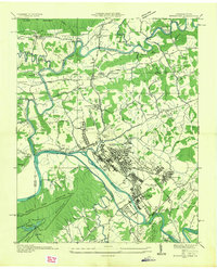 1935 Kingsport1935 Print · USGSKingsport and the surrounding Holston River valley are captured in the mid-thirties as industrial growth began to reshape the landscape. Researchers can locate community anchors like CCC Camp 2427, Sensabaugh Tunnel, and the sprawling Eastman complex.
 - 1935 Map of Clinchport
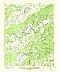
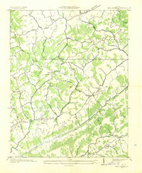
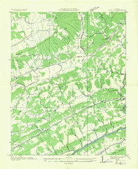
 1935 Clinchport1935 Print · USGSScott County in the mid-1930s is defined by the steep ridges and deep valleys of the Clinch River system. Researchers can locate family landmarks such as Riggs Chapel, Fugate Mill, and the rail operations at Danlboone Yard.
 - 1935 Map of Duffield
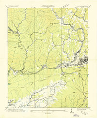
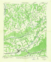
 1935 Duffield1935 Print · USGSScott County, Virginia, is captured here in the mid-1930s as a landscape of isolated mountain settlements and riverside mills. Researchers can trace the heritage of rural communities through landmarks like Sunbright Hortons Summit P O, Lawson Mill, and Pattonsville Sch.
 - 1935 Map of Gate City
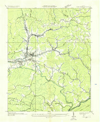
 1935 Gate City1935 Print · USGSScott County, Virginia, is captured in the mid-1930s as a landscape of river-valley settlements and ridge-top churches. Genealogists and local historians can trace the foundations of Gate City and find rural landmarks like Starnes Slant PO, Carrico Mill, and Moccasin Gap.
 - 1935 Map of Fort Blackmore
 1935 Fort Blackmore1935 Print · USGSIn the mid-1930s, this area of Scott County was a landscape of steep ridges and river-dependent transport along the Clinch River. Researchers can trace the early rail-and-river economy through sites like Greer Siding, Mann Ferry, and the settlement at Fort Blackmore.
 - 1935 Map of Indian Springs
 1935 Indian Springs1935 Print · USGSSullivan County and the Virginia borderlands are captured here in the mid-1930s as modern power and aviation networks began to reach these rural communities. Genealogists can locate family landmarks like Pyles Cem, Huddle Mill, and numerous neighborhood schools including Shadylawn Sch.
 - 1935 Map of Mages
 1935 Mages1935 Print · USGSThe Tennessee-Virginia borderlands appear here in the mid-1930s, showing a landscape of ridge-and-valley settlements and rural crossroads. Researchers can locate numerous family-centered sites including Pyles Cem, St Joseph Ch, and Mill Point.
 - 1935 Map of Plum Grove
 1935 Plum Grove1935 Print · USGSCrossing the Tennessee and Virginia border in the mid-1930s, this survey documents the ridge-and-valley settlements of Hawkins and Scott counties. Genealogists can locate family-named sites like Fansler and Wildcat or trace roots at Amos Chapel and Oak Lawn School.
 - 1935 Map of Church Hill
 1935 Church Hill1935 Print · USGSThe Hawkins County countryside and the Holston River valley are captured here in the mid-1930s during a period of significant rural development. Genealogists and local historians can trace family locations near Old Union Ch, find the vanished site of Bradshaw Mill, and locate long-standing river crossings like Solitude Ford.
 - 1935 Map of Toms Creek
 1935 Toms Creek1935 Print · USGSWise County's coal and rail economy is on full display in the mid-1930s, centered on the bustling junctions of the Guest River valley. Genealogists and historians can locate family sites like Kilgore Cem, coal operations at Clinchfield No. 21, and the strategic Beverly Tunnel.
 - 1935 Map of Olinger
 1935 Olinger1935 Print · USGSBig Stone Gap and the surrounding coal ridges of Southwest Virginia are captured here in the mid-1930s. Genealogists and local historians can trace family locations near Seminary Sch, Olinger, and church sites like Robinette Chapel or Union Ch.
 - 1935 Map of Dungannon
 1935 Dungannon1935 Print · USGSSouthwest Virginia's river valleys and ridgelines are documented here during the mid-1930s, showing the early infrastructure of the Clinch River corridor. Genealogists can trace family footprints through numerous rural schools and churches like New Bethel Sch, Wells Chapel, and the settlement at Nickelsville.
 - 1935 Map of Stickleyville
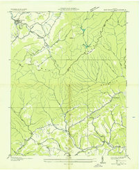
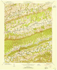
 1935 Stickleyville1935 Print · USGSSouthwest Virginia's mountain ridges and valley settlements are frozen in time just before the mid-century, showing a landscape defined by Wallen Ridge and the Powell River. Genealogists and local historians can trace family roots through landmarks like Carters Institute, Osborne Mill, and the Robinette Cem.
 - 1938 Map of Hilton, 1954 Print
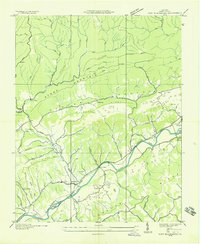
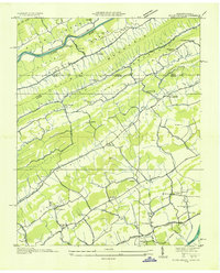
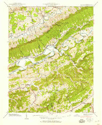
 1938 Hilton1954 Print · USGSScott County settlement patterns follow the winding waters of Copper Creek and the North Fork Holston River in the late thirties. Genealogists can trace early landmarks like Dorton Fort, McConnell Mill, and Francisco Cem.4 unique versions available
 - 1938 Map of Blountville, 1954 Print
 1938 Blountville1954 Print · USGSSullivan County and the Virginia borderlands are captured here in the late thirties as a network of ridge-top schools and valley churches. Genealogists can trace family landmarks like the Latture Cem, Fraley Institute, and the local County Farm.
 - 1938 Map of Mendota, 1959 Print
 1938 Mendota1959 Print · USGSSouthwest Virginia's river valleys and mountain gaps are captured here just before the late thirties, showing a landscape shaped by the Southern Railway. Genealogists and local historians can locate Barker Mill, the Valley Institute, and several family cemeteries like Fleenor Cem.4 unique versions available
Showing maps 1-25 of 34
Top cities of Scott County
- Gate City historical maps
- Weber City historical maps
- Nickelsville historical maps
- Hiltons historical maps
- Dungannon historical maps
- Duffield historical maps
See more
Frequently asked questions
- What are the different types of historical maps available for Scott County?
- What is the oldest map of Scott County?
- Where can I purchase historical maps of Scott County for my home or office?
- Where can I download high-res historical maps of Scott County?
- Are there historical topographic maps available for Scott County?
- Is there historical aerial imagery available for Scott County?
- Where are historical maps of Scott County sourced from?