1970s Maps of Scott County, Virginia
Explore 4 historic maps of Scott County from the 1970s. These maps offer a rare glimpse into what life looked like during the 1970s — showing old roads, neighborhoods, homes, and landmarks that have changed or disappeared over time.
Whether you're researching your family's past, planning a metal detecting trip, or studying how Scott County's landscape evolved across the 1970s, these high-resolution maps are a powerful tool for exploring the history of this region.
- Focus on a specific era: All maps on this page are from the 1970s, giving you a focused view of this time period.
- See what’s changed: Compare century-old streets, trails, and buildings to today's modern landscape using overlays and satellite layers.
- Research with precision: Use these maps for genealogy, historical research, land use analysis, or educational projects.
- View, download, or print: Maps are fully viewable online in high resolution, and can be downloaded or printed for your own records.
Start exploring Scott County's history through authentic maps from the 1970s. This is your window into the past.
Scott County, VA maps
(4)- 1976 Map of Looneys Gap, 1981 Print
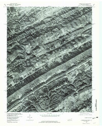 1976 Looneys Gap1981 Print · USGSHawkins County, Tennessee and neighboring Virginia appear in sharp photographic detail in the mid-seventies. Researchers can trace the layout of rural communities like Dona and Snow Flake or locate family sites near Looneys Gap.
 - 1976 Map of Stickleyville, 1981 Print
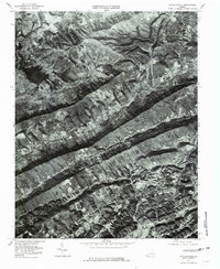 1976 Stickleyville1981 Print · USGSLee County's mountain landscape is captured here in the mid-seventies, showing the valley settlements and steep ridges of southwestern Virginia. Genealogists and historians can trace the rural layouts of Stickleyville, Woodway, and Fairview between the peaks of Wallen Ridge.
 - 1976 Map of Big Stone Gap, 1981 Print
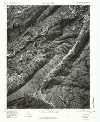 1976 Big Stone Gap1981 Print · USGSBig Stone Gap and the surrounding coal country are shown in mid-seventies detail through this high-altitude orthophoto. Researchers can trace the development of mountain settlements like Exeter, Seminary, and Jasper along the banks of the Powell River.
 - 1976 Map of Duffield, 1981 Print
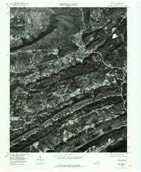 1976 Duffield1981 Print · USGSScott County, Virginia, is captured in the mid-seventies just as the valley corridors were seeing modern highway and rail developments. Genealogists and local historians can trace family-named landmarks and old settlements like Pattonsville, Fraleytown, and Sloantown.
End of results
Showing maps 1-4 of 4
Top cities of Scott County
- Gate City historical maps
- Weber City historical maps
- Nickelsville historical maps
- Hiltons historical maps
- Dungannon historical maps
- Duffield historical maps
See more
Frequently asked questions
- What are the different types of historical maps available for Scott County?
- What is the oldest map of Scott County?
- Where can I purchase historical maps of Scott County for my home or office?
- Where can I download high-res historical maps of Scott County?
- Are there historical topographic maps available for Scott County?
- Is there historical aerial imagery available for Scott County?
- Where are historical maps of Scott County sourced from?