1990s Maps of Strasburg, Virginia
Explore 4 historic maps of Strasburg from the 1990s. These maps offer a rare glimpse into what life looked like during the 1990s — showing old roads, neighborhoods, homes, and landmarks that have changed or disappeared over time.
Whether you're researching your family's past, planning a metal detecting trip, or studying how Strasburg's landscape evolved across the 1990s, these high-resolution maps are a powerful tool for exploring the history of this region.
- Focus on a specific era: All maps on this page are from the 1990s, giving you a focused view of this time period.
- See what’s changed: Compare century-old streets, trails, and buildings to today's modern landscape using overlays and satellite layers.
- Research with precision: Use these maps for genealogy, historical research, land use analysis, or educational projects.
- View, download, or print: Maps are fully viewable online in high resolution, and can be downloaded or printed for your own records.
Start exploring Strasburg's history through authentic maps from the 1990s. This is your window into the past.
Strasburg, VA maps
(4)- 1994 Map of Strasburg, 1997 Print
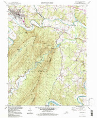 1994 Strasburg1997 Print · USGSThe Shenandoah Valley remains a vital rail and river corridor in the 1990s as the mountains frame a landscape of legacy and leisure. Trace the intersection of the Southern railroad at Strasburg, find old rural landmarks like Bennett Chapel, or explore the complex terrain of the Elizabeth Furnace Recreational Area.
 - 1994 Map of Toms Brook, 1997 Print
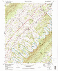 1994 Toms Brook1997 Print · USGSShenandoah Valley life in the mid-to-late twentieth century is captured here as the river meanders through the famous Seven Bends. Researchers can trace old family sites and rural infrastructure, from the County Home and Keller Cem to the Burnshire Bridge and St Johns Ch.
 - 1999 Map of Middletown, 2000 Print
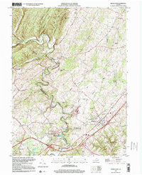 1999 Middletown2000 Print · USGSMiddletown and the surrounding Shenandoah Valley ridges are shown here just before the turn of the millennium, centered on the storied Cedar Creek Battlefield. Researchers can locate historic landmarks like Nieswanders Fort (Ruins), Monroe College, and Crystal Caverns.
 - 1999 Map of Mountain Falls, 2001 Print
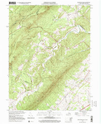 1999 Mountain Falls2001 Print · USGSThe Virginia-West Virginia borderlands at the close of the twentieth century show a landscape of deep hollows and persistent rural settlements. Genealogists can locate family landmarks like Gravel Springs Cem, Star Tannery, and St Stephens Ch along the base of North Mountain.
End of results
Showing maps 1-4 of 4
Top cities near Strasburg
- Winchester historical maps
- Front Royal historical maps
- Woodstock historical maps
- Stephens City historical maps
- Shawneeland historical maps
- Middletown historical maps
See more
Frequently asked questions
- What are the different types of historical maps available for Strasburg?
- What is the oldest map of Strasburg?
- Where can I purchase historical maps of Strasburg for my home or office?
- Where can I download high-res historical maps of Strasburg?
- Are there historical topographic maps available for Strasburg?
- Is there historical aerial imagery available for Strasburg?
- Where are historical maps of Strasburg sourced from?