1960s Maps of Strasburg, Virginia
Explore 6 historic maps of Strasburg from the 1960s. These maps offer a rare glimpse into what life looked like during the 1960s — showing old roads, neighborhoods, homes, and landmarks that have changed or disappeared over time.
Whether you're researching your family's past, planning a metal detecting trip, or studying how Strasburg's landscape evolved across the 1960s, these high-resolution maps are a powerful tool for exploring the history of this region.
- Focus on a specific era: All maps on this page are from the 1960s, giving you a focused view of this time period.
- See what’s changed: Compare century-old streets, trails, and buildings to today's modern landscape using overlays and satellite layers.
- Research with precision: Use these maps for genealogy, historical research, land use analysis, or educational projects.
- View, download, or print: Maps are fully viewable online in high resolution, and can be downloaded or printed for your own records.
Start exploring Strasburg's history through authentic maps from the 1960s. This is your window into the past.
Strasburg, VA maps
(6)- 1961 Map of Cumberland
 1961 Cumberland1961 Print · USGSThe tri-state highlands of Maryland, West Virginia, and Pennsylvania are shown in the mid-twentieth century as a complex landscape of ridges and river valleys. Researchers can trace the winding Potomac River and find old rail-and-river towns like Cumberland, Keyser, and Morgantown.
 - 1962 Map of Cumberland
 1962 Cumberland1962 Print · USGSThe central Appalachians meet at the height of the mid-century industrial era, showing the rugged topography between Morgantown and Winchester. Genealogists can trace family lands near Fort Necessity or along the vital Baltimore & Ohio RR corridors.
 - 1965 Map of Mountain Falls, 1968 Print
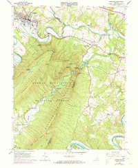
 1965 Mountain Falls1968 Print · USGSThe Virginia and West Virginia borderlands in the mid-1960s reveal a landscape of mountain ridges and secluded valley settlements. Genealogists and historians can trace family locations through landmarks like Star Tannery, Gravel Springs Cem, and the Mineral Mine.3 unique versions available
 - 1966 Map of Toms Brook, 1968 Print
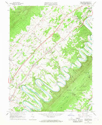 1966 Toms Brook1968 Print · USGSShenandoah Valley life in the mid-sixties is captured here as the river loops around Seven Bends while the new interstate begins to change local transit. Genealogists can locate family landmarks like the Keller Cem, Emmanuel Ch, and the site of the County Home.4 unique versions available
 - 1966 Map of Middletown, 1968 Print
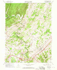 1966 Middletown1968 Print · USGSMiddletown and the surrounding Shenandoah Valley are captured in the mid-1960s, showing a landscape defined by Civil War history and rural industry. Researchers can trace ancestral sites like Quaker Cem, the ruins of Nieswander's Fort, and landmarks such as Monroe College.3 unique versions available
 - 1966 Map of Strasburg, 1973 Print
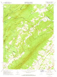
 1966 Strasburg1973 Print · USGSThe Shenandoah Valley during the mid-1960s shows a mix of mountain wilderness and riverside rail hubs. Trace local history through the Elizabeth Furnace Recreational Area ruins, the Otterburn Sch, and established crossroads like Waterlick and Buckton.2 unique versions available
End of results
Showing maps 1-6 of 6
Top cities near Strasburg
- Winchester historical maps
- Front Royal historical maps
- Woodstock historical maps
- Stephens City historical maps
- Shawneeland historical maps
- Middletown historical maps
See more
Frequently asked questions
- What are the different types of historical maps available for Strasburg?
- What is the oldest map of Strasburg?
- Where can I purchase historical maps of Strasburg for my home or office?
- Where can I download high-res historical maps of Strasburg?
- Are there historical topographic maps available for Strasburg?
- Is there historical aerial imagery available for Strasburg?
- Where are historical maps of Strasburg sourced from?