Old Maps of Strasburg, Virginia for Genealogy
Trace your family roots with 32 historic maps of Strasburg. These high-res maps reveal old neighborhoods, homesites, landmarks, and streets — helping you uncover where your ancestors lived and how the area evolved over time.
- Explore historic neighborhoods: Identify where your relatives may have lived in the 1800s or 1900s.
- Compare maps over time: Trace the changes in streets, buildings, and landmarks for multi-generational research.
- Perfect for genealogy & ancestry research: Used by family historians and researchers to map out lineage and migration.
These maps are an incredible resource for exploring your personal connection to Strasburg's past.
Strasburg, VA maps
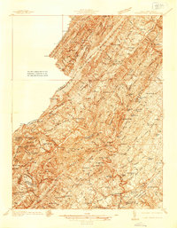
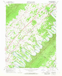
(32)- 1893 Map of Luray, 1898 Print
 1893 Luray1898 Print · USGSThe Shenandoah Valley in the 1890s was a land of steep mountain ridges and vital new railways. Genealogists and historians can trace old homesteads and depots along the Shenandoah Valley Railroad or find remote hamlets like Seven Fountains and Browntown.
 - 1894 Map of Winchester, 1899 Print
 1894 Winchester1899 Print · USGSThe Virginia and West Virginia borderlands appear here in the late nineteenth century, showing a landscape defined by mountain ridges and bustling rail junctions. Researchers can trace early rural life through family-named sites like Unger Store and Fawcetts Gap or the resort history of Capon Springs.6 unique versions available
 - 1905 Map of Luray, 1910 Print
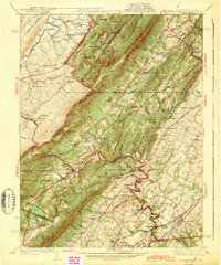
 1905 Luray1910 Print · USGSThe Blue Ridge and Shenandoah Valley are frozen in time just after the turn of the century, showing the critical rail networks and mountain gaps of the period. Genealogists can trace family names and settlements like Luray, Front Royal, and Strasburg along the Shenandoah Valley Railroad.4 unique versions available
 - 1923 Map of Middletown
 1923 Middletown1923 Print · USGSThe West Virginia and Virginia borderlands were a patchwork of mountain farms and river crossings in the early 1920s. Genealogists can trace family names through landmarks like Hooks Mills, Capon Springs, and the Christian Church.
 - 1937 Map of Middletown
 1937 Middletown1937 Print · USGSFrederick and Shenandoah Counties are surveyed here in the late 1930s, documenting the valley's ridge-and-hollow terrain and Civil War history. Genealogists can locate family landmarks like Nieswanders Fort, Quaker Hill Cem, and the industry at Star Tannery.2 unique versions available
 - 1943 Map of Middletown
 1943 Middletown1943 Print · USGSThe Virginia and West Virginia borderlands are revealed in this wartime-era survey of Frederick County and the surrounding ridges. Genealogists and historians can trace family locations near Star Tannery, the Cedar Creek Battlefield, or old schoolhouses like Mountain View Sch.2 unique versions available
 - 1947 Map of Strasburg, 1955 Print
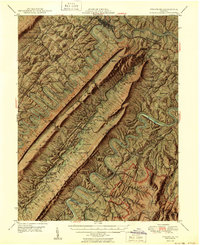
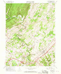
 1947 Strasburg1955 Print · USGSThe Shenandoah Valley during the late 1940s reveals a landscape defined by the winding North and South Forks of the river and the steep ridges of Massanutten. Genealogists can locate rural landmarks like Saint Davids Church, Bentonville, and the Mt Hebron Ch Cem.7 unique versions available
 - 1948 Map of Cumberland
 1948 Cumberland1948 Print · USGSMid-century Appalachia and the Shenandoah Valley are shown in detail, documenting the industrial and transportation hubs of the tri-state area. Genealogists can trace family roots through settlements like Double Tollgate and Bunker Hill or along the Baltimore & Ohio RR.3 unique versions available
 - 1949 Map of Charlottesville
 1949 Charlottesville1949 Print · USGSThe Shenandoah Valley and Blue Ridge appear in the late 1940s as a thriving corridor of rail and river commerce. Researchers can trace the mid-century footprints of Harrisonburg, Staunton, and Culpeper alongside the historic routes of the Southern Railway.2 unique versions available
 - 1950 Map of Strasburg
 1950 Strasburg1950 Print · USGSThe northern Shenandoah Valley is shown just after the war, defined by the winding forks of the river and the massive ridges of Massanutten Mountain. Genealogists and historians can trace family sites at Mt Hebron Cemetery, Goode Mill, and the mountain-bound community of Seven Fountains.2 unique versions available
 - 1952 Map of Cumberland
 1952 Cumberland1952 Print · USGSThe Potomac Highlands and the Shenandoah Valley are revealed in this early 1950s survey of the Appalachian interior. Researchers can trace the river-and-rail corridors connecting Cumberland, Winchester, and the recreational waters of Deep Creek Lake.
 - 1956 Map of Cumberland, 1966 Print
 1956 Cumberland1966 Print · USGSThe tri-state Highlands in the mid-1950s show a landscape shaped by coal, timber, and the massive presence of the Baltimore & Ohio RR. Researchers can trace the industrial corridor from Cumberland through the Allegheny Mountains to mountain retreats like Deep Creek Lake.6 unique versions available
 - 1956 Map of Charlottesville, 1966 Print
 1956 Charlottesville1966 Print · USGSThe Shenandoah Valley and Blue Ridge are captured in detail during the mid-1960s as the modern interstate system began to emerge. Genealogists and historians can trace rail-connected hubs like Waynesboro or follow the river paths of the Rapidan River and Rivanna River.4 unique versions available
 - 1957 Map of Cumberland
 1957 Cumberland1957 Print · USGSThe Potomac River valley and the ridges of the Allegheny Front define this mid-century landscape at the intersection of Maryland, West Virginia, and Pennsylvania. Trace the steam-era rail lines of the Baltimore and Ohio RR or locate rural landmarks like St Stephens Church and Stony River Dam.
 - 1961 Map of Cumberland
 1961 Cumberland1961 Print · USGSThe tri-state highlands of Maryland, West Virginia, and Pennsylvania are shown in the mid-twentieth century as a complex landscape of ridges and river valleys. Researchers can trace the winding Potomac River and find old rail-and-river towns like Cumberland, Keyser, and Morgantown.
 - 1962 Map of Cumberland
 1962 Cumberland1962 Print · USGSThe central Appalachians meet at the height of the mid-century industrial era, showing the rugged topography between Morgantown and Winchester. Genealogists can trace family lands near Fort Necessity or along the vital Baltimore & Ohio RR corridors.
 - 1965 Map of Mountain Falls, 1968 Print
 1965 Mountain Falls1968 Print · USGSThe Virginia and West Virginia borderlands in the mid-1960s reveal a landscape of mountain ridges and secluded valley settlements. Genealogists and historians can trace family locations through landmarks like Star Tannery, Gravel Springs Cem, and the Mineral Mine.3 unique versions available
 - 1966 Map of Toms Brook, 1968 Print
 1966 Toms Brook1968 Print · USGSShenandoah Valley life in the mid-sixties is captured here as the river loops around Seven Bends while the new interstate begins to change local transit. Genealogists can locate family landmarks like the Keller Cem, Emmanuel Ch, and the site of the County Home.4 unique versions available
 - 1966 Map of Middletown, 1968 Print
 1966 Middletown1968 Print · USGSMiddletown and the surrounding Shenandoah Valley are captured in the mid-1960s, showing a landscape defined by Civil War history and rural industry. Researchers can trace ancestral sites like Quaker Cem, the ruins of Nieswander's Fort, and landmarks such as Monroe College.3 unique versions available
 - 1966 Map of Strasburg, 1973 Print
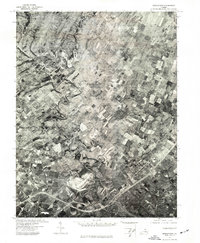
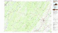
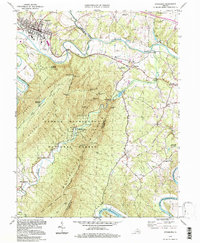
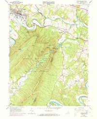 1966 Strasburg1973 Print · USGSThe Shenandoah Valley during the mid-1960s shows a mix of mountain wilderness and riverside rail hubs. Trace local history through the Elizabeth Furnace Recreational Area ruins, the Otterburn Sch, and established crossroads like Waterlick and Buckton.2 unique versions available
 - 1972 Map of Strasburg, 1977 Print
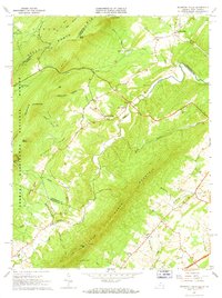
 1972 Strasburg1977 Print · USGSStrasburg and the Shenandoah Valley are captured in high-altitude detail during the early 1970s. Local researchers can trace the winding North Fork Shenandoah River as it passes Strasburg and the rural community of Waterlick.
 - 1972 Map of Middletown, 1977 Print
 1972 Middletown1977 Print · USGSThe Shenandoah Valley comes into sharp focus during the early seventies, showing the intersection of local agriculture and community growth. Trace the winding path of Cedar Creek and the established layouts of Middletown and Lebanon Church.
 - 1983 Map of Winchester, 1985 Print
 1983 Winchester1985 Print · USGSThe northern Shenandoah Valley and the rugged West Virginia borderlands are captured here in the early eighties. Researchers can trace the rail networks of the B & O RR and find local landmarks like Potomac State College, Three Churches, and the Old Iron Furnace.3 unique versions available
 - 1986 Map of Front Royal
 1986 Front Royal1986 Print · USGSThe northern Shenandoah Valley and the Blue Ridge crest are captured here in the mid-eighties as modern highways began to bypass historic valley towns. Researchers can trace ancestral connections near Peola Mills, navigate the gaps like Manassas Gap, or study the river bends around Luray.3 unique versions available
 - 1994 Map of Strasburg, 1997 Print
 1994 Strasburg1997 Print · USGSThe Shenandoah Valley remains a vital rail and river corridor in the 1990s as the mountains frame a landscape of legacy and leisure. Trace the intersection of the Southern railroad at Strasburg, find old rural landmarks like Bennett Chapel, or explore the complex terrain of the Elizabeth Furnace Recreational Area.
Showing maps 1-25 of 32
Top cities near Strasburg
- Winchester historical maps
- Front Royal historical maps
- Woodstock historical maps
- Stephens City historical maps
- Shawneeland historical maps
- Middletown historical maps
See more
Frequently asked questions
- What are the different types of historical maps available for Strasburg?
- What is the oldest map of Strasburg?
- Where can I purchase historical maps of Strasburg for my home or office?
- Where can I download high-res historical maps of Strasburg?
- Are there historical topographic maps available for Strasburg?
- Is there historical aerial imagery available for Strasburg?
- Where are historical maps of Strasburg sourced from?