1940s Maps of Woodstock, Virginia
Explore 3 historic maps of Woodstock from the 1940s. These maps offer a rare glimpse into what life looked like during the 1940s — showing old roads, neighborhoods, homes, and landmarks that have changed or disappeared over time.
Whether you're researching your family's past, planning a metal detecting trip, or studying how Woodstock's landscape evolved across the 1940s, these high-resolution maps are a powerful tool for exploring the history of this region.
- Focus on a specific era: All maps on this page are from the 1940s, giving you a focused view of this time period.
- See what’s changed: Compare century-old streets, trails, and buildings to today's modern landscape using overlays and satellite layers.
- Research with precision: Use these maps for genealogy, historical research, land use analysis, or educational projects.
- View, download, or print: Maps are fully viewable online in high resolution, and can be downloaded or printed for your own records.
Start exploring Woodstock's history through authentic maps from the 1940s. This is your window into the past.
Woodstock, VA maps
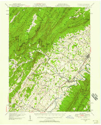
(3)- 1947 Map of Strasburg, 1955 Print
 1947 Strasburg1955 Print · USGSThe Shenandoah Valley during the late 1940s reveals a landscape defined by the winding North and South Forks of the river and the steep ridges of Massanutten. Genealogists can locate rural landmarks like Saint Davids Church, Bentonville, and the Mt Hebron Ch Cem.7 unique versions available
 - 1947 Map of Edinburg, 1958 Print
 1947 Edinburg1958 Print · USGSThe Shenandoah Valley is mapped here just after the war, showing the historic transportation spine between Woodstock and Mt Jackson. Researchers can trace rural life through landmarks like Columbia Furnace, Lantz Mills, and Union Forge Ch.2 unique versions available
 - 1949 Map of Charlottesville
 1949 Charlottesville1949 Print · USGSThe Shenandoah Valley and Blue Ridge appear in the late 1940s as a thriving corridor of rail and river commerce. Researchers can trace the mid-century footprints of Harrisonburg, Staunton, and Culpeper alongside the historic routes of the Southern Railway.2 unique versions available
End of results
Showing maps 1-3 of 3
Top cities near Woodstock
- Strasburg historical maps
- Luray historical maps
- New Market historical maps
- Mount Jackson historical maps
- Edinburg historical maps
- Maurertown historical maps
See more
Frequently asked questions
- What are the different types of historical maps available for Woodstock?
- What is the oldest map of Woodstock?
- Where can I purchase historical maps of Woodstock for my home or office?
- Where can I download high-res historical maps of Woodstock?
- Are there historical topographic maps available for Woodstock?
- Is there historical aerial imagery available for Woodstock?
- Where are historical maps of Woodstock sourced from?