1990s Maps of Woodstock, Virginia
Explore 4 historic maps of Woodstock from the 1990s. These maps offer a rare glimpse into what life looked like during the 1990s — showing old roads, neighborhoods, homes, and landmarks that have changed or disappeared over time.
Whether you're researching your family's past, planning a metal detecting trip, or studying how Woodstock's landscape evolved across the 1990s, these high-resolution maps are a powerful tool for exploring the history of this region.
- Focus on a specific era: All maps on this page are from the 1990s, giving you a focused view of this time period.
- See what’s changed: Compare century-old streets, trails, and buildings to today's modern landscape using overlays and satellite layers.
- Research with precision: Use these maps for genealogy, historical research, land use analysis, or educational projects.
- View, download, or print: Maps are fully viewable online in high resolution, and can be downloaded or printed for your own records.
Start exploring Woodstock's history through authentic maps from the 1990s. This is your window into the past.
Woodstock, VA maps
(4)- 1994 Map of Edinburg, 1997 Print
 1994 Edinburg1997 Print · USGSThe Shenandoah Valley in the late twentieth century remains a landscape shaped by its river and ridges, from the streets of Edinburg to the heights of Powell Mountain. Genealogists and local historians can locate rural landmarks like Cedarwood Cem, Wesley Chapel, and the historic Massanutten Military Academy.
 - 1994 Map of Toms Brook, 1997 Print
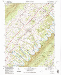 1994 Toms Brook1997 Print · USGSShenandoah Valley life in the mid-to-late twentieth century is captured here as the river meanders through the famous Seven Bends. Researchers can trace old family sites and rural infrastructure, from the County Home and Keller Cem to the Burnshire Bridge and St Johns Ch.
 - 1994 Map of Rileyville, 1997 Print
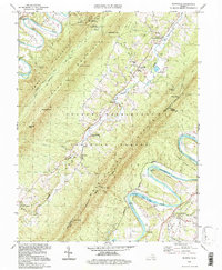 1994 Rileyville1997 Print · USGSShenandoah and Page Counties are shown in the mid-1990s, where the Shenandoah River loops around the ridges of Massanutten Mountain. Researchers can locate ancestral sites like Rileyville, Goods Mill, and rural congregations at Saint Davids Church or White Chapel.
 - 1994 Map of Woodstock, 1997 Print
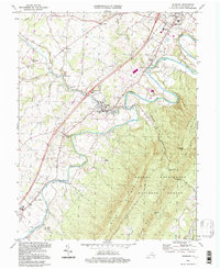
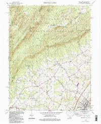 1994 Woodstock1997 Print · USGSThe Shenandoah Valley and the rugged ridges of the national forest are captured here in the mid-1990s. Genealogists and historians can trace families across the settlements of St Luke and Alonzaville, or locate landmarks like Van Buren Furnace and Massanutten Military Academy.
End of results
Showing maps 1-4 of 4
Top cities near Woodstock
- Strasburg historical maps
- Luray historical maps
- New Market historical maps
- Mount Jackson historical maps
- Edinburg historical maps
- Maurertown historical maps
See more
Frequently asked questions
- What are the different types of historical maps available for Woodstock?
- What is the oldest map of Woodstock?
- Where can I purchase historical maps of Woodstock for my home or office?
- Where can I download high-res historical maps of Woodstock?
- Are there historical topographic maps available for Woodstock?
- Is there historical aerial imagery available for Woodstock?
- Where are historical maps of Woodstock sourced from?